

Large and Dangerous Tornado Near Columbia MS
…AT 233 PM CST…A CONFIRMED LARGE AND EXTREMELY DANGEROUS TORNADO WAS LOCATED NEAR IMPROVE…AND MOVING NORTHEAST AT 50 MPH.
The NWS in Jackson is calling it a particular dangerous situation.
The tornado debris signature is at 10,000 feet which indicates large tornado. Debris is falling from the sky.
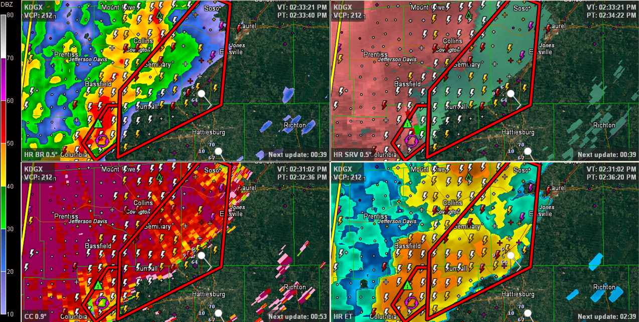
The storm is moving in the general direction of Laurel. It could get into West Alabama’s Choctaw or Sumter Counties before 5 p.m. Hopefully it will weaken before getting into Alabama.
ALABAMA UPDATE
Quite a battle of airmasses across Alabama and the Southeast at this hour. Temperatures look like this:
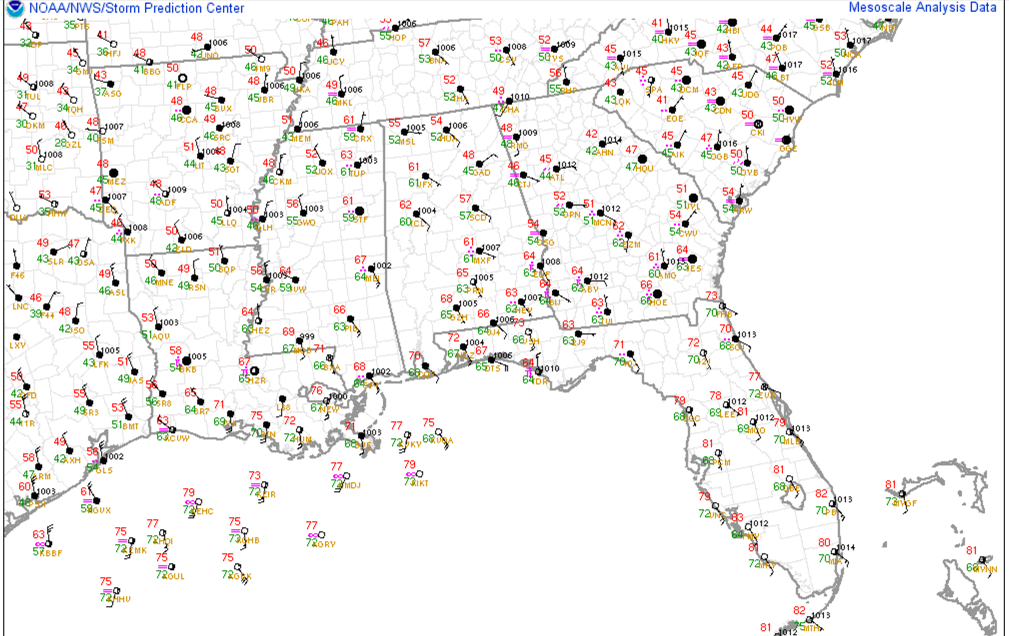
How about 42F at Athens GA and 70F at Mobile?
Or what about 48F at Gadsden and 67F at Meridian MS.
There is a warm front in there that is battling to come north and northeast against the cold air damming wedge entrenched over Georgia. It probably won’t get much further to the northeast this afternoon from its current location from somewhere over southern Pickens County southeastward to Central Montgomery County and on into Southeast Alabama.
North of the front, dewpoints are in the 40s and 50s, while south of it they quickly pop up into the 60-65F range. We will have to have those 60+F dewpoints for significant severe weather.
Rain and storms will continue in three main areas this afternoon. Ahead of the frontal zone over Central Alabama as moist southwesterly winds are lifted up and over the boundary. This overrunning is very efficient and is resulting in some heavy rainfall. Only .37 inches at the BHM Airport since midnight, but that will be changing.
Much of Lamar, northwestern Fayette, southeastern Marion and northwestern Pickens Counties have picked up well over 1 inch of rain with a widespread area of 2-3 inch amounts over Lamar. Flooding is likely in these areas.
To the west, showers and storms are lined up over West Alabama, beginning to feel the influence of the approaching cold front, which lies from east of Memphis to Vicksburg. Heavy rain and lightning were occurring from near Hamilton to west of Fayette to near Carrrollton.
These showers and storms will edge slowly east ahead of the cold front.
South of the front over southeastern Louisiana, southern Mississippi and southwestern Alabama, there is some clearing going on, and this will allow for additional destabilization of the atmosphere. Surface based CAPE values are over 500 j/kg over a wide area including southwestern Alabama, southern Mississippi and southeastern Louisiana. Values are as high as 2500 j/kg near Lafayette LA southwest of New Orleans.
The strongest showers and storms are over southern Mississippi south of Jackson, where there are severe thunderstorm and tornado warnings in effect. These storms will continue to lift northeast. But instability values over Alabama and Mississippi will slowly wane this afternoon. But wind shear values will remain high and storms will be organized and able to bring strong winds down to the ground. Damaging wind will be the main threat for us and those reports will be isolated generally.
Helicity values are highest over North and North Central Alabama, away from the best instability, which is good news as it limits the tornadic potential. There is sufficient low level shear though for a couple of tornadoes closer to the coast over Southeast Louisiana, southern Mississippi and southwestern Alabama. There is a tornado watch in effect there now.
The damaging wind threat is more widespread there as well. A large and extremely dangerous tornado is on the ground near Columbia MS.
Category: Alabama's Weather, Severe Weather
About the Author (Author Profile)
Bill Murray is the President of The Weather Factory. He is the site's official weather historian and a weekend forecaster. He also anchors the site's severe weather coverage. Bill Murray is the proud holder of National Weather Association Digital Seal #0001 @wxhistorianSubscribe
If you enjoyed this article, subscribe to receive more just like it.


