

Flash Flood Watch Expanded
The National Weather Service has expanded the Flash Flood Watch to include more of Central Alabama, mainly south of US-278 and north of US-80.

It goes through Monday at 6 a.m.
Counties added to the watch include:
Calhoun, Chambers, Cherokee, Clay, Cleburne, Etowah, Lee, Lowndes, Macon, Montgomery, Randolph and Tallapoosa.
This is in addition to the counties that were already in the watch:
Autauga, Bibb, Blount, Chilton, Coosa, Dallas, Elmore, Fayette, Greene, Hale, Jefferson, Lamar, Marengo, Marion, Perry, Pickens, Shelby, St. Clair, Sumter, Talladega, Tuscaloosa, Walker and Winston.
Some major cities included in the watch are: Hamilton, Jasper, Gadsden, Anniston, Birmingham, Tuscaloosa, Demopolis, Selma, Montgomery and Auburn.
Storm total rainfalls are expected to range between 2 and 4 inches across this entire area by Monday morning, with the heaviest amounts from Shelby County through Tuscaloosa, Hale and into Sumter and Choctaw Counties. Recent heavy rainfall amounts have resulted in saturated ground and high rivers and streams. The additional heavy rain could cause flooding.
A large rain area is moving northeast across Central Alabama at this time. It will mainly impact areas south of I-20.
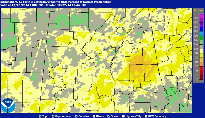
DENTING DEFICITS: Many Central Alabama locations are still well below normal in the rainfall department for 2014. It seems that nature is trying to reverse the situation with another soaking event. Birmingham is currently 6.10 inches below normal for the year and Tuscaloosa is at 5.15 inches short of average. Anniston is a little better, at 2.37 inches short, but all in all it has been a dry year.
Fortunately, the current event will bring some relief to the situation as a widespread soaking rainfall event is underway. Hopefully, we won’t deal with any flooding issues however.
A look at the water.weather.gov precipitation map for the year clearly tells the story. Only part sof Lamar, Marion and Winston Counties have been above average for the year, with scattered pockets of wetter than normal conditions across parts of Pickens, Tuscaloosa and Shelby Counties.
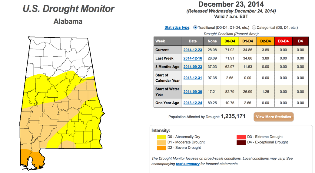
This of course translates into hyrdrological drought across parts of Alabama. Here is the U.S. Drought Monitor report for this week.
Category: Alabama's Weather, Severe Weather
About the Author (Author Profile)
Bill Murray is the President of The Weather Factory. He is the site's official weather historian and a weekend forecaster. He also anchors the site's severe weather coverage. Bill Murray is the proud holder of National Weather Association Digital Seal #0001 @wxhistorianSubscribe
If you enjoyed this article, subscribe to receive more just like it.


