

Arctic Blast For Alabama Wednesday
An all new edition of the ABC 33/40 Weather Xtreme video is available in the player on the right sidebar of the blog. You can subscribe to the Weather Xtreme video on iTunes by clicking here.
COLD TODAY; MUCH COLDER WEDNESDAY: Despite a sunny sky, temperatures are only in the 30s over the northern third of the state this afternoon, with low to mid 40s along the I-20/59 corridor. We will enjoy a one day warm-up tomorrow, with a sunny sky and a high in the mid 50s, which about where we should be in early January (the average high for Birmingham on January 6 is 53 degrees).
BITTERLY COLD AIR ARRIVES WEDNESDAY: A 1053 millibar high, representing very cold, Arctic air, will move south into the northern U.S., and north winds will increase across Alabama ushering in the big chill. We will see a high only in the mid to upper 30s, and a north wind of 15-30 mph will keep the wind chill index below freezing much of the day. There could be a few snow flurries near the Tennessee border, but not a flake is expected down our way.
The wind chill index Wednesday night will be close to zero, and by Thursday morning air temperatures will drop into the 10-15 degree range across North/Central Alabama. Many places north of Birmingham will see a single digit low.
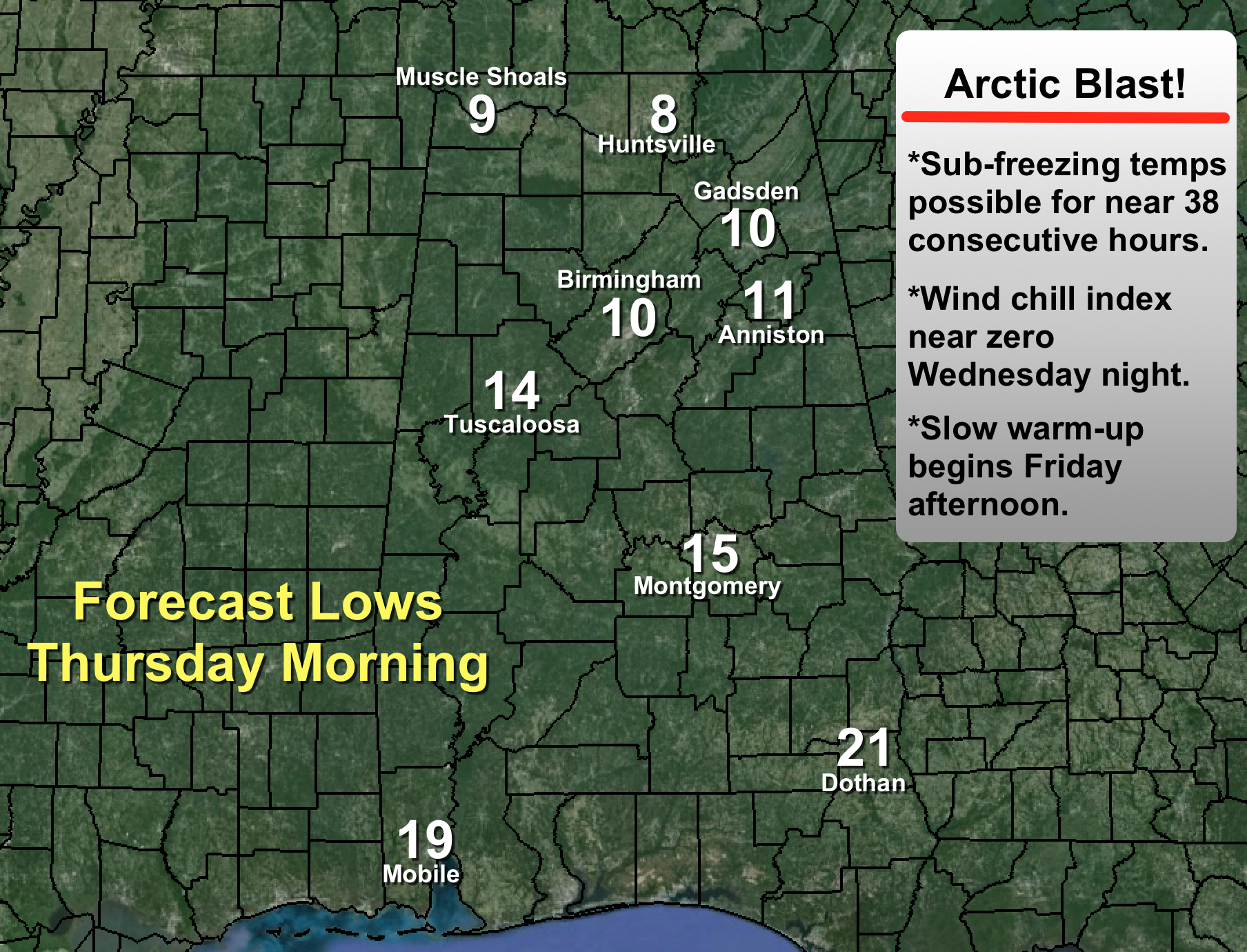
Many communities will see around 38 consecutive hours of sub-freezing temperatures from Wednesday night through Friday morning.
Keep in mind Friday morning will be pretty cold as well, with lows well down in the teens. Then, a slow warming trend begins Friday afternoon as we rise into the low 40s.
OUR WEEKEND: Saturday will be dry with a partly sunny sky and a high in the upper 40s. Then, a few scattered showers are possible Sunday with short wave energy approaching from the southwest, but for now it looks like rain amounts will be light and rather spotty. We are expecting a high in the low 50s Sunday afternoon.
LONG RANGE: The new higher resolution GFS model is suggesting the Arctic Oscillation (AO) and North Atlantic Oscillation (NAO) will trend negative at mid-month, which could open the door for longer periods of cold weather… see the Weather Xtreme video for maps, graphics, and more details.
WEATHER BRAINS: Don’t forget you can listen to our weekly 90 minute netcast anytime on the web, or on iTunes. This is the show all about weather featuring many familiar voices, including our meteorologists here at ABC 33/40. We will produce this week’s show tonight at 8:30 CT… you can watch it on “James Spann 24/7” on cable systems around the state, or on the web here.
CONNECT: You can find me on all of the major social networks…
Facebook
Twitter
Google Plus
Instagram
Look for the next Weather Xtreme video here by 7:00 a.m. tomorrow…
Category: Alabama's Weather
About the Author (Author Profile)
James Spann is one of the most recognized and trusted television meteorologists in the industry. He holds the AMS CCM designation and television seals from the AMS and NWA. He is a past winner of the Broadcast Meteorologist of the Year from both professional organizations.Subscribe
If you enjoyed this article, subscribe to receive more just like it.


