

Cold, Messy Winter Day
An all new edition of the ABC 33/40 Weather Xtreme video is available in the player on the right sidebar of the blog. You can subscribe to the Weather Xtreme video on iTunes by clicking here.
CHALLENGING FORECAST: Yet another tricky winter weather forecast as a wave in the southern branch of the jet stream approaches Alabama, with a cold airmass in place. The new upper air data that will arrive around 7:00 a.m. will let us see the current state of the atmosphere (weather balloons are launched only once every 12 hours), so keep in mind this forecast could change over the next few hours.
AT DAYBREAK: A few light snow flurries are over far Northwest Alabama, and a large mass of rain is moving into West Alabama, roughly from Tuscaloosa south. Some sleet has been reported in Tuscaloosa at the onset of the rain.
THE DAY AHEAD: Periods of rain are likely for areas along and south of I-20 (Tuscaloosa to Birmingham to Anniston). However, it seems like atmospheric profiles are cold enough for light snow over far North Alabama, mainly north of U.S. 278 (Hamilton to Cullman to Gadsden). Snow that comes today over the Tennessee Valley should be light, and with temperatures rising into the mid 30s, accumulation, if any, should be light, and impact on roads minimal. We do note the NWS in Huntsville suggests some accumulation on grassy areas up to 1/2 inch over parts of North and Northeast Alabama today…
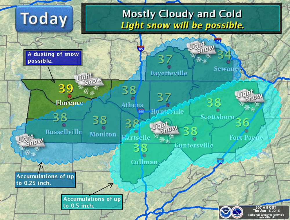
NWS offices in Huntsville, Birmingham, Jackson, and Memphis have opted not to issue any kind of winter weather advisory, and that seems like a good decision for now.
But again, the new soundings that will be coming in shortly will give us a better look at the atmosphere. You can’t determine precipitation type by looking at your backyard thermometer; the key is the temperature at about 5,000 feet off the ground. Stay tuned for updates and possible forecast changes.
Precipitation moves out of the state this evening, and the sky will clear late tonight.
BRIGHTER AND WARMER: Finally, we have two sunny days in a row with a warming trend. Expect a good supply of sunshine tomorrow and Saturday; we reach the mid 50s tomorrow, and the high Saturday will be close to 60 degrees. Then, a deep upper trough will pass overhead Sunday… this will knock the high down into the low 50s, and some scattered clouds will show up (although the weather will stay dry).
NEXT WEEK: The weather looks dry Monday through Wednesday with seasonal temperatures; highs in the 50s and lows in the 30s. The next chance of rain comes at the end of the week, around Friday January 23. Way too early to know if this system will bring any threat of snow to North Alabama, but it is not totally out of the question. Take some time to watch the Weather Xtreme video for the maps, graphics, and more details.
WEATHER BRAINS: Don’t forget you can listen to our weekly 90 minute netcast anytime on the web, or on iTunes. This is the show all about weather featuring many familiar voices, including our meteorologists here at ABC 33/40. Scroll down for the show notes for the new episode we recorded last night.
CONNECT: You can find me on all of the major social networks…
Facebook
Twitter
Google Plus
Instagram
I will be doing a weather program this morning in Gadsden for some young kids at a HeadStart program… look for the next Weather Xtreme video here by 4:00 this afternoon. Enjoy the day!
Category: Alabama's Weather
About the Author (Author Profile)
James Spann is one of the most recognized and trusted television meteorologists in the industry. He holds the AMS CCM designation and television seals from the AMS and NWA. He is a past winner of the Broadcast Meteorologist of the Year from both professional organizations.Subscribe
If you enjoyed this article, subscribe to receive more just like it.


