

Very Nice Warm-Up Today
An all new edition of the ABC 33/40 Weather Xtreme video is available in the player on the right sidebar of the blog. You can subscribe to the Weather Xtreme video on iTunes by clicking here.
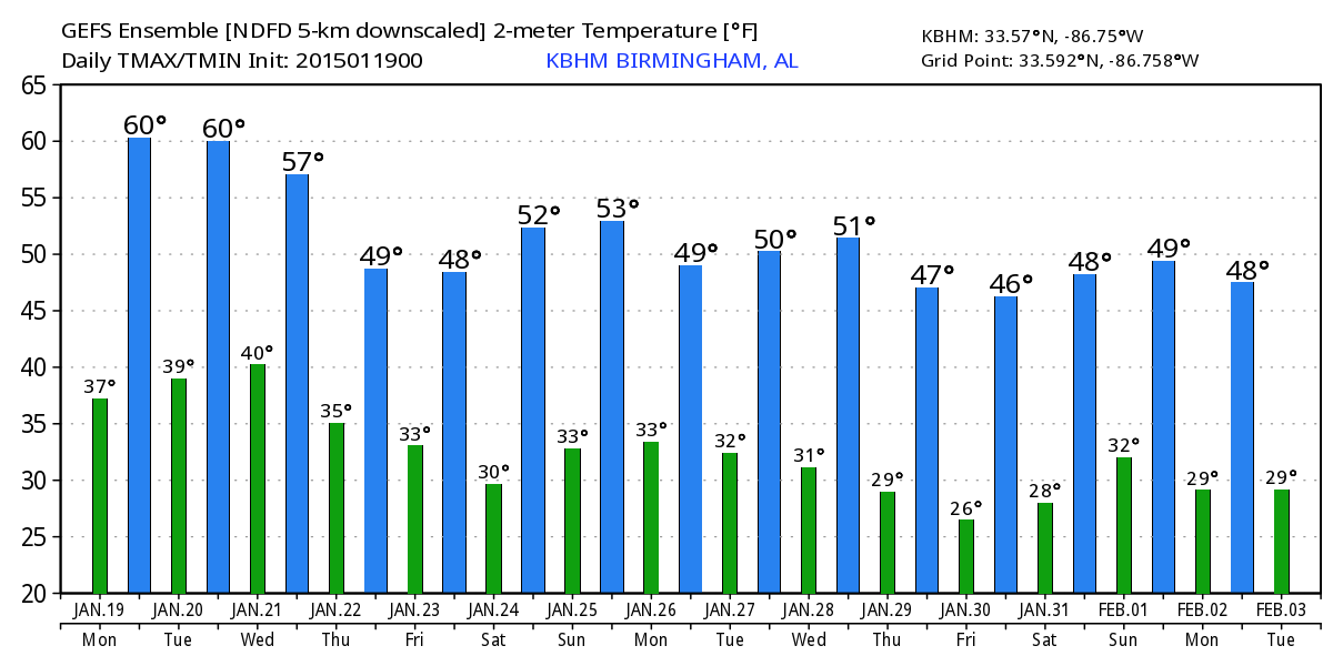
CHILLY START, MILD AFTERNOON: We begin the day with temperatures near the freezing mark, but look for a very nice warm-up today with most places enjoying a high in the mid 60s. It should be our warmest day since January 3 when Birmingham’s high was 66. The air is dry, and the sky will be mostly sunny.
Rain-free weather continues tomorrow and Wednesday with a partly sunny sky both days… temperatures trend downward slightly with a high in the low 60s tomorrow, and upper 50s Wednesday.
THURSDAY/FRIDAY: Clouds will increase Thursday ahead of a wave in the southern branch of the jet stream, and this wave will bring rain to at least the southern half of the state Thursday night and Friday morning. Global models suggest the best chance of measurable rain with this feature will come along and south of I-20 (south of a line from Tuscaloosa to Birmingham to Anniston), with only a few sprinkles to the north.
Thickness values will almost be cold enough for some light snow over the northern third of the state Thursday night, but with the main dynamic forcing well to the south and hardly any moisture in the low levels, I don’t see any reason to mention that chance in the forecast for now.
Best chance of light rain over Central and South Alabama will come from about 10:00 p.m. Thursday through 10:00 a.m. Friday. And, we should note the weather will be colder Thursday and Friday with a high between 47 and 51 degrees for North/Central Alabama.
THE ALABAMA WEEKEND: For now it looks cool and dry. A sunny sky Saturday with a high in the low to mid 50s. Clouds will slowly increase Sunday, and again the high will be in the 50-55 degree range.
An Alberta Clipper type feature will bring some risk of light rain to Alabama early next week on Monday, perhaps as early as Sunday night. These systems don’t bring much moisture to the party, and rarely produce big precipitation amounts. See the Weather Xtreme video for the maps, graphics, and long range ideas.
WEATHER BRAINS: Don’t forget you can listen to our weekly 90 minute netcast anytime on the web, or on iTunes. This is the show all about weather featuring many familiar voices, including our meteorologists here at ABC 33/40. We will produce this week’s show tonight at 8:30 CT… you can watch it on “James Spann 24/7” on cable systems around the state, or on the web here.
CONNECT: You can find me on all of the major social networks…
Facebook
Twitter
Google Plus
Instagram
Look for the next Weather Xtreme video here by 4:00 this afternoon… enjoy the day!
Category: Alabama's Weather
About the Author (Author Profile)
James Spann is one of the most recognized and trusted television meteorologists in the industry. He holds the AMS CCM designation and television seals from the AMS and NWA. He is a past winner of the Broadcast Meteorologist of the Year from both professional organizations.Subscribe
If you enjoyed this article, subscribe to receive more just like it.


