

One More Dry/Pleasant Day
An all new edition of the ABC 33/40 Weather Xtreme video is available in the player on the right sidebar of the blog. You can subscribe to the Weather Xtreme video on iTunes by clicking here.
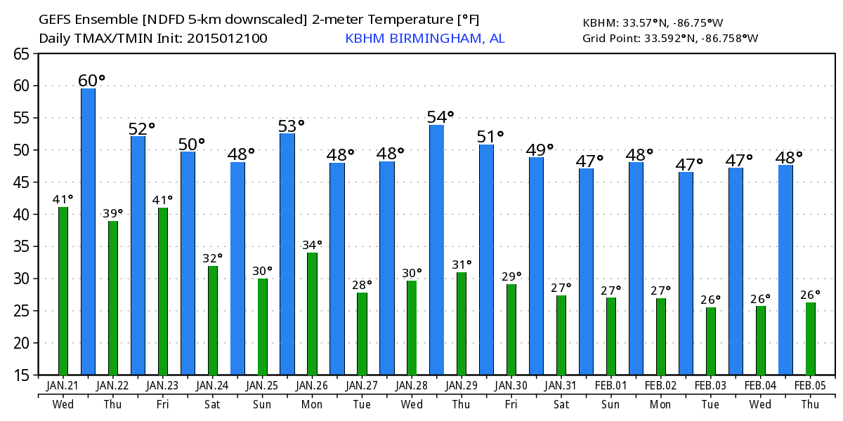
RAIN ARRIVES TOMORROW NIGHT: We will squeeze out one more pleasant mid-winter day across Alabama with a partly sunny sky and a high not too far from 60 degrees this afternoon. Clouds begin to return tonight, and tomorrow will be a cloudy and cooler day with a high in the mid 50s.
Rain will impact Southwest Alabama tomorrow afternoon, but for the north/central counties the rain begins tomorrow night, and Friday looks like a cold, rainy day. We stay in the 40s all day Friday, and rain amounts of around one inch look likely for the I-20/59 corridor (places like Birmingham, Tuscaloosa, Anniston, and Gadsden). Heavier rain will be over South Alabama, where some spots could see two inches as a surface low moves across the northern Gulf of Mexico.
The air Friday will be stable, so no thunder, and the rain won’t be heavy enough for any flooding issues. And, the air will be too warm for any ice or snow issues during the day.
FRIDAY NIGHT/EARLY SATURDAY: The surface low moves northeast, and as colder air drops southward there is some chance the rain could change to snow over Tennessee. Even some risk of a snow flake or two down into extreme North Alabama, but we expect no impact if that happens with surface temperatures above freezing and with the deeper moisture well to the east.
OUR WEEKEND: The sky becomes partly sunny Saturday with an afternoon high in the low 50s, and Sunday looks cool and dry with mixed sun and clouds and a high in the mid 50s.
MONDAY: An Alberta Clipper will impact Alabama along with a deep, cold upper trough. Moisture will be very limited, and these features rarely produce much precipitation in our state. We will mention a chance of some scattered light rain for now… the cold air aloft associated with the upper trough could bring enough dynamic cooling for a few snow flurries over the northern third of the state, but again no impact is expected with very little moisture and surface temperatures above freezing.
Tuesday and Wednesday of next week are looking cool and dry.
VOODOO LAND: Interesting to note the European model (ECMWF) is showing a big negative NAO/AO spike as February begins, but remains to be seen if that will verify. See the Weather Xtreme video for the maps, graphics, and more details.
WEATHER BRAINS: Don’t forget you can listen to our weekly 90 minute netcast anytime on the web, or on iTunes. This is the show all about weather featuring many familiar voices, including our meteorologists here at ABC 33/40.
CONNECT: You can find me on all of the major social networks…
Facebook
Twitter
Google Plus
Instagram
I will be speaking at a meeting today of the Tuscaloosa Area Alabama Power Company retiree group, The Energizers… and then this evening I will be at circus at the BJCC in Birmingham on ABC 33/40 News at 4, 5, and 6:00. Hope to produce an afternoon Weather Xtreme video, which will be posted by 4:00 p.m. Enjoy the day!
Category: Alabama's Weather
About the Author (Author Profile)
James Spann is one of the most recognized and trusted television meteorologists in the industry. He holds the AMS CCM designation and television seals from the AMS and NWA. He is a past winner of the Broadcast Meteorologist of the Year from both professional organizations.Subscribe
If you enjoyed this article, subscribe to receive more just like it.


