

Rather Quiet Weather For Alabama
An all new edition of the ABC 33/40 Weather Xtreme video is available in the player on the right sidebar of the blog. You can subscribe to the Weather Xtreme video on iTunes by clicking here.
THE BLIZZARD IS THE STORY: As expected, the sky has cleared over most of Alabama this afternoon, with the clouds hanging tough over the far eastern part of the state. Temperatures are mostly in the 40s. Up north, snow is increasing in intensity in New York City this afternoon… this shot is from Central Park at mid-afternoon (photo from @my_cen_parkNYC)
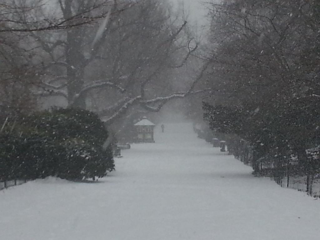
Blizzard warnings remain in effect from the New Jersey shore to the coast of Maine, including New York City, Hartford, Providence, and Boston. Snow amounts around two feet are likely with winds to 50 mph at times. Airports are closing, and travel will be nearly impossible across that region tonight and tomorrow.
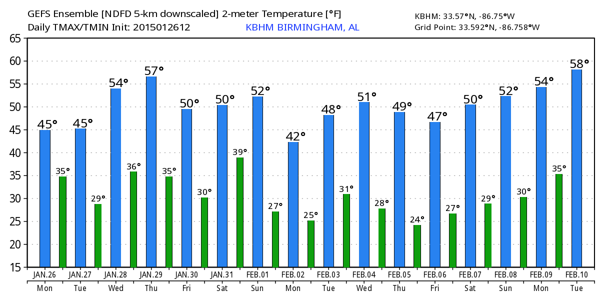
HERE AT HOME: A few cloudy periods are possible tomorrow, and I can’t totally rule out a little morning drizzle in spots over East Alabama, but the day will be dry with a high in the low 50s. Wednesday should be bright and sunny with a high in the mid 50s.
On Thursday, a clipper will pass well north of the state, but it could drag some clouds down into North Alabama. We will mention a small risk of a shower over the northeast counties of the state, but most communities stay dry with a high in the upper 50s Thursday afternoon.
FRIDAY AND THE WEEKEND: Friday and Saturday will be dry with seasonal temperatures; highs in the 50s and lows in the 30s. Clouds begin to increase Saturday afternoon, and Sunday still looks wet with periods of rain as a significant upper trough passes through. Rain amounts of 1/2 to 1 inch look likely Sunday; no risk of severe weather, and conditions are way too warm for any winter weather mischief.
Colder and drier air returns early next week; we won’t get out of the 40s Monday with a chilly north wind.
LONG TERM: While temperatures will be below average early next week, no sign of bitterly cold air for now through mid-February.
See the Weather Xtreme video for maps, graphics, and more details.
WEATHER BRAINS: Don’t forget you can listen to our weekly 90 minute netcast anytime on the web, or on iTunes. This is the show all about weather featuring many familiar voices, including our meteorologists here at ABC 33/40. We will produce this week’s show tonight… it will begin at an early time so we can provide coverage of the Northeast U.S. blizzard. Show time is 8:00 CT… you can watch it on “James Spann 24/7” on cable systems around the state, or on the web here.
CONNECT: You can find me on all of the major social networks…
Facebook
Twitter
Google Plus
Instagram
I had a great time today visiting with the kids in the Sumter County HeadStart program; we were together at the Livingston Community Center… be watching for them on the Pepsi KIDCAM today at 5:00 on ABC 33/40 News! The next Weather Xtreme video will be posted here by 7:00 a.m. tomorrow….
Category: Alabama's Weather
About the Author (Author Profile)
James Spann is one of the most recognized and trusted television meteorologists in the industry. He holds the AMS CCM designation and television seals from the AMS and NWA. He is a past winner of the Broadcast Meteorologist of the Year from both professional organizations.Subscribe
If you enjoyed this article, subscribe to receive more just like it.


