

Cooler Today; Rain By Sunday
An all new edition of the ABC 33/40 Weather Xtreme video is available in the player on the right sidebar of the blog. You can subscribe to the Weather Xtreme video on iTunes by clicking here.
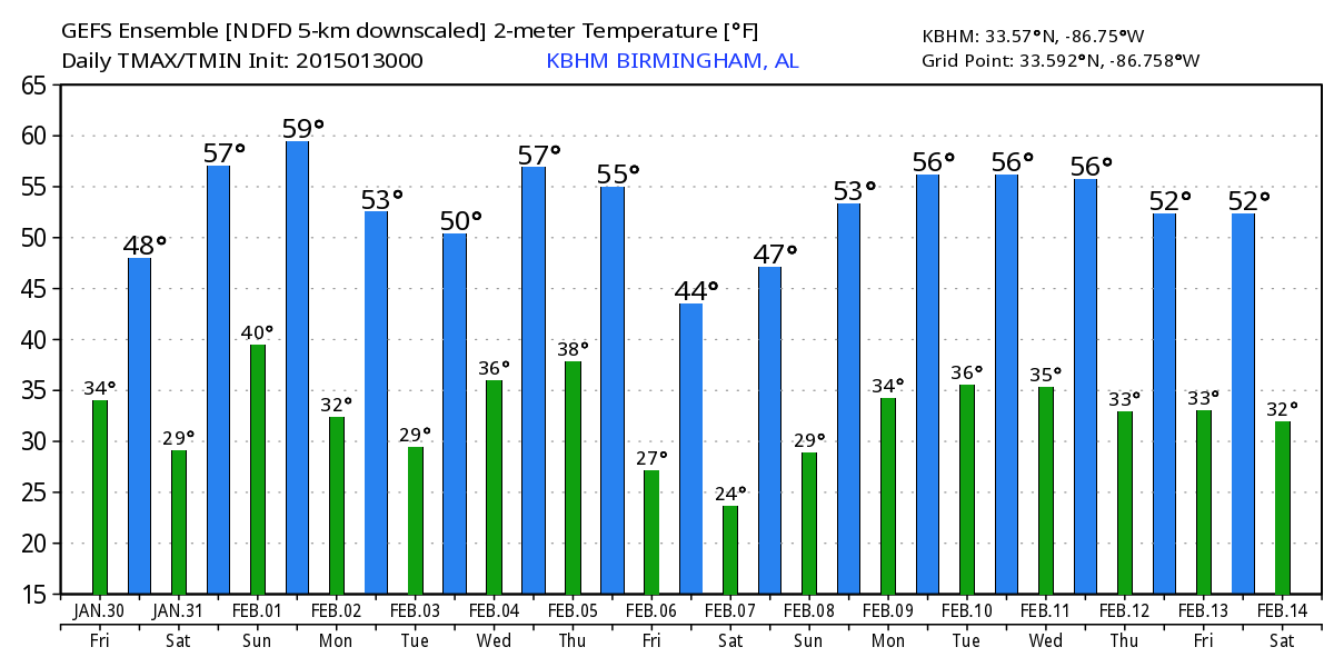
SUNNY, BUT COOL: A cold front passed through Alabama last night; many noticed the strong north winds that developed right behind the boundary. Thanks to that front today will be noticeably cooler with a high around 50 degrees; that is about 15 degrees cooler than the highs we enjoyed yesterday. We note Tuscaloosa soared to 72 degrees yesterday, not bad for late January in Alabama. The air over Alabama is very dry, and we expect sunshine in full supply today.
THE ALABAMA WEEKEND: Dry weather continues Saturday with a partly sunny sky; we start the day in the 25-29 degree range, but rise into the mid 50s by afternoon. Clouds thicken late in the day and Saturday night, ahead of a storm system to the west. Then, rain returns Sunday with a surface low passing just northwest of Alabama. The rain should begin by mid-morning, and continue at times through Sunday night. A few thunderstorms could be in the mix, but with a stable airmass we don’t expect any severe weather problems. Rain amounts of 1/2 to 3/4 inch look likely, with isolated amounts to one inch.
NEXT WEEK: Sharply colder air moves into Alabama Monday following the rain, and we will continue to mention a chance of snow flurries Monday morning in the cold air. No impact, however, with temperatures above freezing at the surface, and the deeper moisture off to the east. Monday’s high will be in the low to mid 40s with a strong north wind to make it feel colder.
A pretty significant freeze is likely at daybreak Tuesday, with a low in the 20-25 degree range. Tuesday will be dry with a high close to 50 degrees.
Then, the next wave in the southern branch of the jet stream will bring the next chance of rain Wednesday; we don’t have model consistency in this feature; some global model runs keep the best chance of rain over South Alabama, others show a good wet-down for the entire state. And, the European model wants to hold off the best chance of rain until Wednesday night and maybe Thursday. For now we will just mention a chance of rain for the entire state Wednesday and we can make adjustments as needed.
Then, another shot of colder air moves in late in the week. See the Weather Xtreme video for maps, graphics, and more details.
WEATHER BRAINS: Don’t forget you can listen to our weekly 90 minute netcast anytime on the web, or on iTunes. This is the show all about weather featuring many familiar voices, including our meteorologists here at ABC 33/40.
CONNECT: You can find me on all of the major social networks…
Facebook
Twitter
Google Plus
Instagram
I have a weather program today at Bluff Park Elementary in Hoover… be looking for the next Weather Xtreme video here by 4:00 this afternoon. Enjoy the day!
Category: Alabama's Weather
About the Author (Author Profile)
James Spann is one of the most recognized and trusted television meteorologists in the industry. He holds the AMS CCM designation and television seals from the AMS and NWA. He is a past winner of the Broadcast Meteorologist of the Year from both professional organizations.Subscribe
If you enjoyed this article, subscribe to receive more just like it.


