

Severe Thunderstorm Warning Sumter and Greene Counties
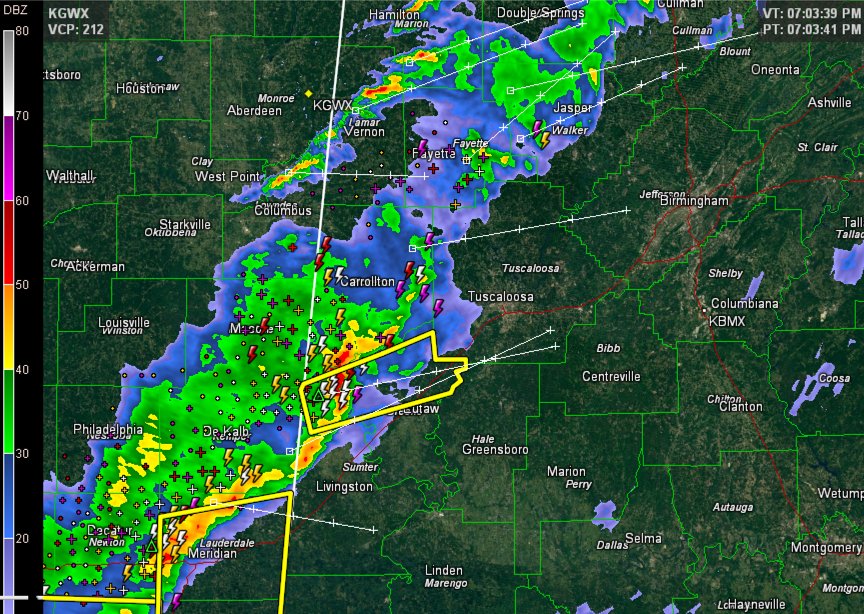
Strong radar indications of damaging winds in the bow echo crossing the Alabama border into Sumter County have prompted a severe thunderstorm warning for Sumter and for downstream Greene County tonight.
The storm is just east of Geiger and will move east northeast toward Gainesville, Union, Clinton and Knoxville. There have been several reports of damaging winds across Mississippi from this storm, mainly downed trees.
The storms will move into southern Tuscaloosa County, mainly remaining south of I-59, but should gradually weaken as it outruns its instability.
THE NATIONAL WEATHER SERVICE IN BIRMINGHAM HAS ISSUED A
* SEVERE THUNDERSTORM WARNING FOR…
NORTHERN GREENE COUNTY IN WEST CENTRAL ALABAMA…
NORTH CENTRAL SUMTER COUNTY IN WEST CENTRAL ALABAMA…
* UNTIL 730 PM CST
* AT 658 PM CST…THE NATIONAL WEATHER SERVICE INDICATED A SEVERE
THUNDERSTORM CAPABLE OF PRODUCING DAMAGING WINDS IN EXCESS OF 60
MPH. THIS STORM WAS LOCATED 5 MILES NORTHWEST OF GAINESVILLE…OR
18 MILES SOUTH OF ALICEVILLE…AND MOVING EAST AT 60 MPH.
* LOCATIONS IMPACTED INCLUDE…
NEW WEST GREENE…WEST GREENE…UNION…MANTUA…KNOXVILLE…NEW
MOUNT HEBRON…PLEASANT RIDGE AND CLINTON.
THIS INCLUDES…
INTERSTATE 20 EXIT NUMBERS 45 THROUGH 52…
Category: Alabama's Weather, Severe Weather
About the Author (Author Profile)
Subscribe
If you enjoyed this article, subscribe to receive more just like it.


