

Warmer Tomorrow; Winter Weather Issues Monday
An all new edition of the ABC 33/40 Weather Xtreme video is available in the player on the right sidebar of the blog. You can subscribe to the Weather Xtreme video on iTunes by clicking here.
COLD FRIDAY THE 13TH: Temperatures are only in the 39-44 degree range across North/Central Alabama this afternoon despite a mostly sunny sky. Tonight will be cold again with most communities dropping down into the mid 20s.
ONE DAY WARM-UP: Tomorrow will be the nicest day of the weekend; we warm to near 60 degrees tomorrow afternoon with a sunny sky. The warmth won’t last long; another surge of cold air blows in here tomorrow night, and by early Sunday we will be in the 15-20 degree range (the GFS is printing a low of 17 for Birmingham early Sunday). Sunday’s high will be between 37 and 40 degrees despite a sunny sky.
WINTER STORM THREAT LATE SUNDAY NIGHT INTO MONDAY: Not much change in our overall thinking on the beginning of this event…
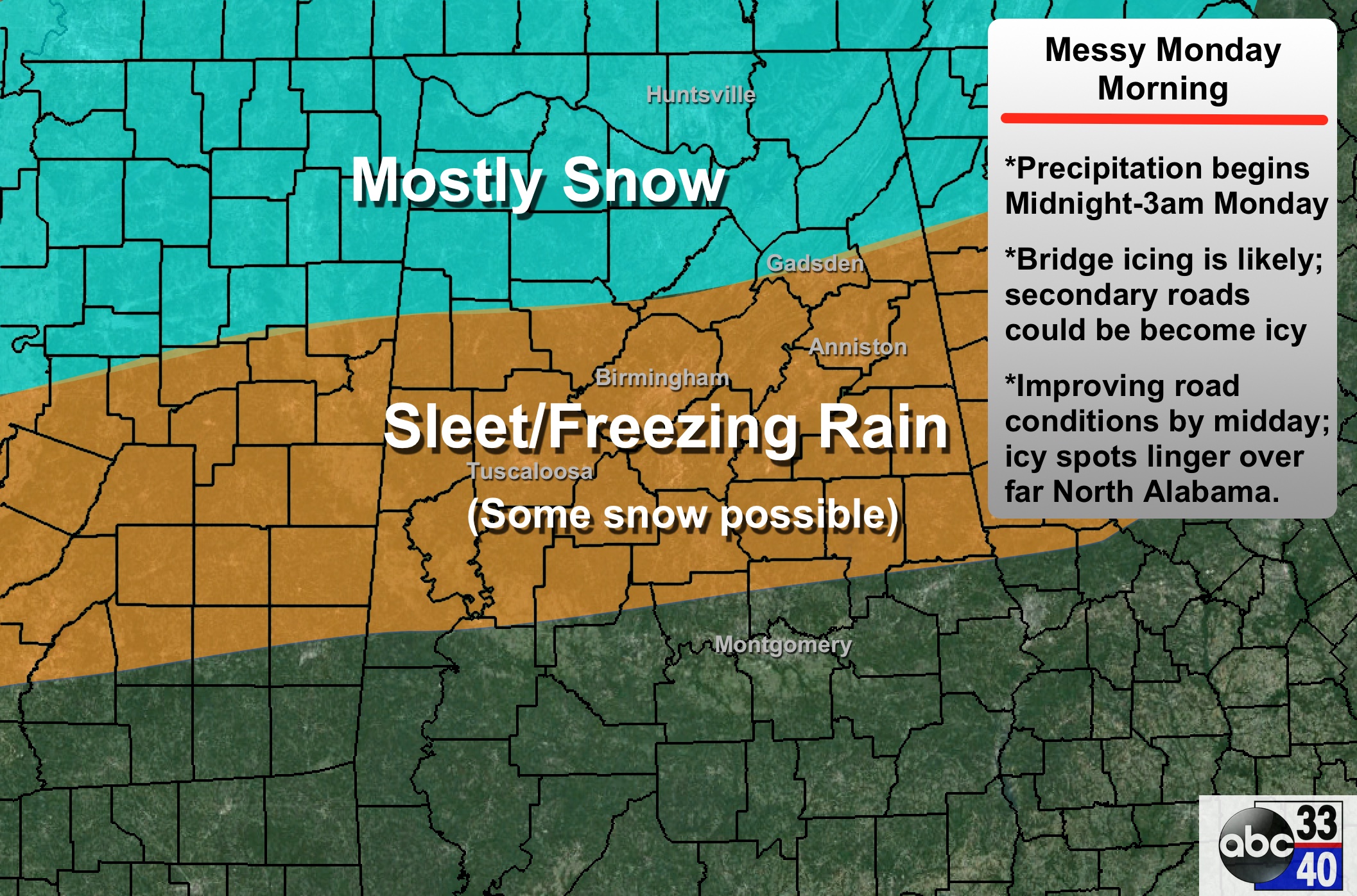
TIMING: Looks like the precipitation now could arrive as early as midnight Sunday night. The primary threat of icy travel problems will come from about 2:00 a.m. until 12:00 noon. Isolated icy patches could linger into Monday afternoon across the Tennessee Valley of extreme North Alabama, but temperatures should generlly rise above freezing in most places by late morning.
PRECIPITATION TYPE: It looks like all snow along and north of U.S. 278, or north of a line from Hamilton to Cullman to Gadsden. To the south, Birmingham, Tuscaloosa, and Anniston will have a “wintry mix” of snow, sleet, and freezing rain. Some sleet/freezing rain is possible as far south as Livingston, Clanton, and Roanoke.
ACCUMULATION: The Tennessee Valley could see 1-2 inches of snow Monday morning; amounts to 1 inch are possible along the I-20/59 corridor, but keep in mind much of the precipitation there could be in the form of sleet and freezing rain. Ice accumulation to 1/10 of an inch is possible through Central Alabama.
IMPACT: With temperatures in the 20s, bridges and overpasses will likely become icy across North/Central Alabama as the precipitation falls. Ice is possible on secondary road surfaces (not just bridges) as well. Travel will be difficult. We do not expect enough freezing rain to create power outages at this time.
UNCERTAINTY: As always, this could change, but confidence is growing with good model consistency.
MONDAY NIGHT/TUESDAY: Forecast confidence is much lower for this period. As I expected, the 12Z GFS has pulled the precipitation shield to the north, hinting at some rain Monday night into early Tuesday, with potential for a change to snow during the day Tuesday on the northern periphery of the precipitation shield as a surface low passes to the south.
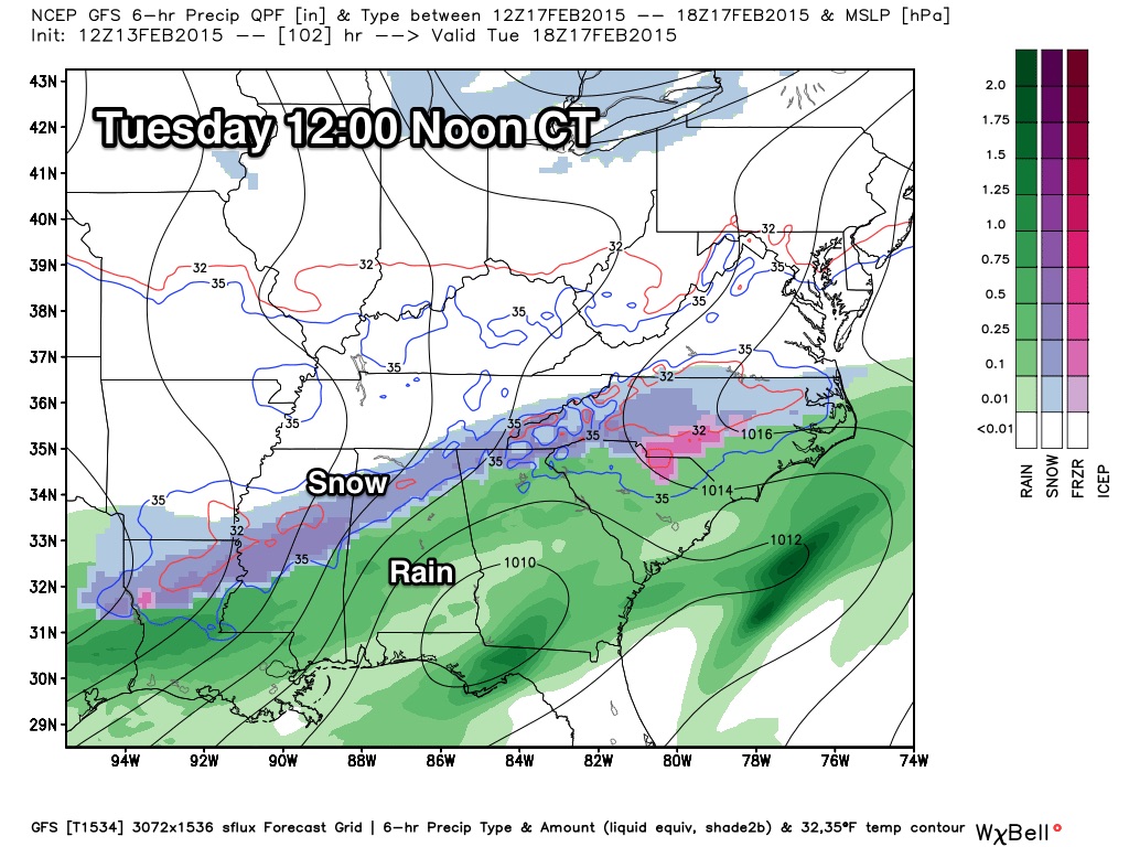
No point in getting specific about Tuesday with such low forecast confidence, but accumulating snow will be possible somewhere across North or Central Alabama. The precipitation will wind down Tuesday night… could we have travel problems Tuesday night and Wednesday? Very possible, but too early to call for now.
REST OF THE WEEK: Wednesday will be cold and dry; a clipper system could bring some light snow to parts of North Alabama Thursday. See the Weather Xtreme video for maps, graphics, and more details.
FIRST ALERT STORM TEAM TOUR: Our annual severe weather awareness tour across Alabama rolls along; we will be in Cordova next Thursday evening. Just drop by anytime from 4:00 until 6:30… you can watch me do weather live on ABC 33/40, get some free stuff to take home, and have a chance to win several NOAA Weather Radios we will be giving away. If you need your weather radio programmed or checked, bring it by and we will be glad to help.
WEATHER BRAINS: Don’t forget you can listen to our weekly 90 minute netcast anytime on the web, or on iTunes. This is the show all about weather featuring many familiar voices, including our meteorologists here at ABC 33/40.
CONNECT: You can find me on all of the major social networks…
Facebook
Twitter
Google Plus
Instagram
Look for the kids from Webster Christian School, and Hall Kent Elementary School in Homewood on the Pepsi KIDCAM this evening at 5:00 and 6:00 on ABC 33/40 News… we will have frequent updates on the blog throughout the weekend, so stay tuned!
Category: Alabama's Weather
About the Author (Author Profile)
James Spann is one of the most recognized and trusted television meteorologists in the industry. He holds the AMS CCM designation and television seals from the AMS and NWA. He is a past winner of the Broadcast Meteorologist of the Year from both professional organizations.Subscribe
If you enjoyed this article, subscribe to receive more just like it.


