

Presidents’ Day Storm Travel Nightmares – Southern Edition
Many folks will be traveling on the Presidents’ day holiday Monday. Let’s go area by area in the affected region across the South to put the travel impacts in perspective.
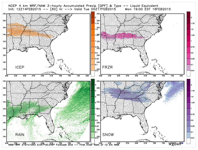
Here is the 4 km NAM depiction of the four types of precipitation that can be expected between now and 6 p.m. Monday:
Checking in on warnings and impacts going from west to east:
NORTH TEXAS
…Light icing across their northeastern counties along the Red River from Bowie to Sherman to Paris. Just a cold rain for the Metroplex.
ARKANSAS/LOUISIANA/NORTHEAST TEXAS
…Winter Storm Watch for all of Arkansas, except for the northwestern corner around Fayetteville. Snow is expected across the north in places like Mountain Home and Blytheville, where 2-4 inches of snow will fall. Up to 1/4 of an inch of freezing rain and 1 to 3 inches of snow and sleet is expected to fall across the middle of the state in places like Mena and Little Rock. The southeastern part of Arkansas around Pine Bluff is expecting one half inch of freezing rain and and inch of snow and sleet. This will cause significant icing problems including impassable roads, numerous tree limbs falling and widespread power outages. Further south, one tenth of an inch of feezing rain is expected along the US-82 corridor from Texarkana to El Dorado to Timing: beginning Sunday night and continuing through Tuesday.
WESTERN TENNESSEE/NORTHERN MISSISSIPPI
…Winter Storm Watch from Sunday evening through much of Tuesday. Up to one tenth of an inch of ice and 1 to 3 inches of snow and sleet will fall across western Tennessee, including the Memphis and Jackson areas and across the northern counties of Mississippi, including places like Oxford and Tupelo. This will cause widespread travel problems and some utility outages.
CENTRAL MISSISSIPPI
…Winter Storm Watch for the NWS Jackson’s northern tier of counties from Greenville and Greenwood over to Columbus, along the US-82 corridor. One quarter of an inch of ice will cause travel problems and some utility outages. This activity will extend eastward to near Columbus, Areas just south of the US-82 corridor but north of Vicksburg, Jackson and Meridian will experience light icing with some travel problems. South of that, it will be a cold rain.
MIDDLE TENNESSEE
…Winter Storm Watch for Sunday night through Monday night for 2 to 4 inches of snow accumulation across much of much of Middle Tennessee, including Nashville and Lawrenceburg. More snow is likely Tuesday and Tuesday night.
NORTH ALABAMA
…A Winter Storm Watch is in effect for the Tennessee Valley of North Alabama including Florence, Huntsville/Decatur and Scottboro and Fort Payne starting Sunday night and going through Monday night for 2-4 inches of snow, although there are some recent indications that freezing rain and sleet may be more of a problem as well.
CENTRAL ALABAMA
…Winter Storm Watch for areas north of a line generally from Moundville to Calera to Roanoke, including Tuscaloosa, Fayette, Jasper, Birmingham, Pelham, Talladega, Anniston, Jacksonville and ROanoke. Snow beginning in northwestern sections around or after midnight Sunday night, transitioning to a freezing rain and sleet mix through the pre-dawn hours Monday as far south as I-85 between Montgomery and Auburn.
NORTH GEORGIA
…The NWS Atlanta has not issued a Winter Storm Watch yet as their main impacts will not come until after Sunday night. Accumulated snow and sleep with affect the northern third of the state, including Rome, Atlanta and Gainesville starting Monday and lasting through Tuesday. The area from Rome to Gainesville may see mainly sleet with one half inch causing travel problems. For the Atlanta area, it will be dreaded freezing rain starting Monday morning with the potential for over one quarter of an inch of ice. This will cause significant travel issues and some power outages.
ALABAMA POWER IS READY, ARE YOU? Our friends at Alabama Power are monitoring the forecast closely, ready to deploy people and assets to quickly address any outages that might occur. Read a special message from Ike Piggot about their commitment to their customers.
Category: Alabama's Weather, Headlines, Winter Weather
About the Author (Author Profile)
Bill Murray is the President of The Weather Factory. He is the site's official weather historian and a weekend forecaster. He also anchors the site's severe weather coverage. Bill Murray is the proud holder of National Weather Association Digital Seal #0001 @wxhistorianSubscribe
If you enjoyed this article, subscribe to receive more just like it.


