

Three Items On The Plate
An all new edition of the ABC 33/40 Weather Xtreme video is available in the player on the right sidebar of the blog. You can subscribe to the Weather Xtreme video on iTunes by clicking here.
Let’s take them one at a time…
1. SNOW SHOWERS TOMORROW MORNING: A clipper type system will bring the risk of snow showers/flurries to North Alabama tomorrow morning. The NWS in Huntsville has issued a winter weather advisory for their area up in the Tennessee Valley for potential for 1/2″ of snow, with isolated higher amounts.
These type systems usually don’t cause widespread issues, but heavier snow showers can make the ground white, and with temperatures below freezing, it could impact travel in a few places. To the south, a few snow flurries or showers are possible as far south as I-20, but it is doubtful it impacts travel in places like Birmingham. We watch radar trends closely, but for now the best chance of icy travel tomorrow morning will be north of U.S. 278, or north of a line from Hamilton to Cullman to Gadsden.
The main window for snow showers and flurries will come from about 4:00 until 10:00 a.m. Otherwise, tomorrow will be mostly cloudy and cold with a high in the low 40s.
2. ARCTIC COLD THURSDAY: Some of the coldest air this winter will flood Alabama tomorrow night. By daybreak Thursday, we should be in the 10-15 degree range, with potential for a few single digits lows up over far North Alabama. Most communities will stay below freezing all day with a high only in the low 30s… but on the positive side the sun should be out in full force. Clouds return Thursday night.
3. WINTER PRECIPITATION FRIDAY: The models remain bullish on the chance of a “wintry mix” over North Alabama Friday as cold, Arctic remains in place.
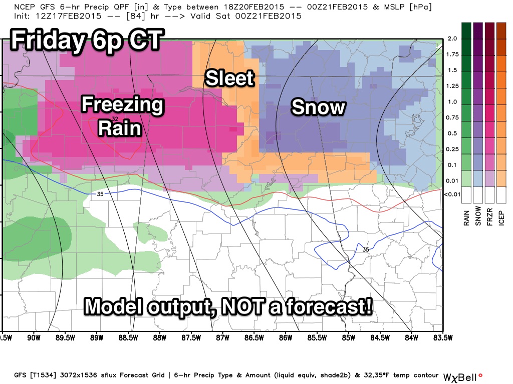
Looks like there will be a good chance of freezing rain, sleet, or snow along and north of a line from Millport to Birmingham to Anniston. I will have my first specific forecast for this event tomorrow morning. Like the event Monday, warm air advection will begin Friday afternoon, and it will be a big challenge in drawing the line between a cold rain and the wintry precipitation.
This could be a high impact event for parts of North Alabama, especially Northeast Alabama, where the cold air damming (CAD) effect could keep cold air in place longer. Some freezing rain will be possible there through Friday night.
OUR WEEKEND: Warmer air takes over, but the weather stays wet. We will forecast periods of rain both Saturday and Sunday with highs in the 55-60 degree range.
Colder and drier air will return to Alabama early next week. See the Weather Xtreme video for maps, graphics, and more details.
WEATHER BRAINS: Don’t forget you can listen to our weekly 90 minute netcast anytime on the web, or on iTunes. This is the show all about weather featuring many familiar voices, including our meteorologists here at ABC 33/40.
CONNECT: You can find me on all of the major social networks…
Facebook
Twitter
Google Plus
Instagram
Look for the next Weather Xtreme video here by 7:00 a.m. tomorrow…
Category: Alabama's Weather
About the Author (Author Profile)
James Spann is one of the most recognized and trusted television meteorologists in the industry. He holds the AMS CCM designation and television seals from the AMS and NWA. He is a past winner of the Broadcast Meteorologist of the Year from both professional organizations.Subscribe
If you enjoyed this article, subscribe to receive more just like it.


