

Arctic Cold; A Few Flurries Today
An all new edition of the ABC 33/40 Weather Xtreme video is available in the player on the right sidebar of the blog. You can subscribe to the Weather Xtreme video on iTunes by clicking here.
Like we stated here yesterday, there are three big issues we are dealing with over the next few days. The first two are an easy forecast, but the third is a challenge.
1. SNOW FLURRIES TODAY: Ahead of an Arctic cold front, we will continue to mention the chance of snow flurries/showers this morning. Significant accumulation/travel impact is not expected for places like Birmingham, Tuscaloosa, Anniston, and Gadsden, but the NWS Huntsville maintains a winter weather advisory for their counties in far North Alabama, where up to 1/2 inch is possible in spots. A dusting of snow is already down across much of the Tennessee Valley at daybreak.
2. ARCTIC COLD: We will struggle to reach 40 degrees again today, but the real cold air arrives tonight. Early tomorrow, we expect a low between 10 and 15 degrees, with a wind chill index near zero. To the north, a few spots across the Tennessee Valley could see single digit lows. Tomorrow will be sunny but very cold, with a high between 28 and 32 degrees. Up near the Tennessee border, the high will be only in the mid 20s.
Records could very well be established… Here’s the current record minimum temperatures and record low maximum temperatures for Feb 19th:
Record Minimum Temps:
Birmingham…….12 (1958)
Montgomery……18 (1958)
Tuscaloosa……..14 (1958)
Anniston…………..9 (1905)
Record Low Maximum Temps:
Birmingham…….36 (1936)
Montgomery……43 (1936)
Tuscaloosa……..39 (1959)
Anniston………….37 (1958)
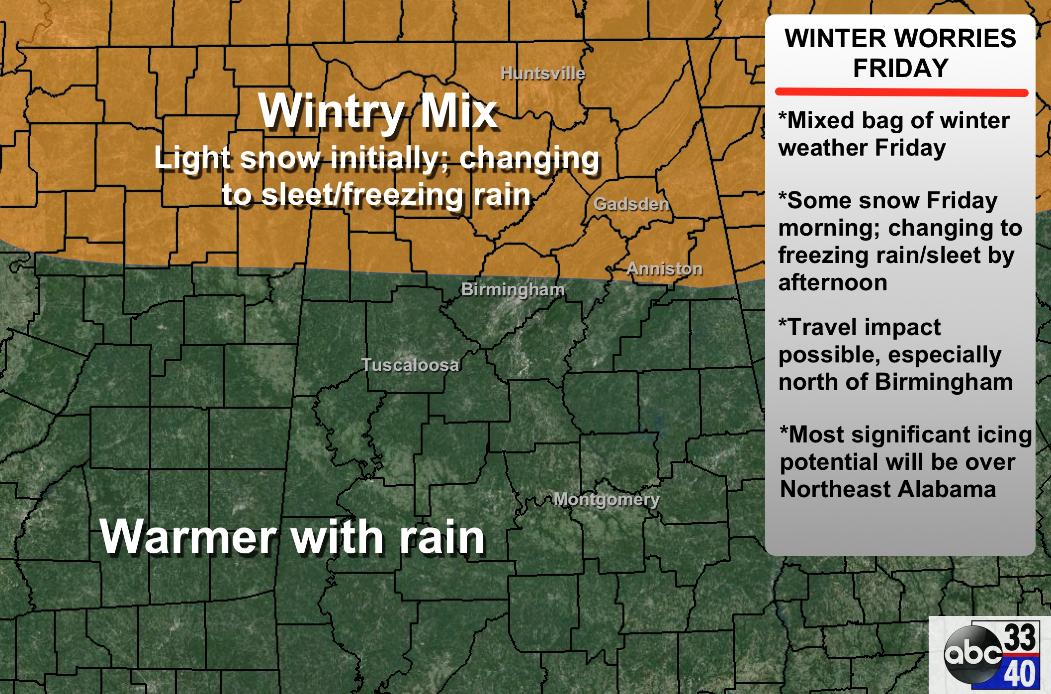
3. WINTRY MIX FRIDAY: It will be a battle between the warm air advection process (WAA), and very cold air entrenched over North Alabama. It will be somewhat similar to Monday’s event, but the one big difference is that temperatures are starting off noticeably colder.
TIMING: Light snow should begin over North Alabama (generally north of I-20) Friday morning, after 9:00 a.m. I don’t think we will have any travel impact early Friday during rush hour.
PLACEMENT: Highest chance of wintry precipitation will be north of a line from Millport to Gardendale to Oxford.
PRECIPITATION TYPE: It should begin as light snow, with a gradual change to sleet and freezing rain as warmer air aloft spreads in from the south. Then, it all changes to rain late Friday afternoon and Friday, with the exception of Northeast Alabama, where freezing rain could fall much of Friday night.
IMPACT: There could be travel impact with icy bridges/roads Friday afternoon, especially north of U.S. 278 (Hamilton to Cullman to Gadsden). But, as the warm nose moves in from the south, roads just become wet Friday night. The one big exception is Northeast Alabama, where it is harder for the cold air to be scoured out. A significant accumulation of ice seems possible for counties like Jackson, DeKalb, and Cherokee. Possibly for Marshall, Etowah, Cleburne, and parts of Calhoun. Too early to be really specific, but there could be enough ice accumulation for some power outages Friday night across this part of Alabama.
PLEASE READ the “ten things you need to know about winter weather forecasting”. All points are relevant here. This forecast can, and probably will change.
THE ALABAMA WEEKEND: Periods of rain will continue on Saturday over the northern third of the state, but it will be much warmer with a high between 57 and 60. Best chance of rain will be along and north of I-20… the southern two-thirds of Alabama will be mostly dry and very mild; some places south of Montgomery will be close to 70 degrees Saturday afternoon.
Then, Sunday, a cold front moves in, and we will probably have thunderstorms involved as the wet pattern continues. The high Sunday will be close to 60.
NEXT WEEK: Colder and drier air returns for the first half of next week, with highs mostly in the 40s, and lows mostly in the 20s. See the Weather Xtreme video for maps, graphics, and more details.
FIRST ALERT STORM TEAM TOUR: Our annual severe weather awareness tour across Alabama rolls along; we will be in Cordova tomorrow evening. Just drop by anytime from 4:00 until 6:30… you can watch me do weather live on ABC 33/40, get some free stuff to take home, and have a chance to win several NOAA Weather Radios we will be giving away. If you need your weather radio programmed or checked, bring it by and we will be glad to help.
WEATHER BRAINS: Don’t forget you can listen to our weekly 90 minute netcast anytime on the web, or on iTunes. This is the show all about weather featuring many familiar voices, including our meteorologists here at ABC 33/40.
CONNECT: You can find me on all of the major social networks…
Facebook
Twitter
Google Plus
Instagram
I have a weather program this morning at Indian Valley Elementary School in Sylacauga… look for the next Weather Xtreme video here by 4:00 this afternoon. Enjoy the day!
Category: Alabama's Weather
About the Author (Author Profile)
James Spann is one of the most recognized and trusted television meteorologists in the industry. He holds the AMS CCM designation and television seals from the AMS and NWA. He is a past winner of the Broadcast Meteorologist of the Year from both professional organizations.Subscribe
If you enjoyed this article, subscribe to receive more just like it.


