

Winter Weather Issues For North Alabama
An all new edition of the ABC 33/40 Weather Xtreme video is available in the player on the right sidebar of the blog. You can subscribe to the Weather Xtreme video on iTunes by clicking here.
FRIGID WINTER DAY: Birmingham’s official low this morning was 13 degrees… just missing the record of 12 for the date, set in 1958. Coldest observation I would find was 6 degrees at a site 3 miles south of Hamilton in Marion County (scroll down for a long list of morning lows). As expected, just about everybody across North/Central Alabama remains below freezing this afternoon despite the sunshine; Tuscaloosa is one of the few spots above freezing with 33.
WINTER WEATHER ISSUES TOMORROW FOR NORTH ALABAMA: Not much change in our overall thinking.
The National Weather Service in Huntsville has issued a winter storm warning for Madison, Jackson, and DeKalb Counties, along with a winter weather advisory for the rest of the counties up in the Tennessee Valley…
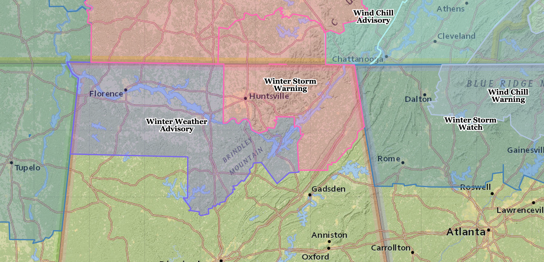
The NWS in Birmingham has opted not to issue any advisories for their county warning area at this point.
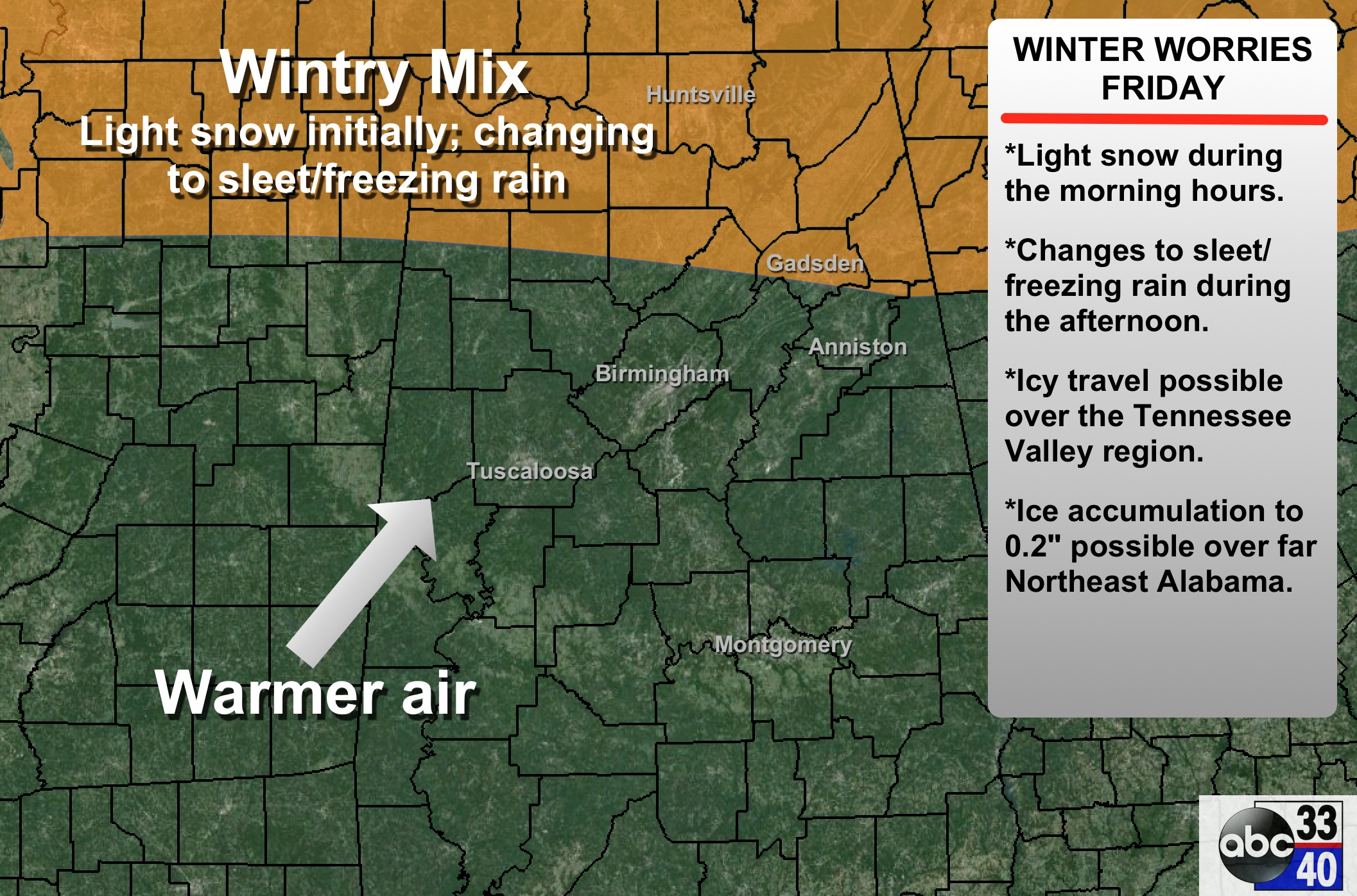
PLACEMENT: Greatest risk of wintry precipitation will be north of a line from Hamilton to Cullman to Piedmont. For now we do not expect any impact for Birmingham, Tuscaloosa, and Anniston.
TIMING/PRECIPITATION TYPE: Light snow should begin over the northern quarter of Alabama (mostly north of U.S. 278… or north of a line from Hamilton to Cullman to Gadsden) by mid to late morning tomorrow, with the precipitation slowly changing to sleet and freezing rain during the afternoon as the cold air becomes shallow, and warm air advection aloft continues. Freezing rain will continue over Northeast Alabama tomorrow night into early Saturday morning.
ACCUMULATION: Around 1 inch of snow is possible over the Tennessee Valley, and ice accumulations around .2″ are expected over the northeast counties, specifically Madison, Jackson, and DeKalb, where the winter storm warning is in effect. Some ice accumulation is possible down into parts of Blount, Etowah, Cherokee, and Calhoun counties, but it probably won’t be as significant.
IMPACT: Icy roads and bridges are possible tomorrow over the northern quarter of the state where the wintry precipitation falls. The greatest concern is the northeast corner of Alabama, where there could be a long duration period of freezing rain. The ice accumulation should be highest over Madison, Jackson, and DeKalb Counties. Maybe enough ice there for some scattered power outages by tomorrow night and early Saturday morning.
REMEMBER: This forecast can, and probably will change. Keep an eye out for future blog discussions.
THE ALABAMA WEEKEND: Saturday will be much warmer with occasional showers, especially along and north of I-20. The high will be close to 60 degrees; some communities down in South Alabama could see a high of 70 Saturday afternoon. We will maintain the chance of showers, and maybe even a thunderstorm Sunday as a cold front passes through.
NEXT WEEK: Models are not consistent in a wave that could bring some precipitation into Alabama Monday morning. There could very well be an issue with freezing rain or sleet early Monday for parts of Central Alabama, but there is no confidence in a specific forecast now. The 12Z GFS run shunted most of the precipitation to the south, but that could easily change again.
Most of next week looks cold and dry… see the Weather Xtreme video for maps, graphics, and more details.
ALABAMA POWER IS READY, ARE YOU? Our friends at Alabama Power are monitoring the forecast closely, ready to deploy people and assets to quickly address any outages that might occur. Read a special message from Ike Piggot about their commitment to their customers.
FIRST ALERT STORM TEAM TOUR: Our annual severe weather awareness tour across Alabama rolls along; we are in Cordova this evening. Just drop by anytime from 4:00 until 6:30… you can watch me do weather live on ABC 33/40, get some free stuff to take home, and have a chance to win several NOAA Weather Radios we will be giving away. If you need your weather radio programmed or checked, bring it by and we will be glad to help.
WEATHER BRAINS: Don’t forget you can listen to our weekly 90 minute netcast anytime on the web, or on iTunes. This is the show all about weather featuring many familiar voices, including our meteorologists here at ABC 33/40.
CONNECT: You can find me on all of the major social networks…
Facebook
Twitter
Google Plus
Instagram
I had a great time today visiting with the 6th graders at North Jefferson Middle School in Kimberly… be looking for them on the Pepsi KIDCAM today at 5:00 on ABC 33/40 News! The next Weather Xtreme video will be posted here by 7:00 a.m. tomorrow….
Category: Alabama's Weather
About the Author (Author Profile)
James Spann is one of the most recognized and trusted television meteorologists in the industry. He holds the AMS CCM designation and television seals from the AMS and NWA. He is a past winner of the Broadcast Meteorologist of the Year from both professional organizations.Subscribe
If you enjoyed this article, subscribe to receive more just like it.


