

An Update on the Central Alabama Weather Situation
It is colder than the models and forecasts expected early this afternoon across Central Alabama and that has led to concerns that icing could be a bigger problem than originally expected. The airmass over Alabama is still very dry, which is evaporating much of the precipitation, but it is also helping to keep temperatures colder too, as the evaporation causes cooling of the atmosphere.
The NWS responded by extending the Winter Weather Advisory across Central Alabama until 6 p.m. for Jefferson, Lamar, Marion, Walker and Winston Counties as light precipitation was moving across those areas.
Accidents are being reported in Lamar County from freezing rain that has accumulated to one tenth of an inch. David Wideman in Marion County is reporting that there is bridge icing on Hwy 43 between Winfield and Guin. There has been an auto accident on the Hwy 43 bridge, which is icy. Temperatures in that area are around 26-27F.
Freezing rain is being reported in Odenville in St. Clair County along highway 411.
The Winter Weather Advisory was continued through noon for Autauga, Bibb, Chilton, Dallas, Greene, Hale, Lowndes, Marengo, Perry, Pickens, Shelby, Sumter, Tuscaloosa. It has since expired since precipitation has been slower to materialize in these areas and temperatures will be warming above freezing more quickly.
The NWS at the Shelby County Airport sent up a special upper air balloon at 11 a.m. CST. It indicated that the cold temperatures extend all the way along the path of the balloon, meaning dry snow and snow grains would be the precipitation type. Further west and southwest, the balloon would have encountered some warmer temperatures aloft moving into from the southwest, explaining the sleet and freezing rain reports.
Here are surface temperatures at noon:

As you can see, temperatures are mainly in the upper 20s. Models like the High Resolution Rapid Refresh were predicting we would be above freezing at this point heading for an afternoon high at Birmingham around 37F. That doesn’t look like it is going to happen.
So far, the precip is light but it will be picking up through the afternoon and evening. The precip should change from sleet/snow grains to freezing rain eventually, then to all rain as temperatures warm slowly through the overnight.
Here is the radar showing precipitation type:
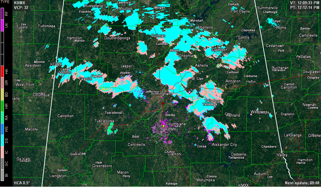
The teal color is dry snow, the pink color is ice crystals or snow grains. The green down in Tuscaloosa County was all rain.
Further north, a Winter Storm Warning is in effect for Madison, Jackson and DeKalb Counties where the colder air will be deeper and stay longer tonight. Decent ice accumulations of 0.2-0.3 inches could affect these areas along with one half inch of sleet and snow.
Sleet is being reported atop Monte Sano near Huntsville. Snow is being reported in Albertville, Scottsboro and Skyline. The City of Muscle Shoals is reporting most secondary roads are becoming treacherous. Primary roads (Woodward Av / Hwy 184 / Avalon Av) all are still passable. 1/10 of an inch of snow and sleet has accumulated near Florence. MSL airport reporting 1 1/12 miles viiibility in snow.
Town of Cherokee reports that secondary roadways are becoming slick north of town closer to the river. Heavy sleet being reported in downtown Cherokee at 12:28. A late report says that roads are reportedly becoming treacherous south of Cherokee at 12:34.
Numerous traffic accidents reported in Tishomingo County MS, which borders Colbert and Lauderdale Counties in NW Alabama. Tishomingo Co. is where Iuka is located.
In Middle Tennessee, an Ice Storm Warning is in effect for places like Nashville, Columbia, Cookeville, Crossville and Clarksville. One inch of snow and 1/4 to 1/2 inch of ice is expected in the Ice Storm Warning area. Much of the rest of Tennessee is under a Winter Storm Warning.
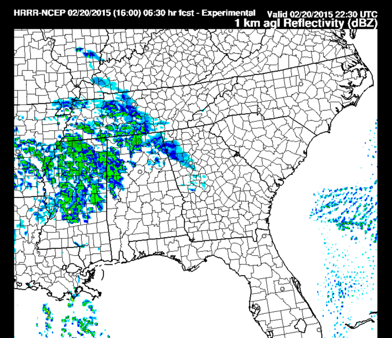
The precipitation should remain relatively light and north of US-82 through 4 p.m. Heavier precipitation will move into West Alabama by then, but temperatures should be profiling warmer with surface readings above freezing. Here is the High Resolution Rapid Refresh subhoulry simulated radar reflectivity at 4 p.m.
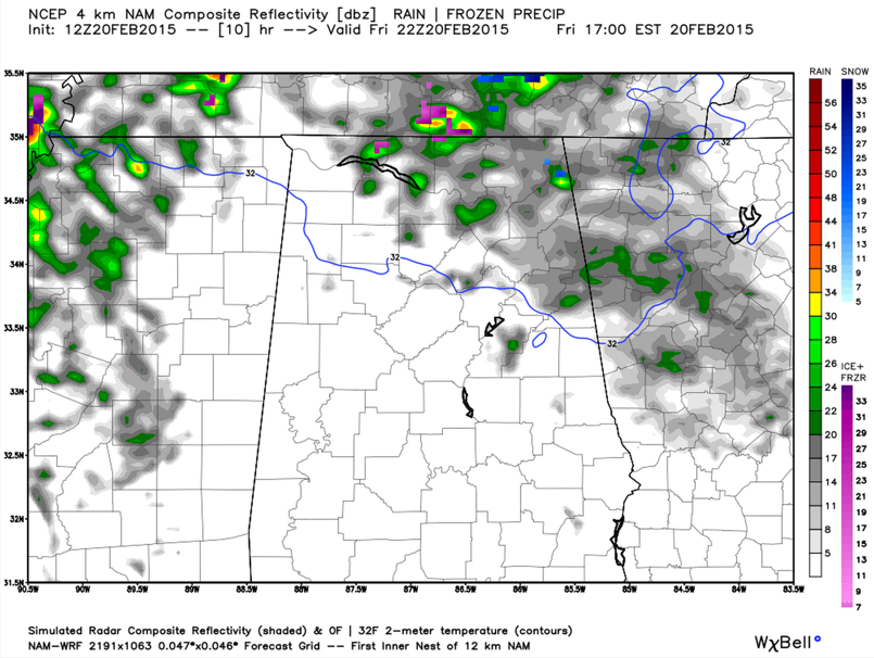
The 4 km NAM shows a good depiction of where the freezing line should be at the surface then.
ALABAMA POWER IS READY, ARE YOU? Our friends at Alabama Power are monitoring the forecast closely, ready to deploy people and assets to quickly address any outages that might occur. Read a special message from Ike Piggot about their commitment to their customers.
Category: Alabama's Weather, Winter Weather
About the Author (Author Profile)
Bill Murray is the President of The Weather Factory. He is the site's official weather historian and a weekend forecaster. He also anchors the site's severe weather coverage. Bill Murray is the proud holder of National Weather Association Digital Seal #0001 @wxhistorianSubscribe
If you enjoyed this article, subscribe to receive more just like it.


