

Early Afternoon Look at Model Data
We continue to carefully monitor the latest indications from models and synoptic data about the potential threat of wintry precipitations late tonight through early Monday morning and again early Tuesday morning.
Once again, these are low probability, low certainty but high impact events, so we have to take them very seriously. The high uncertainty means there is a high probability that the forecast will be wrong for many. It is the age old problem of forecasting winter weather in Central Alabama.
Snow is pushing across Oklahoma and northern Texas early this afternoon in association with a stronger upper level disturbance. This precipitation will continue southeastward through this afternoon and evening.
Further south and east, a mixed bag of precipitation will develop from west to east this afternoon into tonight. For Central and northern Arkansas, it will be snow. Across Northeast Texas, southern Arkansas, northern Louisiana, northern Mississippi and North and Central Alabama, a mix of freezing rain and sleet will fall.
For us in Central Alabama, the result will be a shield of mixed winter precipitation that will begin pushing across the area late tonight when temperatures are near or below freezing. This has triggered a winter weather advisory from the National Weather Service for tonight into early Monday morning. The devil is in the details as they, so let’s dig into some details.
Here is the current forecast thinking: Scattered showers will persist through the day in areas generally along and south of I-59, but there will be a few over northern sections as well. This activity will begin to pick up by sunset as that Texas disturbance moves this way. By midnight, the freezing line will be somewhere near US-28 from Hamilton to Gadsden and it will try to edge southward through the night. Freezing rain will be possible in areas from Marion and Lamar Counties across Fayette, Walker and Winston Counties through the pre-dawn hours. As the disturbance passes to our east after midnight, the colder air will begin to flood southward, bringing the freezing line with it. The freezing line will be into the I-59 corridor by sunrise, leading to a threat for freezing rain further south across Pickens and Tuscaloosa Counties across Jefferson, Blount, St. Clair, Etowah and Cherokee Counties.
The real threat is that the models aren’t handling the shallow cold air correctly, so everything comes with a caveat that the model output could be biased against freezing precipitation in this situation.
The NWS has issued a winter weather advisory for Fayette, Lamar, Marion, Walker and Winston Counties until 9 a.m. Monday and a freezing rain advisory for Blount, Cherokee, Etowah, Jefferson, Pickens, St. Clair and Tuscaloosa Counties.
From the NWS Birmingham website…
A “Winter Weather Advisory” is issued for a winter weather situation that causes significant inconveniences, but does not meet warning (see above) criteria. The winter weather can still be life threatening if caution is not exercised. A Winter Weather Advisory is issued if more than one type of hazardous winter weather is expected, is occurring, or is imminent:
• Sleet (ice pellets) accumulations of less than 1/2″
• Freezing rain/drizzle (ice) accumulations less than 1/4″
• Snowfall accumulations of 1/4″ to 2″ (A dusting of snow does not require an advisory)
A Freezing Rain Advisory is issued as part of a Winter Weather Advisory (WSW), with specific headlines within the WSW when ice accumulations of less than ¼ inch are expected.
To the north, the NWS in Huntsville has issued a Winter Weather Advisory until 9 a.m. Monday for for Colbert, Cullman, De Kalb, Franklin, Jackson, Lauderdale, Lawrence, Limestone, Madison, Marshall, Morgan [AL] till Feb 23, 9:00 AM CST
Now for the morning model data…
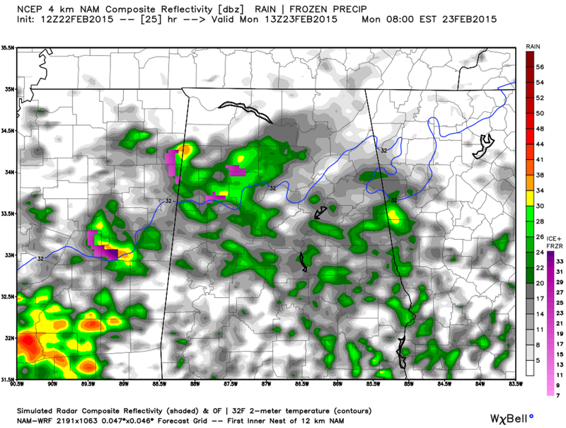
4 KM NAM
The 4 km NAM is on track with the forecast. It shows some freezing rain moving across the Tennessee Valley after midnight with the freezing line near US-278, dropping to a lie from Millport (Lamar County) to Moores Bridge (Tuscaloosa County) to Warrior and Clay (Jefferson County) to Gadsden and then along the DeKalb/Cherokee county line. Additional patches of freezing rain are embedded in the precipitation along and north of the freezing line, mainly across Lamar, Marion, Fayette, Walker and Winston Counties.
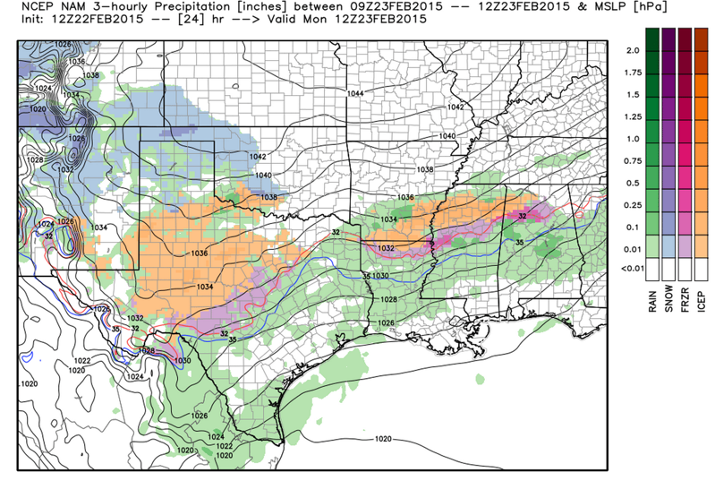
NAM
The NAM is a little more bullish on precipitation amounts and the intensity of freezing rain, especially across northern Lamar, Fayette, Walker, Cullman and northeastern Jefferson County.
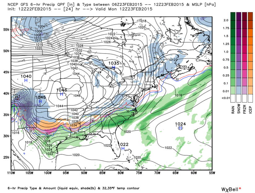
GFS
The American global model is right in line too.
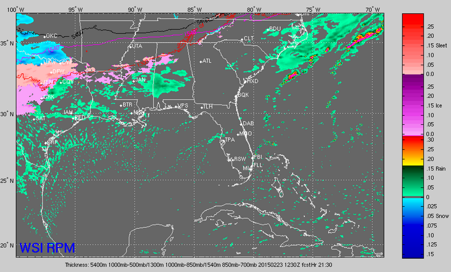
RPM
Basically in line as well.
MONDAY NIGHT
The GFS does not output much in the way of precipitation. Interestingly it does show a brief changeover to snow late Monday afternoon however. The 4km NAM shows a batch of precipitation moving across North Central Alabama late Monday afternoon and Monday night, with some embedded freezing rain, but no widespread problems. The NAM is much more bullish on freezing precip well down into the I-20 corridor during the evening and into the overnight.
BOTTOM LINE
This is a developing winter weather situation that will have to be monitored closely through the overnight and into Monday morning and again Monday evening and night. There will be travel problems in scattered areas it appears during the predawn hours up through 8-9 a.m. in parts of the advisory areas, most likely the winter weather advisory area, but folks in the freezing rain advisory area will have scattered problems.
ALABAMA POWER IS READY, ARE YOU? Our friends at Alabama Power are monitoring the forecast closely, ready to deploy people and assets to quickly address any outages that might occur. Read a special message from Ike Piggot about their commitment to their customers.
Category: Alabama's Weather, Winter Weather
About the Author (Author Profile)
Bill Murray is the President of The Weather Factory. He is the site's official weather historian and a weekend forecaster. He also anchors the site's severe weather coverage. Bill Murray is the proud holder of National Weather Association Digital Seal #0001 @wxhistorianSubscribe
If you enjoyed this article, subscribe to receive more just like it.


