

Icy Travel Tonight; Snow Wednesday
An all new edition of the ABC 33/40 Weather Xtreme video is available in the player on the right sidebar of the blog. You can subscribe to the Weather Xtreme video on iTunes by clicking here.
COMPLEX WINTER WEATHER PATTERN: With two events coming up over the next 3 days, including a possible high impact event Wednesday, I again encourage you first to read the things you need to understand about winter weather forecasts. All 10 points are very important.
TONIGHT/TOMORROW MORNING: A winter weather advisory is up for tonight and tomorrow morning as freezing rain threatens to bring some icy travel. Sleet and snow is now falling over parts of Northwest Alabama…
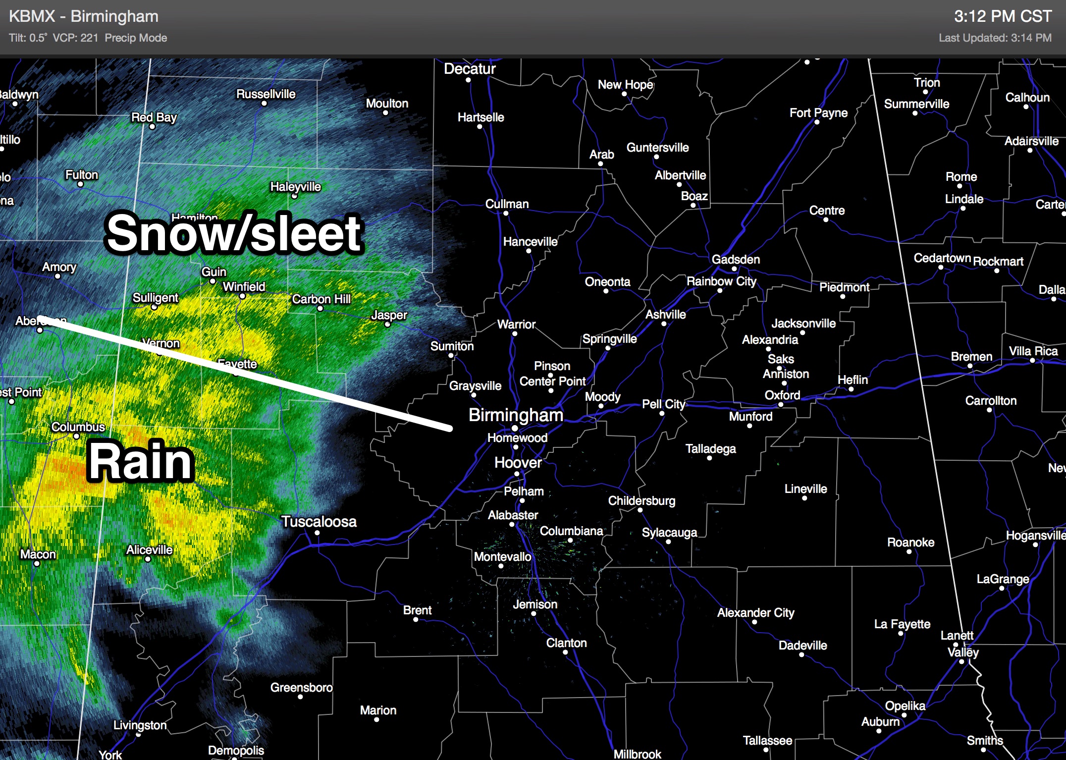
This will precipitation will continue to expand and move east. We have heard of some icing already on bridges in Marion County near the Mississippi state line, and icy travel is a possibility over Northwest Alabama from now through the night, where temperatures are already below freezing.
The freeze line will slowly drop south tonight, and will be down to the I-20 corridor by 12:00 midnight-3:00 a.m. Then, by daybreak tomorrow, the freeze line will be as far south as Demopolis, Marion, Clanton, Rockford, and Roanoke.
Along and north of the freeze line icy travel is very possible, if not likely tonight. Most school systems have delayed their opening tomorrow; temperatures should rise above freezing by 9:00 a.m. tomorrow.
We see no weather related issues tomorrow afternoon or tomorrow night.
SNOW POTENTIAL WEDNESDAY: The latest model runs are still on board, the using a conservative ensemble approach, snow amounts of 2 to 4 inches look likely across North/Central Alabama Wednesday, with isolated amounts to 8 inches.
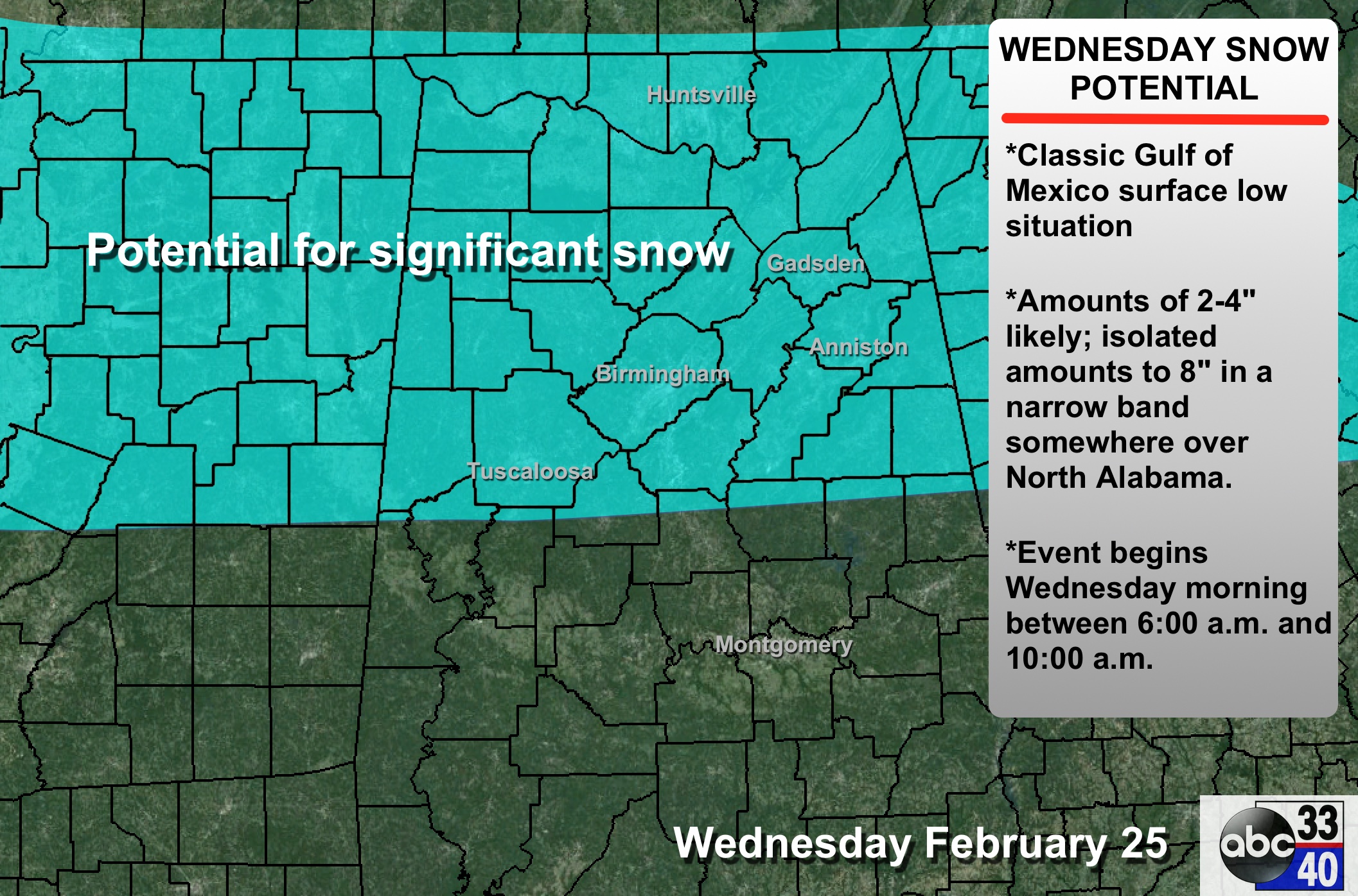
TIMING: The snow should begin sometime between 6:00 and 10:00 Wednesday morning, and continue through the day into Wednesday evening.
PLACEMENT: The greatest chance of snow Wednesday is along and north of a line from Eutaw to Brent to Jemison to Roanoke. Some snow is possible south of this line, but amounts should be small. Precipitation will be rain over the southern half of Alabama. There should be a strip of heavier snow within a deformation axis that is about 30 to 40 miles wide, but there is no way we can resolve that at this point. Within that small strip, some 8 inch totals are possible.
IMPACT: This will impact travel in a big way, and icy/dangerous travel is likely Wednesday, Wednesday night, and into Thursday morning. Scattered power outages are possible where heavier, wet snow develops.
Remember, this forecast can, and most likely will change as we get closer to the event.
THURSDAY THROUGH THE WEEKEND: For now the weather looks dry with a slow warming trend; we should reach the 50s by Saturday and Sunday. See the Weather Xtreme video for maps, graphics, and more details.
ALABAMA POWER IS READY, ARE YOU? Our friends at Alabama Power are monitoring the forecast closely, ready to deploy people and assets to quickly address any outages that might occur. Read a special message from Ike Pigott about their commitment to their customers.
WEATHER BRAINS: Don’t forget you can listen to our weekly 90 minute netcast anytime on the web, or on iTunes. This is the show all about weather featuring many familiar voices, including our meteorologists here at ABC 33/40. We will produce this week’s show tonight at 8:30 CT… you can watch it on “James Spann 24/7” on cable systems around the state, or on the web here.
CONNECT: You can find me on all of the major social networks…
Facebook
Twitter
Google Plus
Instagram
I had a great time today visiting with the kids at Northington Elementary in Tuscaloosa, and Eden Elementary in Pell City. Be looking for them on the Pepsi KIDCAM today at 5:00 on ABC 33/40 News! More updates to come later tonight… stay tuned…
Category: Alabama's Weather
About the Author (Author Profile)
James Spann is one of the most recognized and trusted television meteorologists in the industry. He holds the AMS CCM designation and television seals from the AMS and NWA. He is a past winner of the Broadcast Meteorologist of the Year from both professional organizations.Subscribe
If you enjoyed this article, subscribe to receive more just like it.


