

Patchy Ice This Morning; Snow Tomorrow
An all new edition of the ABC 33/40 Weather Xtreme video is available in the player on the right sidebar of the blog. You can subscribe to the Weather Xtreme video on iTunes by clicking here.
Before we dive into the details of what to expect over the next 72 hours… please read the “10 things you need to know about winter weather forecasts”, and take some time to watch the Weather Xtreme video for the maps and graphics.
THIS MORNING: Freezing rain/drizzle and sleet continues in scattered spots. There is icy travel; one report indicates Alabama Highway 69 between Jasper and Cullman is very icy and dangerous, but in other spots roads are not as bad. A winter weather advisory remains in effect with the freeze line now down to I-20; if you drive this morning, be very careful. One stretch of highway might be dry, but you can run up on ice in a heartbeat. Temperatures rise above freezing by 9:00 a.m. and ice issues will fade.
THIS AFTERNOON/TONIGHT: The calm before the storm. Mostly cloudy, no precipitation, no driving issues.
POTENTIAL FOR A MAJOR SNOW EVENT TOMORROW: A winter storm watch remains in effect for roughly the northern half of Alabama tomorrow.
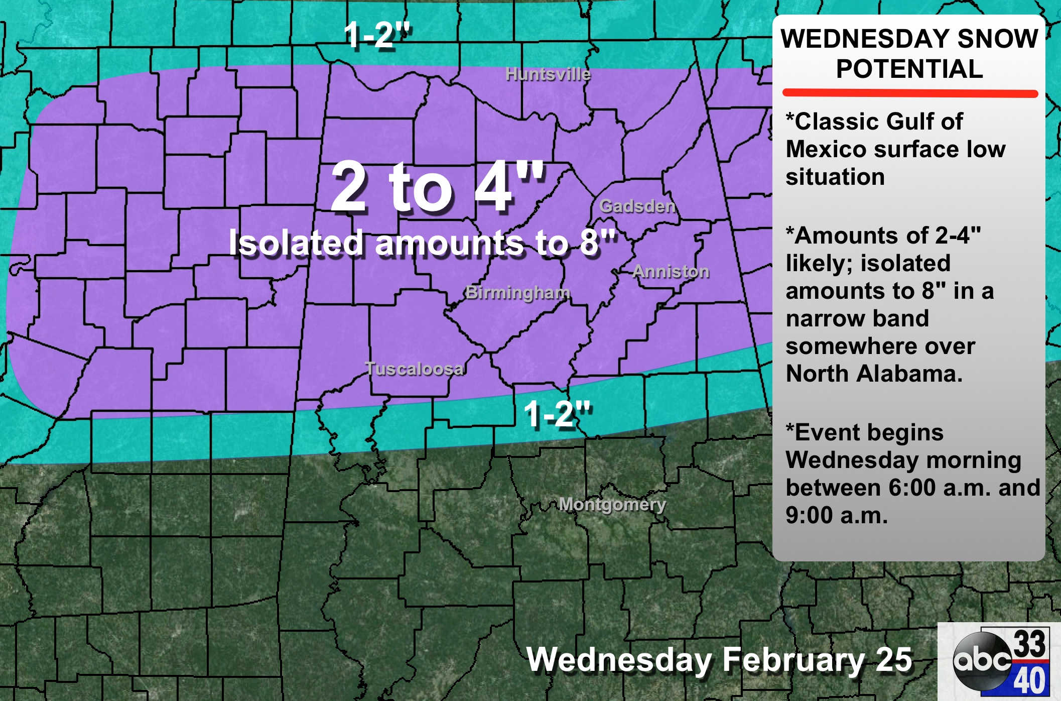
TIMING: Snow should begin sometime between 6:00 and 9:00 a.m. Snow intensity will increase during the afternoon before ending tomorrow night.
PLACEMENT: The difficult part of the forecast is defining the boundary (which should be well below I-20) between snow and rain. For now it looks to be close to a line from Emelle to Forkland to Greensboro to Clanton to Alex City to Lafayette.
ACCUMULATION: The average accumulation potential is 2 to 4 inches. With a classic Gulf of Mexico low like this, there is usually a deformation axis that sets up a narrow band of heavier snow, but defining that is impossible now. The heavy snow band is usually about 30 miles wide, and where that sets up isolated amounts to 8 inches are possible. Some thundersnow within that axis is not out of the question.
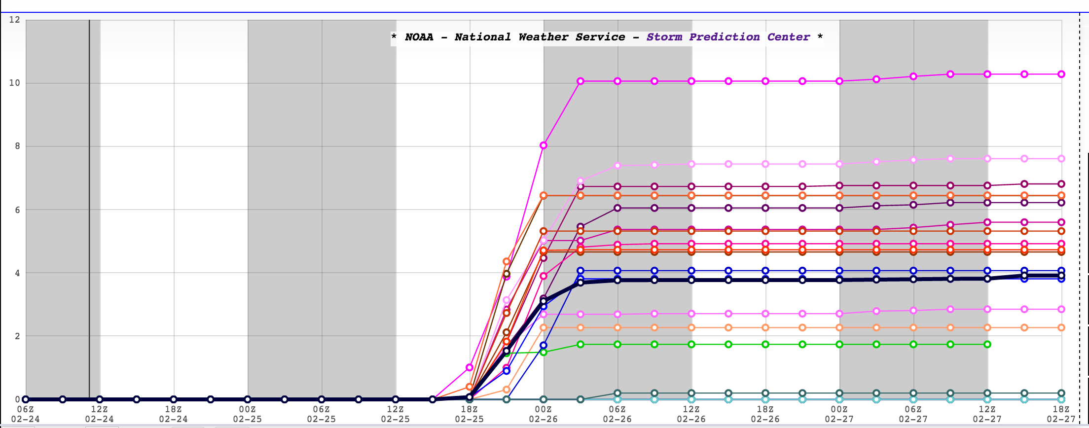
BOOM/BUST: Using the SREF ensemble, one member is printing 10 inches for Birmingham. On the “bust” end, two members are under 1/2 inch. Most of the members are between 2 and 8 inches; in line with our forecast.
IMPACT: Travel will be severely impacted, and where heavy, wet snow falls, there could be scattered power outages. Travel issues will likely persist into Thursday morning.
CONFIDENCE: Model agreement is excellent, and confidence is high. However, there is never a guarantee. And, with any event like this there will be surprises. Some will be very happy with the snow they get, others disappointed.
REMEMBER: This forecast can, and probably will change. Check the blog often for updates and new discussions.
THURSDAY/FRIDAY: These two days will be dry with highs in the 40s, allowing for snow melting.
THE ALABAMA WEEKEND: We go back in the 50s Saturday and Sunday; Saturday should be partly to mostly sunny… we will mention the chance of a little scattered light rain Sunday, but nothing too widespread or heavy.
NEXT WEEK: We warm into the 60s Monday and Tuesday; a surface low will pass northwest of the state, and could bring the threat of strong storms Tuesday afternoon or Tuesday night. Keep in mind Sunday is March 1, the beginning of the spring severe weather season in Alabama. No dull moments around here.
ALABAMA POWER IS READY, ARE YOU? Our friends at Alabama Power are monitoring the forecast closely, ready to deploy people and assets to quickly address any outages that might occur. Read a special message from Ike Pigott about their commitment to their customers.
WEATHER BRAINS: Don’t forget you can listen to our weekly 90 minute netcast anytime on the web, or on iTunes. This is the show all about weather featuring many familiar voices, including our meteorologists here at ABC 33/40. Scroll down for the show notes on the new episode we recorded last night.
CONNECT: You can find me on all of the major social networks…
Facebook
Twitter
Google Plus
Instagram
Look for frequent updates through the day… the next Weather Xtreme video will be posted by 4:00 or so this afternoon.
Category: Alabama's Weather
About the Author (Author Profile)
James Spann is one of the most recognized and trusted television meteorologists in the industry. He holds the AMS CCM designation and television seals from the AMS and NWA. He is a past winner of the Broadcast Meteorologist of the Year from both professional organizations.Subscribe
If you enjoyed this article, subscribe to receive more just like it.


Comments (9)
Trackback URL | Comments RSS Feed
Sites That Link to this Post