

Snow Accumulation Reports
The blue icons show snow depth storm reports from the National Weather Service.
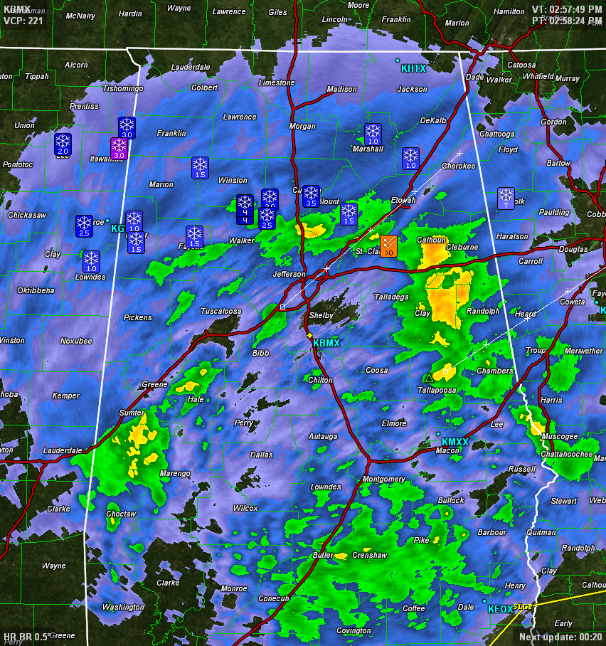
COUNTY BY COUNTY
ST CLAIR
Numerous wrecks on I-59 between Argo and Springville
WALKER
4 inches of snow 7 and 10 miles north of Jasper
Many wrecks in Jasper
CULLMAN
3.5 inches of snow in Hanceville
BLOUNT
1.8 inches at Oneonta
ETOWAH
All roads impassable
FAYETTE
1.5″ at Fowlers Crossroads
LAMAR
1″ in Sulligent
1.5″ in Vernon
WINSTON
All roads closed
MARSHALL
All roads impassable in Arab
MISC
…Scott Martin reports he just heard thunder in Fultondale. The NWS BMX reports several reports of thunder in Corner (northern Jefferson County).
THE LOW
The low responsible for the snow is in the Gulf of Mexico south of Mobile. The back edge of the precipitation is approaching the Mississippi River, so we have a long way to go.
STORMS
There are strong thunderstorms over southern Mississippi and Alabama. Small hail was report with the storm near Waynesboro MS. It will move into Choctaw and Clarke Counties in Southwest Alabama.
ALABAMA POWER IS READY, ARE YOU? Our friends at Alabama Power are monitoring the forecast closely, ready to deploy people and assets to quickly address any outages that might occur. Read a special message from Ike Pigott about their commitment to their customers.
Stay tuned for more updates…
Category: Alabama's Weather, Winter Weather
About the Author (Author Profile)
Bill Murray is the President of The Weather Factory. He is the site's official weather historian and a weekend forecaster. He also anchors the site's severe weather coverage. Bill Murray is the proud holder of National Weather Association Digital Seal #0001 @wxhistorianSubscribe
If you enjoyed this article, subscribe to receive more just like it.


