

Dry Through Tomorrow
An all new edition of the ABC 33/40 Weather Xtreme video is available in the player on the right sidebar of the blog. You can subscribe to the Weather Xtreme video on iTunes by clicking here.
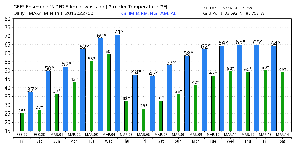
COLD, DRY FRIDAY: A secondary surge of colder air is moving into Alabama today; the high will be around 40, and many communities north of Birmingham won’t get out of the 30s. We expect intervals of sunshine, and the day will be dry.
OUR WEEKEND: Saturday will be warmer; we will forecast a mix of sun and clouds with a high in the 52 to 55 degree range. Still below average (the average high for February 28 is 62)… but at least we are moving in the right direction. Sunday will be mostly cloudy day with a chance of scattered light rain as moisture returns. Nothing heavy or widespread, but no doubt some rain is possible during the day. Also, a CAD (cold air damming) setup could bring colder air into East Alabama; the high Sunday will vary from the mid 40s near the Georgia border to the upper 50s near the Mississippi border.
NEXT WEEK: The wedge breaks down Monday and our high will be close to 60. A cold front approaching from the north should bring occasional showers; maybe some thunder. Tuesday will be the warmest day of the week as an upper ridge creeps in here from the south; the GFS is now printing a high of 74 for Birmingham. A deep surface low will run through the Great Plains; we will need to monitor for the potential of strong/severe thunderstorms, but at the moment it looks like the best dynamic forcing will be a little north and west of our state. Best chance of showers/storms Tuesday will come over the northern counties; South Alabama will be dry thanks to the ridge, and communities south of Montgomery could very well approach 80 degrees.
The front creeps through Wednesday as the chance of rain continues; some global model runs have suggested a pretty good wave will run along the front, enhancing the coverage of rain. I figure rain amounts of 2 to 3 inches are likely Monday through Wednesday.
Much colder air returns Thursday; if you believe the 06Z GFS we won’t get of the 30s, and it even hints at some risk of wintry precipitation early in the day. See the Weather Xtreme video for maps, graphics, and more details.
WEATHER BRAINS: Don’t forget you can listen to our weekly 90 minute netcast anytime on the web, or on iTunes. This is the show all about weather featuring many familiar voices, including our meteorologists here at ABC 33/40.
CONNECT: You can find me on all of the major social networks…
Facebook
Twitter
Google Plus
Instagram
I have weather programs today at Oak Grove Elementary in Jefferson County, and West Blocton Elementary in Bibb County… look for the next Weather Xtreme video here by 4:00 this afternoon. Enjoy the day!
Category: Alabama's Weather
About the Author (Author Profile)
James Spann is one of the most recognized and trusted television meteorologists in the industry. He holds the AMS CCM designation and television seals from the AMS and NWA. He is a past winner of the Broadcast Meteorologist of the Year from both professional organizations.Subscribe
If you enjoyed this article, subscribe to receive more just like it.


