

70s Tomorrow; Ice Thursday
An all new edition of the ABC 33/40 Weather Xtreme video is available in the player on the right sidebar of the blog. You can subscribe to the Weather Xtreme video on iTunes by clicking here.
WILD WEATHER SWINGS: A warm front is moving through North Alabama this afternoon; south of the front temperatures are nearing 80 over the southeast corner of the state; on the north side readings are in the 50s over the Tennessee Valley of North Alabama.
All of the state gets in the warm air tomorrow with highs generally in the 70-75 degree range. A few showers are possible during the day, but they will be scattered in nature and it certainly won’t rain all day. The most widespread rain comes tomorrow night as the Arctic front approaches.
Thunderstorms could be involved, but organized severe weather is not expected around here. We do note SPC has a “marginal” severe weather risk defined over parts of Central Mississippi and far West-Central Alabama for late tomorrow and tomorrow night.
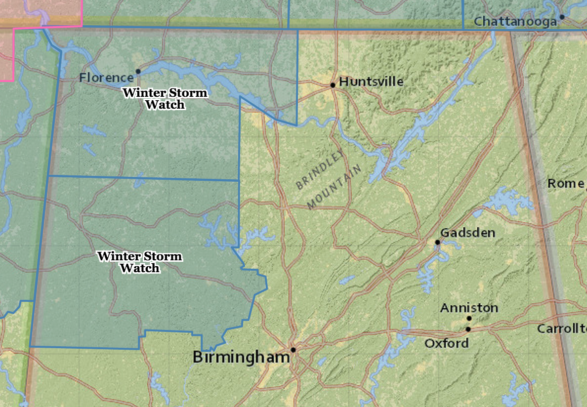
WINTER STORM WATCH: NWS offices in Birmingham and Huntsville have issued a winter storm watch for parts of North and West Alabama for Thursday, as Arctic air spills into the state and an upper trough approaches from the west. The winter storm watches are generally west of I-65, and north of a line from Millport to Dora/Sumiton, where ice accumulation is expected to exceed 0.25″.
TIMING: The freeze line should be near Muscle Shoals at midnight tomorrow night… near Cullman at 4:00 a.m. Thursday… I-59 (Birmingham, Tuscaloosa, Gadsden) at 7:00 a.m…. and Anniston at 8:00 a.m. Understand these are approximate times and could change.
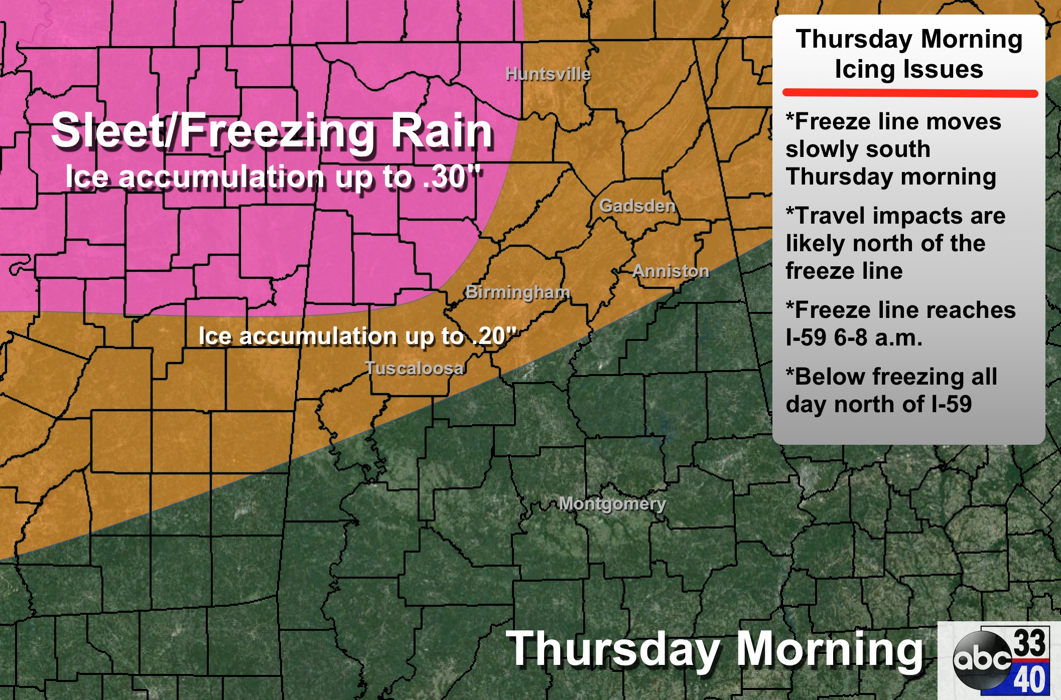
PLACEMENT: Some icing is possible as far south as a line from Eutaw to Chelsea to Heflin during the day Thursday as the freeze line keeps moving south. The most significant ice accumulation will be north of I-59.
As usual, Tuscaloosa, Birmingham, Anniston, and Gadsden are on the border between rain and freezing rain, but models are in decent agreement that the freeze line will slip a little south of these cities by 8:00 Thursday morning, and icy travel is a very real possibility there.
PRECIPITATION TYPE: Most of this event Thursday morning will feature freezing rain (rain in liquid form that falls with surface temperatures below 32) and sleet (ice pellets); snow flurries are possible Thursday afternoon as the event winds down.
ACCUMULATION: Ice accumulation up to 0.30″ is possible in the winter storm watch areas (west of I-65, and north of a line from Millport to Dora/Sumiton). Elsewhere, amounts will vary from very little to 0.20″. For now significant snow accumulation is not expected with just light flurries on top of the ice.
IMPACT: Where freezing rain falls, travel conditions will become icy and dangerous. Also, where 0.25″ of ice or more accumulates, scattered power outages are possible due to the weight of the ice on trees and power lines, and a north wind of 10-20 mph.
DURATION: Temperatures will stay below freezing all day generally north of I-59, meaning icy travel could continue through the day Thursday, Thursday night, and possibly into Friday morning. Temperatures warm above freezing by mid-morning Friday when conditions will improve greatly.
REMEMBER: This forecast can, and will change. Check the blog for updates as we get closer.
FRIDAY AND THE WEEKEND: These three days will be dry, with partly sunny days and fair nights. We reach the upper 40s Friday afternoon, with mid 50s Saturday and Sunday.
Take some time to watch the Weather Xtreme video for the maps, graphics, and more details.
WEATHER BRAINS: Don’t forget you can listen to our weekly 90 minute netcast anytime on the web, or on iTunes. This is the show all about weather featuring many familiar voices, including our meteorologists here at ABC 33/40.
CONNECT: You can find me on all of the major social networks…
Facebook
Twitter
Google Plus
Instagram
I had a great time today seeing the kids at Randolph Elementary in Bibb County… be looking for them on the Pepsi KIDCAM today at 5:00 on ABC 33/40 News! The next Weather Xtreme video will be posted here by 7:00 a.m. tomorrow…
Category: Hodgepodge
About the Author (Author Profile)
James Spann is one of the most recognized and trusted television meteorologists in the industry. He holds the AMS CCM designation and television seals from the AMS and NWA. He is a past winner of the Broadcast Meteorologist of the Year from both professional organizations.Subscribe
If you enjoyed this article, subscribe to receive more just like it.


