

Warm Today; Icy Tomorrow
An all new edition of the ABC 33/40 Weather Xtreme video is available in the player on the right sidebar of the blog. You can subscribe to the Weather Xtreme video on iTunes by clicking here.
INTO THE 70s TODAY: We are projecting a high in the 72-76 degree range across North/Central Alabama today with dewpoints up in the 60s. A decent part of the day will be dry, although a few scattered showers could pop up at times.
The air has that “tornado” feel to it, but the good news is that no severe weather is expected with the Arctic front approaching late tonight. SPC has defined no severe weather areas, and parameters don’t favor any problems. We do expect an increase in rain tonight, with some thunder, as the front gets closer.
ICY MESS TOMORROW: Temperatures will fall steadily during the morning hours tomorrow, and where surface readings go below freezing, freezing rain and sleet will lead to icing problems. NWS offices in Birmingham and Huntsville have issued winter storm watches for a number of North Alabama counties, where ice accumulation is expected to be greater than 0.25″…
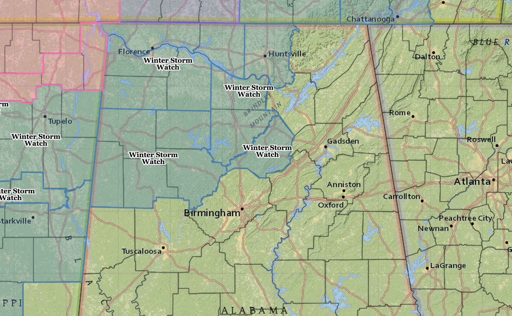
Understand, there will be icing issues in counties not in the winter storm watch; the amounts will just be smaller.
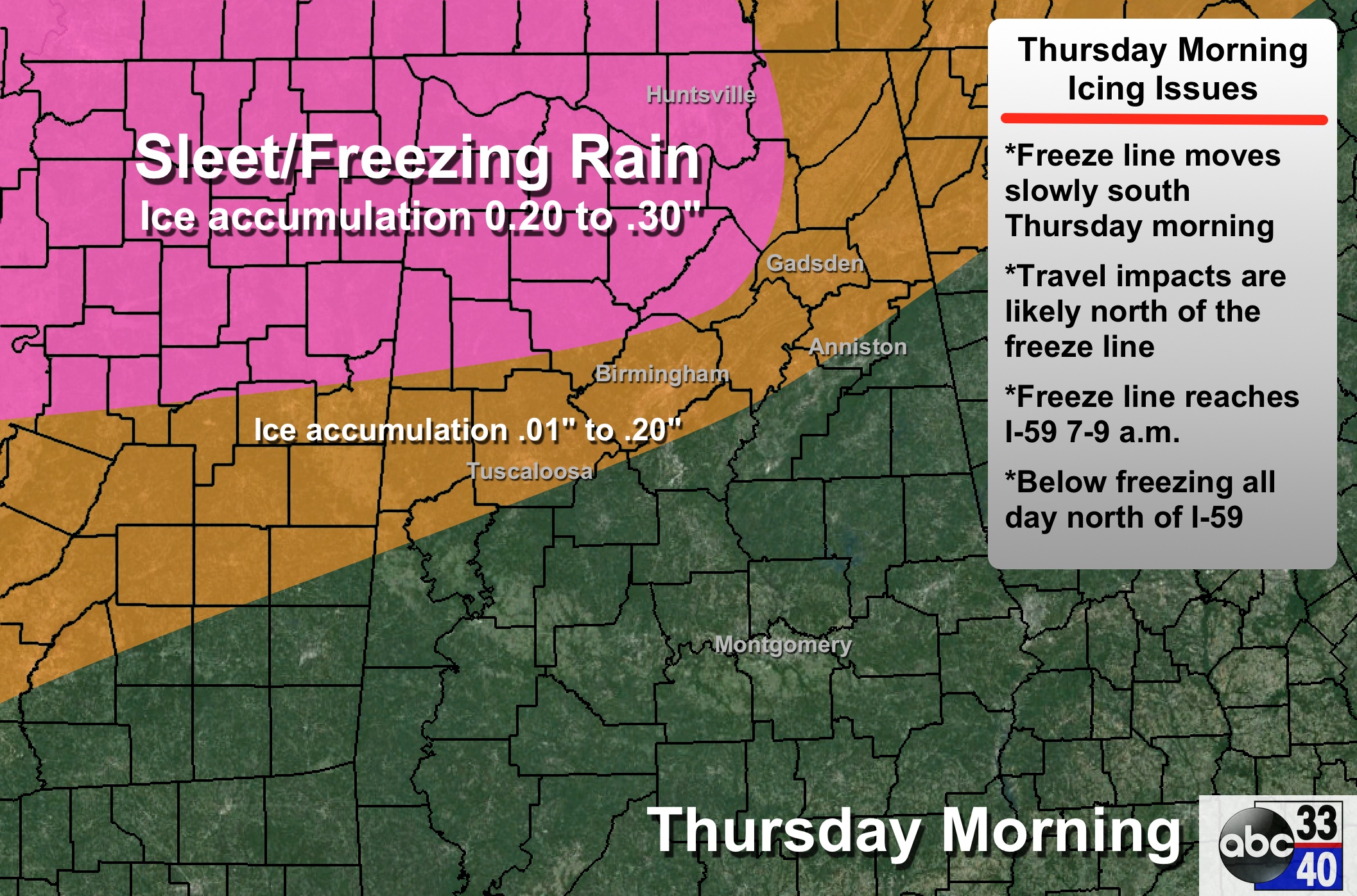
PRECIPITATION TYPE: The cold air will be shallow, so most of the event will feature freezing rain (liquid that falls with temperatures at or below 32 degrees) and sleet (ice pellets). Some light snow is possible as it winds down.
ACCUMULATION: Ice accumulation of 0.20″ to 0.30″ is likely in the winter storm watch areas; amounts of 0.01″ to 0.20″ are expected down to Tuscaloosa, Birmingham, and Gadsden.
TIMING: Surface temperatures will drop below freezing at approximately these times…
Florence/Muscle Shoals/Huntsville 1:00 a.m. to 3:00 a.m.
Fayette/Cullman/Scottsboro 4:00 a.m. to 6:00 a.m.
Tuscaloosa/Birmingham/Gadsden 7:00 a.m. to 9:00 a.m.
Anniston: Very close call; temperatures could reach 32 by late morning around 11:00 a.m., but there is also a chance Anniston stays above freezing during the event.
So, understand if you are in the Birmingham metro, it should be in the mid 30s with only a cold rain at 6:00 to 7:00 a.m. Temperatures should drop below freezing by 9:00 a.m., when icing issues will begin.
PLACEMENT: The southern edge of the icing extent should be roughly on a line from Eutaw to Chelsea to Anniston.
IMPACT: One mitigating factor is the warm weather we are enjoying today; the main issues will be ice on bridges and overpasses, which will greatly impact travel. Also, where we see over 0.25″ of ice accumulation on trees and power lines, some scattered power outages are possible thanks to a north wind of 10-20 mph.
DURATION: Many communities north of I-59 will stay below freezing all day tomorrow, so icy travel could linger into tomorrow night and Friday morning. Temperatures go above freezing at mid-morning Friday, and there will be quick improvement.
REMEMBER: This forecast can, and will change. If you don’t check updates later today and tonight, you will be working with old information that isn’t helpful. And, expect surprises; winter weather forecasts in Alabama are always a challenge, and with a freezing rain event they are especially complex.
FRIDAY AND THE WEEKEND: These three days will be dry; we warm into the upper 40s Friday, and then we expect a high in the 55-59 degree range Saturday and Sunday. High clouds could move in Sunday, and a bit of rain is possible late in the weekend over far South Alabama, but not on our end of the state.
NEXT WEEK: The 06Z GFS brings in the next chance of rain on Tuesday… see the Weather Xtreme video for maps, graphics, and more details.
WEATHER BRAINS: Don’t forget you can listen to our weekly 90 minute netcast anytime on the web, or on iTunes. This is the show all about weather featuring many familiar voices, including our meteorologists here at ABC 33/40.
CONNECT: You can find me on all of the major social networks…
Facebook
Twitter
Google Plus
Instagram
I will be doing a weather program today at Chelsea Park Elementary School in Shelby County… be looking for the next Weather Xtreme video here by 4:00 this afternoon… enjoy the day!
Category: Alabama's Weather
About the Author (Author Profile)
James Spann is one of the most recognized and trusted television meteorologists in the industry. He holds the AMS CCM designation and television seals from the AMS and NWA. He is a past winner of the Broadcast Meteorologist of the Year from both professional organizations.Subscribe
If you enjoyed this article, subscribe to receive more just like it.


