

Rain and Storms Pushing Through Central Alabama
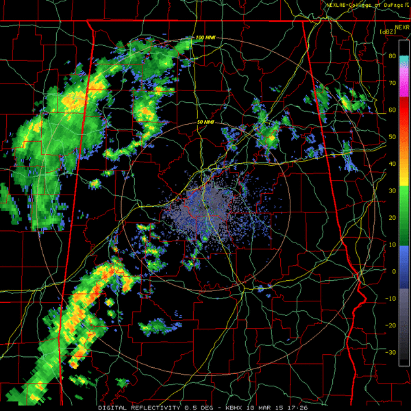
An area of rain and some thunderstorms has developed over southeastern Mississippi and West Alabama. It is moving northeast, tracking along and just south of I-59. The storms are located along the southern periphery of the precipitation area, drawing on slightly unstable air to the south where temperatures have soared into the 70s and 80s. CAPE values are running over 1,000 j/kg in the warmer air.
It is 82F at Montgomery this hour. The record high there is 86F for today.
The strongest storms are from west of Centreville to west of Marion to east of Linden in Marengo County. They are not severe, but could produce some strong wind gusts. Can’t rule out an isolated severe storm until the storms get into slightly cooler air up over Shelby County and points northeast, but the chance looks small.
The thunderstorm activity will track northeast, affecting mainly Bibb, Marion and Dallas Counties moving into Shelby, Chilton and Autauga Counties over the next hour. There could be some thunder over southern Jefferson County as well, south of I-459. Rain will impact areas along I-59 from the Tuscaloosa area on to the northeast through the Birmingham Metro.
Scroll down for James’ complete update on the forecast
Category: Alabama's Weather, Severe Weather
About the Author (Author Profile)
Bill Murray is the President of The Weather Factory. He is the site's official weather historian and a weekend forecaster. He also anchors the site's severe weather coverage. Bill Murray is the proud holder of National Weather Association Digital Seal #0001 @wxhistorianSubscribe
If you enjoyed this article, subscribe to receive more just like it.


