

Another Surge Of Rain Ahead
An all new edition of the ABC 33/40 Weather Xtreme video is available in the player on the right sidebar of the blog. You can subscribe to the Weather Xtreme video on iTunes by clicking here.
EARLY THIS MORNING: The northern half of Alabama had a nice break in the rain late yesterday and last night, but the wet weather is far from over. New showers are forming quickly over West Alabama early this morning, and rain will become widespread this afternoon and tonight as a surface low forms west of the state, and higher dewpoints are pulled northward.
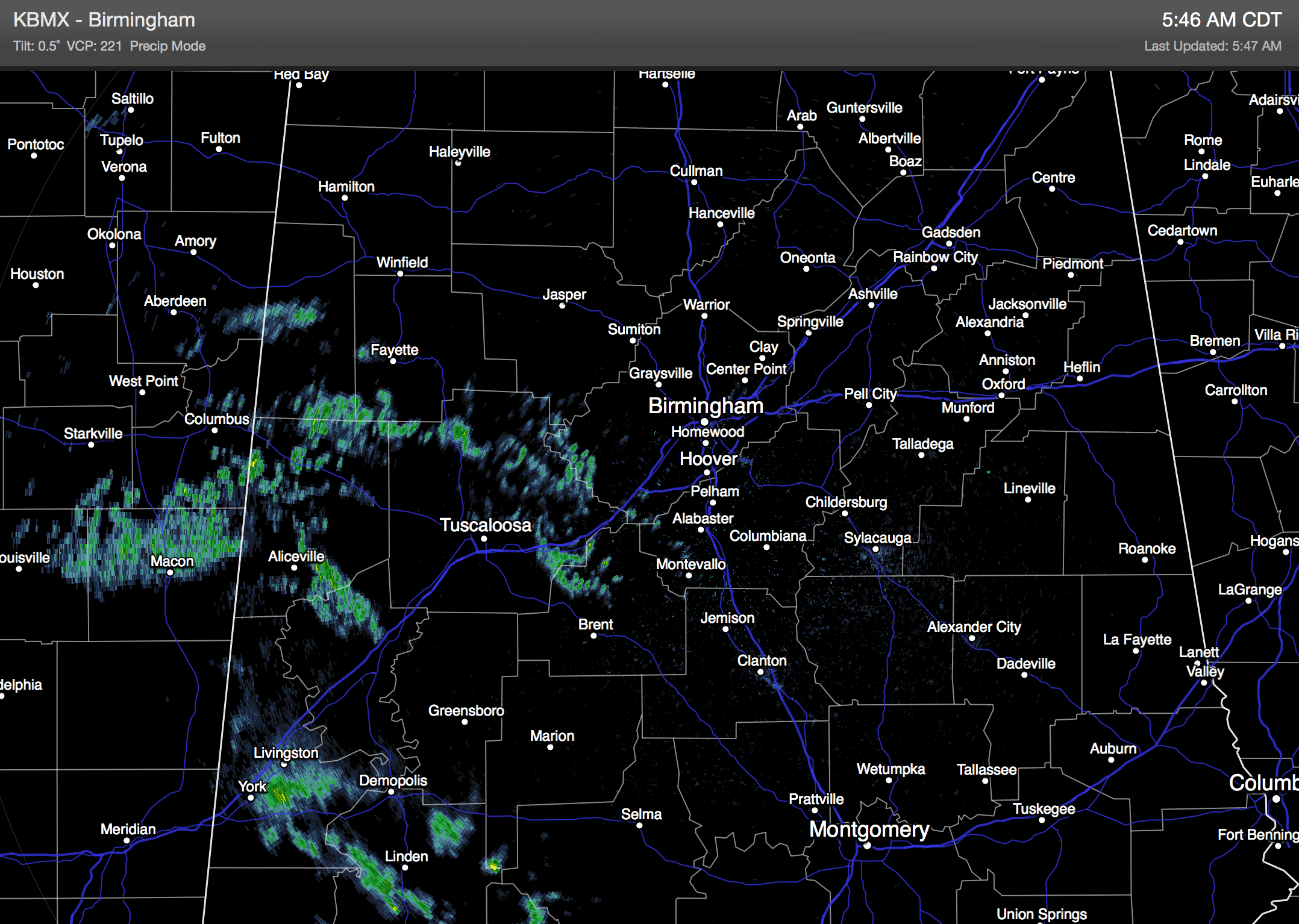
A few thunderstorms are possible, but no severe weather is expected in Alabama. We note SPC does have a “marginal” severe weather risk defined for parts of Southwest Mississippi and Louisiana later today and tonight.
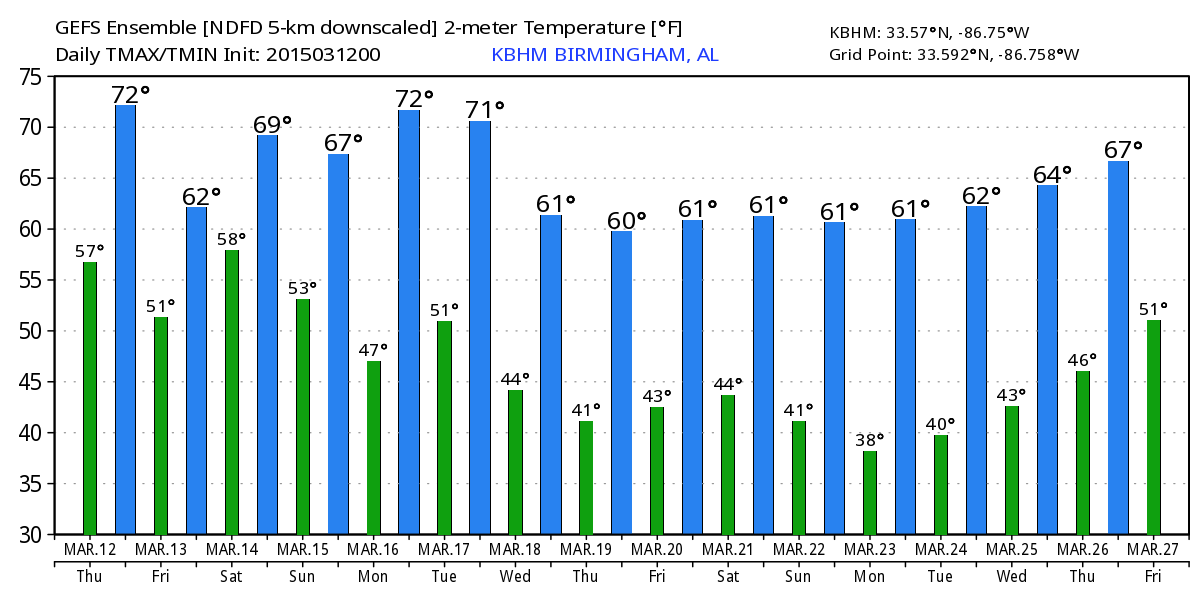
COOLER TOMORROW: A cool easterly flow will keep temperatures in the 50s over East Alabama tomorrow; 60s are likely for the western side of the state. And, it will rain a good part of the day. Additional rain amounts of 1-2″ are expected by tomorrow night, not enough to create any really significant flooding issues, although we do note the NWS Huntsville has issue an “areal flood watch” for Colbert, Franklin, Lauderdale, Lawrence, Limestone, Madison, and Morgan Counties of North Alabama. The cool air tomorrow means stable conditions and no risk of severe storms, and probably no thunder.
THE ALABAMA WEEKEND: We will hang on to the chance of a few lingering showers Saturday morning, but drier air begins to arrive later in the day, and we might even see a few intervals of sunshine by Saturday afternoon with a high in the low 70s. Then, Sunday will be dry with a partly sunny sky… the high will be close to 70 degrees.
NEXT WEEK: Dry weather continues for the first half of the week, then rain will return late Thursday into Friday ahead of a cold front. Then, colder air will settle into the state for the following weekend (March 21-22)… we could see some frost, or maybe a late season freeze around that time. Keep in mind the average date of the last freeze (for Birmingham) is March 26, and we have experienced a freeze as late as April 23. See the Weather Xtreme video for maps, graphics, and more details.
FIRST ALERT STORM TEAM TOUR: Our annual severe weather awareness tour across Alabama rolls along; we will be in Greensboro this evening. Just drop by anytime from 4:00 until 6:30… you can watch me do weather live on ABC 33/40, get some free stuff to take home, and have a chance to win several NOAA Weather Radios we will be giving away. If you need your weather radio programmed or checked, bring it by and we will be glad to help.
WEATHER BRAINS: Don’t forget you can listen to our weekly 90 minute netcast anytime on the web, or on iTunes. This is the show all about weather featuring many familiar voices, including our meteorologists here at ABC 33/40.
CONNECT: You can find me on all of the major social networks…
Facebook
Twitter
Google Plus
Instagram
I will be speaking at the Alabama Natural Gas Association this morning in Hoover… due to travel I won’t be able to produce an afternoon video today, but I will have updated forecast notes here by 4:00. Enjoy the day!
Category: Alabama's Weather
About the Author (Author Profile)
James Spann is one of the most recognized and trusted television meteorologists in the industry. He holds the AMS CCM designation and television seals from the AMS and NWA. He is a past winner of the Broadcast Meteorologist of the Year from both professional organizations.Subscribe
If you enjoyed this article, subscribe to receive more just like it.


