Warm Again Today; Clouds Return Tonight
An all new edition of the ABC 33/40 Weather Xtreme video is available in the player on the right sidebar of the blog. You can subscribe to the Weather Xtreme video on iTunes by clicking here.
ANOTHER WARM DAY FOR MID-MARCH: We project a high around 80 degrees again today; yesterday’s official high in Birmingham was 81 degrees… the first high at or over 80 degrees in 2015, 14 degrees above average, and within 4 degrees of the record high for March 16, 85 degrees set in 2012.
The record high for today is 86 degrees set in 1963… we won’t break it, but we could get within 5 degrees or so. The air is dry and the sky today will be partly sunny.
CHANGES AHEAD: A cold front will pass through North Alabama this evening, and clouds will push down into the state tonight along with the cooler air. A shower can’t be ruled out early tonight over the northeast corner of the state, but the risk seems very low. We will drop down to near 50 degrees by early tomorrow.
Tomorrow will be mostly cloudy with a high in the upper 60s, and some rain should begin to push into West Alabama by mid to late afternoon. That becomes widespread tomorrow night, making the beginning of a multiple day period of unsettled weather.
THURSDAY/FRIDAY: Models are having a difficult time resolving this active pattern, and we are getting a different look from the GFS this morning. Looks like rain from the lead impulse will taper off Thursday morning, and there could be a break in the wet weather Thursday afternoon and Thursday night, although some patches of light rain sure can’t be ruled out. Then, another wave will bring a chance of more rain during the day Friday and Friday night. The rain won’t be continuous, but it could rain at any time.
Highs will be in the 60s, and there is no risk of severe weather, and we probably won’t have much thunder at all.
THE ALABAMA WEEKEND: We will need to adjust the forecast to include a chance of some light rain Saturday and Saturday night. Initially global models hinted at rain-free weather for the northern half of the state over the weekend, but the GFS is clearly trending wetter for Saturday. Again, the rain won’t be continuous, and day won’t be a total “wash-out”, but understand there will be a chance of rain at times.
Sunday still looks rain-free with a partly sunny sky. Highs over the weekend will remain in the 60s, right at seasonal averages for mid to late March in Alabama.
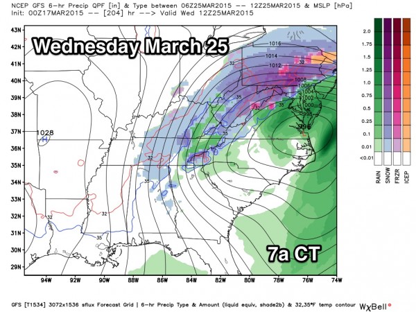
NEXT WEEK: Moisture begins to return Monday, and more light rain could break out. The latest GFS run hints at some risk of thunderstorms Tuesday, followed by sharply colder air Wednesday. In fact, the 00Z GFS even suggests a chance of snow flurries over North Alabama Wednesday morning. This will probably change, but the idea is certainly credible. Blog readers know it is way too early to be planting anything that could be harmed by freezing temperatures.
AT THE BEACH: About 7 to 9 hours of sunshine today from Panama City to Gulf Shores; highs will be close to 70 degrees (cooler down there due to the cool Gulf of Mexico water temperatures). Tomorrow will be generally dry, but mostly cloudy. Then, Thursday through the weekend, days will be mostly cloudy with only a limited amount of sunshine each day, and there will be some risk of rain showers on a daily basis. Nothing too heavy or widespread, however. Highs will remain around 70, and the sea water temperature early this morning at the Dauphin Island Sea Lab is a cool 65 degrees.
FIRST ALERT STORM TEAM TOUR: Our annual severe weather awareness tour across Alabama rolls along; we will be at Burton Campers in Calera this evening. Just drop by anytime from 4:00 until 6:30… you can watch me do weather live on ABC 33/40, get some free stuff to take home, and have a chance to win several NOAA Weather Radios we will be giving away. If you need your weather radio programmed or checked, bring it by and we will be glad to help.
WEATHER BRAINS: Don’t forget you can listen to our weekly 90 minute netcast anytime on the web, or on iTunes. This is the show all about weather featuring many familiar voices, including our meteorologists here at ABC 33/40. Great to have author Kim Cross on the show this week; scroll down for show notes.
CONNECT: You can find me on all of the major social networks…
Facebook
Twitter
Google Plus
Instagram
I will be speaking today at the Sylacauga Rotary Club… look for the next Weather Xtreme video here by 4:00 this afternoon. Enjoy the day!
Category: Alabama's Weather


