

Clouds Hang Around; Colder Late This Week
An all new edition of the ABC 33/40 Weather Xtreme video is available in the player on the right sidebar of the blog. You can subscribe to the Weather Xtreme video on iTunes by clicking here.
AT DAYBREAK: Alabama is covered by low clouds, some fog, and drizzle early this morning with temperatures in the 50s. Most of the significant rain is now east of the state, and while most of the day today will be dry, clouds will hang tough. We could see a few peeks of sunshine late this afternoon… and the high today will be in the 60s.
TOMORROW/WEDNESDAY: These two days are looking dry and mild with a mix of sun and clouds; low to mid 70s are likely tomorrow, and the GFS and the NAM are both printing a high of 77 for Birmingham Wednesday. We do note on these two days a few severe thunderstorms could break out across parts of the nation’s mid-section, but we do not expect severe weather issues in our state when that systems arrives later.
THURSDAY/FRIDAY: Clouds increase Thursday, and showers are possible Thursday afternoon into Thursday night… maybe a thunderstorm… ahead of a cold front. For now it doesn’t look like a big rain event, with amounts expected to be well under 1/2 inch.
A few showers could linger into Friday morning as much colder air rushes into the state; we won’t get past the mid 50s Friday with a very cool north breeze.
RAW SATURDAY: A deep upper trough over the eastern half of the U.S. will set up a cold late March weekend. Saturday looks pretty raw; mostly cloudy, breezy, and cold with a chance of a little drizzle during the morning hours, maybe even a few early morning snow flurries. Most North Alabama communities won’t get out of the 40s.
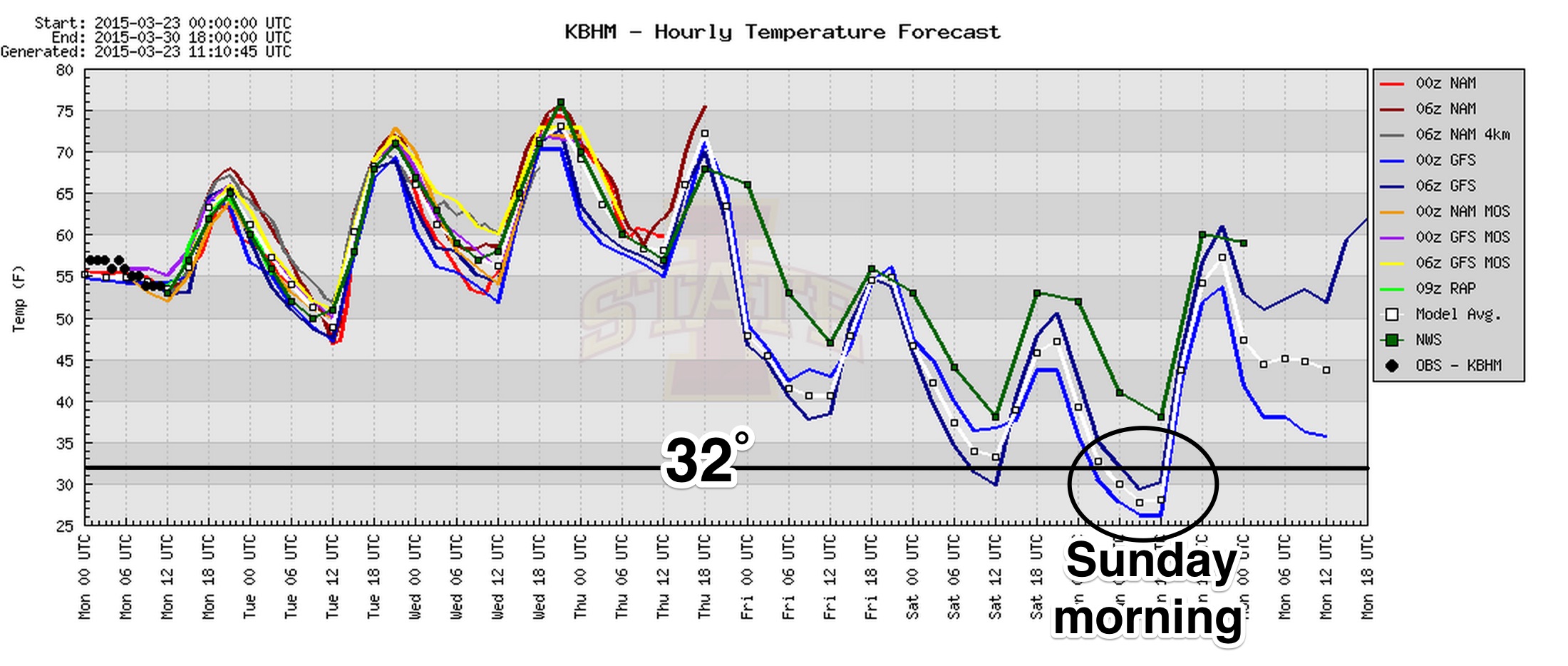
SUNDAY MORNING FREEZE? The sky will clear Saturday night, and the stage is set for a late season freeze early Sunday. The GFS is printing a low of 29 degrees for Birmingham… many places to the north could see low to mid 20s. This is why we have been telling you for weeks it is way too early to plant anything that will be harmed by freezing temperatures. I always recommend tax day, April 15, as a safe time to plant without too much worry about a freeze.
NEXT WEEK: Monday and Tuesday look dry and warmer; then a chance of showers and storms will return by mid-week on Wednesday. See the Weather Xtreme video for maps, graphics, and more details.
WEATHER BRAINS: Don’t forget you can listen to our weekly 90 minute netcast anytime on the web, or on iTunes. This is the show all about weather featuring many familiar voices, including our meteorologists here at ABC 33/40. We will produce this week’s show tonight at 8:30p CT… you can watch it on “James Spann 24/7” on cable systems around the state, or on the web here.
CONNECT: You can find me on all of the major social networks…
Facebook
Twitter
Google Plus
Instagram
I have weather programs today at Meadow View Elementary in Alabaster… and West Elementary in Vestavia Hills. Look for the next Weather Xtreme video here by 4:00 this afternoon. Enjoy the day!
Category: Alabama's Weather
About the Author (Author Profile)
James Spann is one of the most recognized and trusted television meteorologists in the industry. He holds the AMS CCM designation and television seals from the AMS and NWA. He is a past winner of the Broadcast Meteorologist of the Year from both professional organizations.Subscribe
If you enjoyed this article, subscribe to receive more just like it.


