

Dry and Mild Today; Much Colder Friday
An all new edition of the ABC 33/40 Weather Xtreme video is available in the player on the right sidebar of the blog. You can subscribe to the Weather Xtreme video on iTunes by clicking here.
MILD AFTERNOONS: We are starting this day in the 40s, but look for a high up in the mid 70s this afternoon with a mix of sun and clouds. Tomorrow will be a bit warmer with a high between 77 and 80 degrees; moisture levels will rise a bit and we will probably need to mention the risk of a few isolated showers, but a majority of the day will be dry.
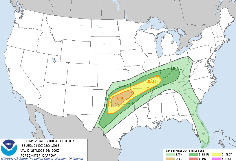
TO THE WEST: Severe storms are possible today and tomorrow northwest of Alabama; there is an “enhanced” risk of severe storms tomorrow just southeast of Oklahoma City; this is one of the new severe weather risk categories that is between “slight” and “moderate”.
COLDER AIR ARRIVES LATER THIS WEEK: Clouds increase Thursday, and a few showers are possible late Thursday afternoon and Thursday night as the cold front passes through our state. No severe weather is expected, and rain amounts should be under 1/2 inch… and maybe even under 1/4 inch. Seems like the main window for showers will come from about 4:00 p.m. Thursday through 4:00 a.m. Friday.
A cool breeze develops Friday; we won’t make it past the mid 50s with a mix of sun and clouds.
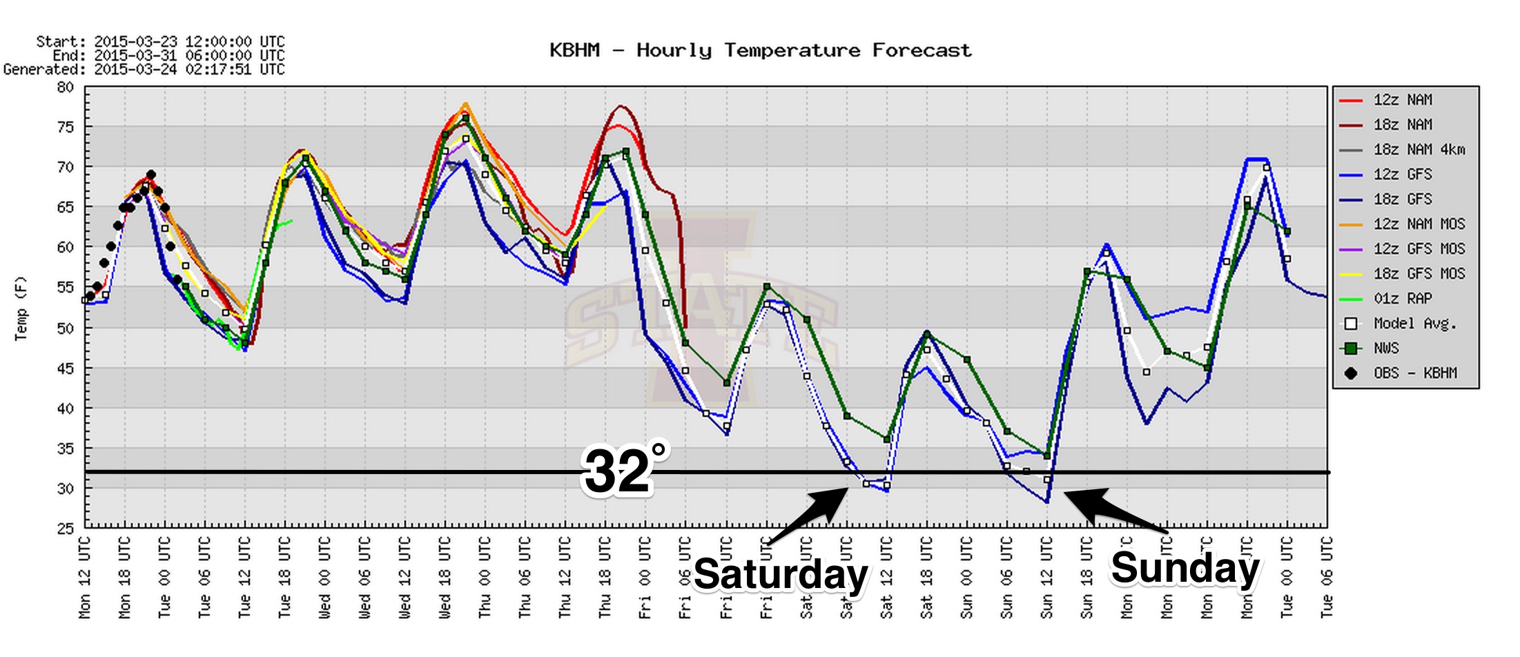
LATE SEASON FREEZE POTENTIAL: The GFS is printing a low of 31 degrees for Birmingham early Saturday morning… the day Saturday looks breezy and cold. As the deep upper trough passes overhead, it will bring cloudy periods, and maybe even a sprinkle or a snow flake during the morning hours. Best chance of snow flurries Saturday morning will come over the northwest corner of the state around Muscle Shoals. Parts of North Alabama will struggle to get out of the 40s.
Another freeze is possible early Sunday with a clear sky and light wind; lows in the 28-34 degree range are likely. Then, a warming trend begins Sunday afternoon with a high in the low to mid 60s along with a good supply of sunshine.
NEXT WEEK: For now Monday and Tuesday look dry and warmer for North/Central Alabama… but the GFS continues to advertise a robust mid-week system that could bring potential for heavy rain and strong storms by Wednesday or Thursday. See the Weather Xtreme video for maps, graphics, and more details.
WEATHER BRAINS: Don’t forget you can listen to our weekly 90 minute netcast anytime on the web, or on iTunes. This is the show all about weather featuring many familiar voices, including our meteorologists here at ABC 33/40. Scroll down for the show notes on the new episode we recorded last night.
CONNECT: You can find me on all of the major social networks…
Facebook
Twitter
Google Plus
Instagram
I have a weather program this morning at Concord Elementary School in Jefferson County… look for the next Weather Xtreme video here by 4:00 this afternoon. Enjoy the day!
Category: Alabama's Weather
About the Author (Author Profile)
James Spann is one of the most recognized and trusted television meteorologists in the industry. He holds the AMS CCM designation and television seals from the AMS and NWA. He is a past winner of the Broadcast Meteorologist of the Year from both professional organizations.Subscribe
If you enjoyed this article, subscribe to receive more just like it.


