

Cold Front Arrives Tomorrow Night
**No afternoon Weather Xtreme video today… I am in Bowling Green, KY; will speak this evening at Western Kentucky University**
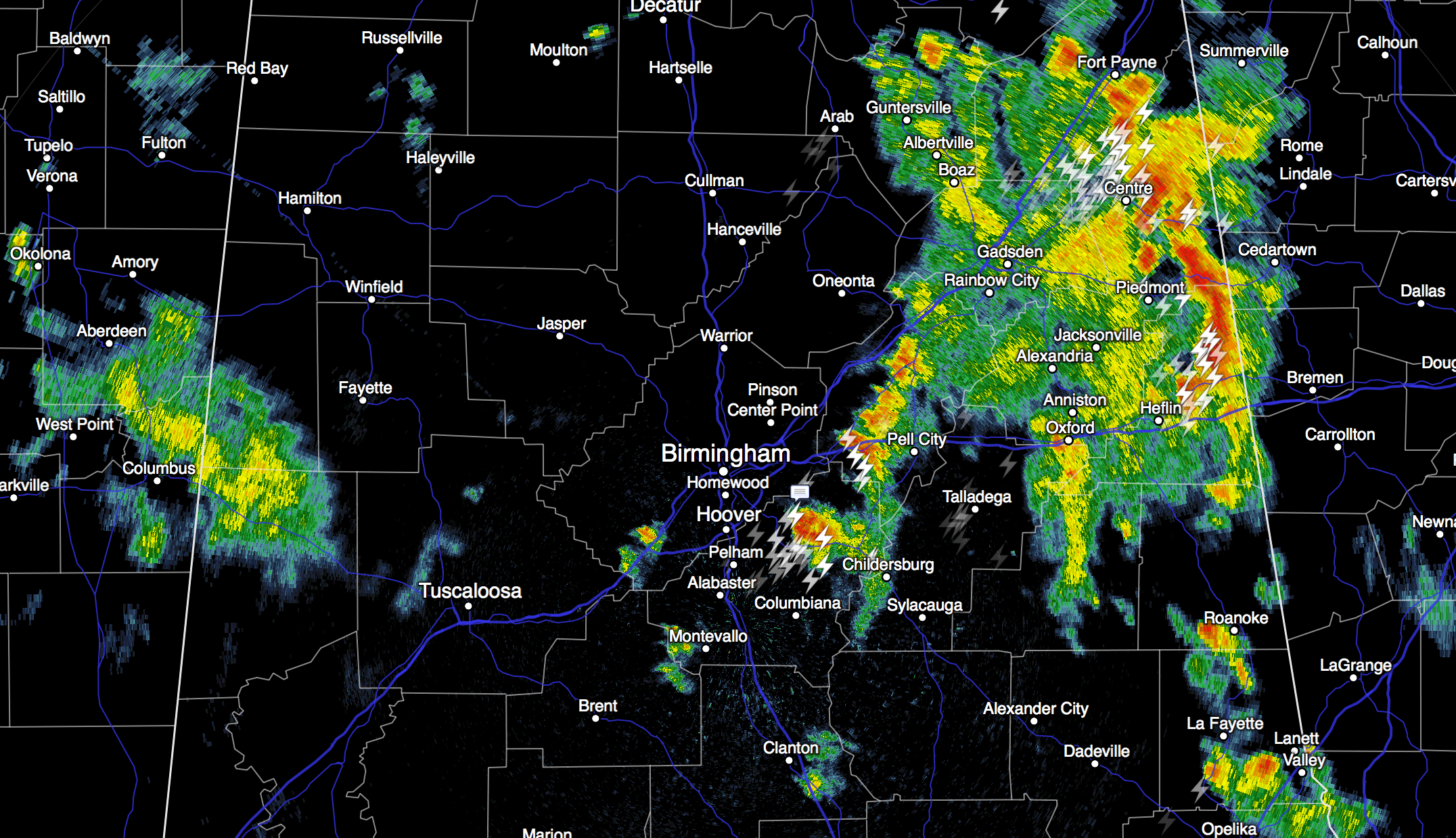
SCATTERED STORMS: Heavier storms this afternoon as of 3:30 are near the Georgia border, and over Shelby and St. Clair Counties. They are producing lots of lighting, and some small hail as they move northeast…
The storms will die down tonight, but a few showers could linger into the late night hours.
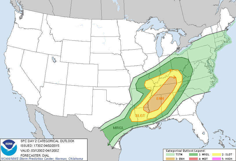
TOMORROW: SPC maintains an “enhanced” severe weather risk over Northwest Alabama, and the standard “slight” risk is up for the northern and central counties…
The high resolution NAM model shows very little development during the day tomorrow; the sun will be out at times and the high will be close to 80. A few isolated storms could fire up over Northwest Alabama by late afternoon… those are the ones that might produce an isolated tornado, where the enhanced severe weather risk is in place.
But it looks like a mostly linear thunderstorm event… the NAM suggests the line of storms will be approaching Birmingham/Tuscaloosa/Anniston/Gadsden by 10:00 p.m… (model output below is valid at 10p CDT tomorrow)
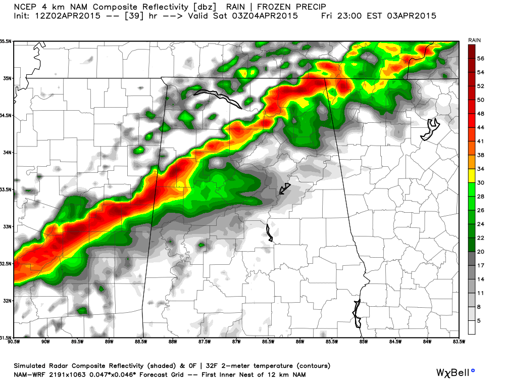
The main threat will come from hail and strong straight line winds, and the storms should weaken after midnight as they move south of I-20. Rain amounts of around 1/2 inch are likely.
EASTER WEEKEND: A cool, dry airmass moves in… Saturday will be sunny with a high in the mid 60s… and Sunday’s high will be close to 70 with a bright sunny sky. Important to note Sunday morning will be pretty chilly… most places will see a low in the low 40s, but colder valleys and protected areas will see temperatures in the mid to upper 30s with a chance of scattered light frost. Looks like the last frost threat of the season.
NEXT WEEK: Moist air returns quickly, and showers and storms are possible by Monday. The rest of the week looks warm and rather unsettled with some risk of showers and thunderstorms on just about a daily basis. There could be one or two days with some severe weather threat.
GULF COAST WEATHER: Mostly sunny weather continues along the coast from Panama City over to Gulf Shores tomorrow with a high in the 70s. A few widely scattered showers are possible tomorrow night and Saturday morning, but otherwise the weekend looks fine with a good supply of sunshine both days. Saturday will be a bit cooler with a high in the 60s. Next week, about 7-9 hours of sunshine each day with only widely scattered showers.
WEATHER BRAINS: Don’t forget you can listen to our weekly 90 minute netcast anytime on the web, or on iTunes. This is the show all about weather featuring many familiar voices, including our meteorologists here at ABC 33/40.
CONNECT: You can find me on all of the major social networks…
Facebook
Twitter
Google Plus
Instagram
Look for the next Weather Xtreme video here by 7:00 a.m. tomorrow..
Category: Alabama's Weather
About the Author (Author Profile)
James Spann is one of the most recognized and trusted television meteorologists in the industry. He holds the AMS CCM designation and television seals from the AMS and NWA. He is a past winner of the Broadcast Meteorologist of the Year from both professional organizations.Subscribe
If you enjoyed this article, subscribe to receive more just like it.


