

Severe Storms Possible Tonight
An all new edition of the ABC 33/40 Weather Xtreme video is available in the player on the right sidebar of the blog. You can subscribe to the Weather Xtreme video on iTunes by clicking here.
RADAR CHECK: Thunderstorms are beginning to form over Northwest Alabama this afternoon…
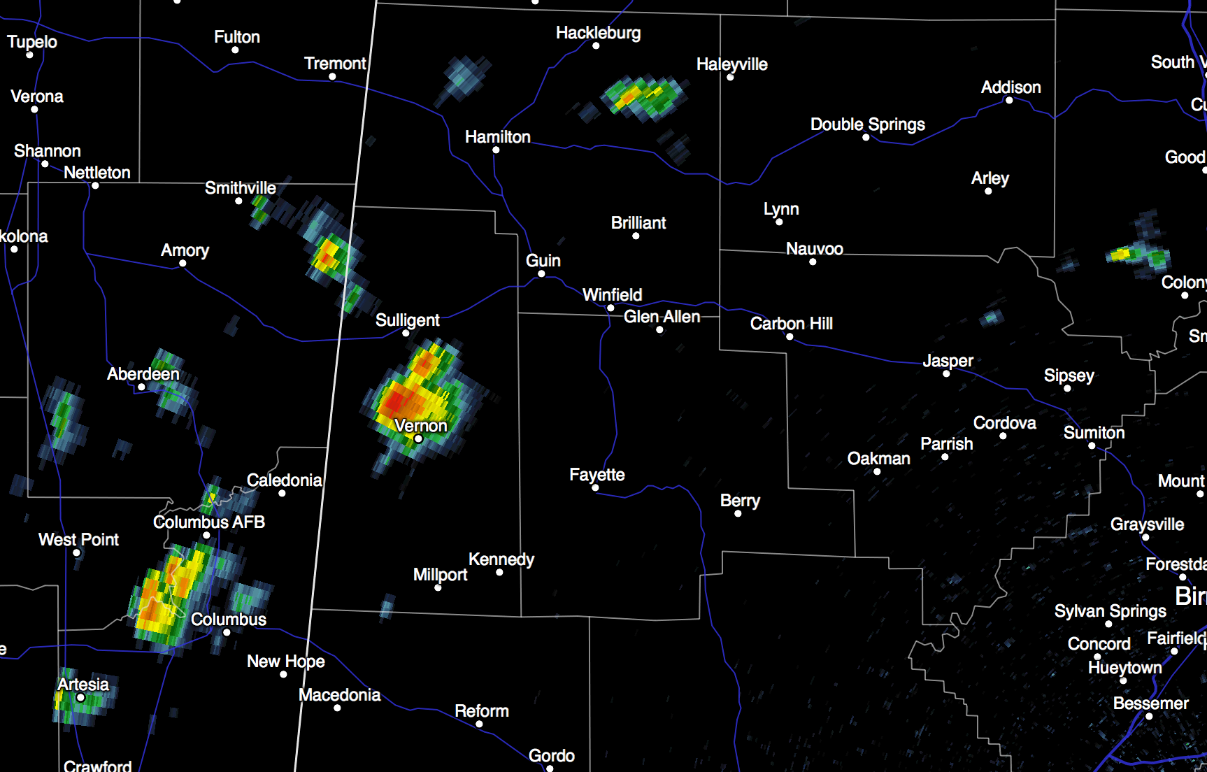
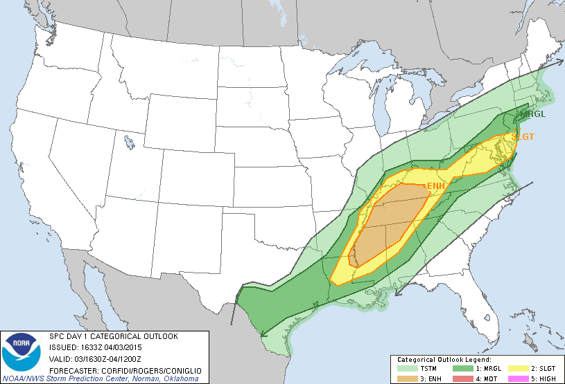
Showers and storms will increase in coming hours as a cold front approaches from the north. Not much change in the overall thinking; SPC maintains an “enhanced” severe weather risk over Northwest Alabama, with a “slight” risk down to Birmingham, and a “marginal” risk to Montgomery.
The higher tornado probabilities are north of Alabama, where a tornado watch is up for parts of Tennessee, Kentucky, and southern Indiana until 9p CT. We can’t rule out an isolated tornado over Northwest Alabama this evening, but the core threats will come from hail and strong straight line winds. High resolution model data hints the most active storms will impact Birmingham, Tuscaloosa, Anniston, and Gadsden between 8:00 p.m. and 12:00 midnight. Storms will weaken after midnight as they move south of I-20.
Of course, when it comes to thunderstorms, expect the unexpected, so we will watch radar trends closely.
EASTER WEEKEND: Tons of sun for Alabama tomorrow and Sunday. It will be cooler tomorrow with a high in the mid 60s, and temperatures will drop to near 40 degrees early Sunday. Colder valleys and protected areas will reach the 30s with a chance of scattered light frost. A good chance this will be the last frost threat of the season. Sunday’s high will be somewhere between 67 and 70 degrees.
NEXT WEEK: Moisture returns quickly, and Monday looks wet with a good chance of showers and thunderstorms. Then, moist air stays in place for the rest of the week; looks like highs in the low 80s Tuesday through Thursday. There will be a risk of scattered showers and storms each day, but also there will be some very nice intervals of sunshine along the way. Showers and storms should increase by Friday and Saturday (April 10-11) with an upper trough approaching. See the Weather Xtreme video for maps, graphics, and more details.
GULF COAST WEATHER: Just a few scattered showers on the coast tonight and tomorrow morning from Panama City over to Gulf Shores, otherwise mostly sunny days and fair nights will continue through Monday. Widely scattered showers are possible Tuesday through Thursday of next week, but on the positive side expect about 6 to 8 hours of sunshine each day. Highs will remain in the 70s, and sea water temperatures are in the mid to upper 60s.
WEATHER BRAINS: Don’t forget you can listen to our weekly 90 minute netcast anytime on the web, or on iTunes. This is the show all about weather featuring many familiar voices, including our meteorologists here at ABC 33/40.
CONNECT: You can find me on all of the major social networks…
Facebook
Twitter
Google Plus
Instagram
Stay tuned to the blog for updates on the storms as they fire up tonight…
Category: Alabama's Weather
About the Author (Author Profile)
James Spann is one of the most recognized and trusted television meteorologists in the industry. He holds the AMS CCM designation and television seals from the AMS and NWA. He is a past winner of the Broadcast Meteorologist of the Year from both professional organizations.Subscribe
If you enjoyed this article, subscribe to receive more just like it.


