Drier/Warmer Tomorrow Through Thursday
An all new edition of the ABC 33/40 Weather Xtreme video is available in the player on the right sidebar of the blog. You can subscribe to the Weather Xtreme video on iTunes by clicking here.
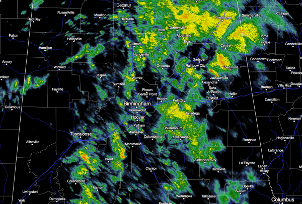
RAINY DAYS AND MONDAYS: As expected, this has been a wet day across the great state of Alabama; rain continues over much of the state at mid-afternoon.
Showers/storms will begin to fade away this evening as short wave energy moves on to the east.
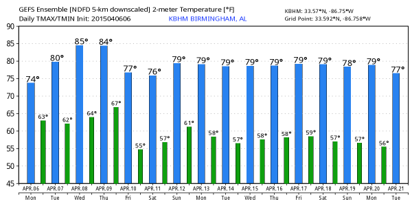
MID-WEEK: Expect some of the warmest weather so far this year in coming days with afternoon highs in the 81 to 85 degree range. Birmingham’s warmest temperature so far in 2015 is 85, set back on April 3. An upper ridge will build across the Deep South, proving the warm temperatures, and keeping showers and storms widely spaced. Any showers should come during the afternoon and evening hours, and the chance of any one spot getting wet tomorrow, Wednesday, and Thursday is only in the 10-20 percent range.
Northwest of Alabama, severe thunderstorms will likely develop in the broad area from Chicago to Dallas/Fort Worth Wednesday and Thursday; a few tornadoes are possible that region as well. But, all of this will remain northwest of Alabama and no severe weather is expected here on these two days.
FRIDAY: A deep surface low moves up into eastern Canada, well north of our state, but it will drag a cold front through with a good chance of showers and thunderstorms. We don’t expect any severe weather in Alabama Friday with limited instability, very little bulk shear, and lapse rates that are not particularly steep. The high Friday will drop back into the 70s due to clouds and showers.
THE ALABAMA WEEKEND: Getting a little model madness making for a lower confidence forecast. The 12z runs of the GFS and the ECMWF (Euro) stall the front over Central Alabama Saturday, and showers will remain possible along and south of that front. For now we will keep a dry forecast from Birmingham north Saturday, but some rain is very possible, if not likely over the southern counties of the state.
Then, on Sunday, the front lifts northward as a warm front, and we will mention a chance of rain statewide, along with possible thunderstorms. Sunday’s high will remain in the 70s.
NEXT WEEK: The weather looks fairly unsettled with broad low pressure at the surface, and an upper trough remaining west of the state… see the Weather Xtreme video for maps, graphics, and more details.
WEATHER BRAINS: Don’t forget you can listen to our weekly 90 minute netcast anytime on the web, or on iTunes. This is the show all about weather featuring many familiar voices, including our meteorologists here at ABC 33/40. We will produce this week’s episode tonight at 8:30 CT… you can watch it on “James Spann 24/7” on cable systems around the state, or on the web here.
CONNECT: You can find me on all of the major social networks…
Facebook
Twitter
Google Plus
Instagram
I had a great time today visiting with the kindergarten students at Gardendale’s First Baptist Church… be looking for them on the Pepsi KIDCAM today at 5:00 on ABC 33/40 News! The next Weather Xtreme video will be posted here by 7:00 a.m. tomorrow…
Category: Alabama's Weather


Comments (6)
Trackback URL | Comments RSS Feed
Sites That Link to this Post