

Warmer, Drier Days Ahead
An all new edition of the ABC 33/40 Weather Xtreme video is available in the player on the right sidebar of the blog. You can subscribe to the Weather Xtreme video on iTunes by clicking here.
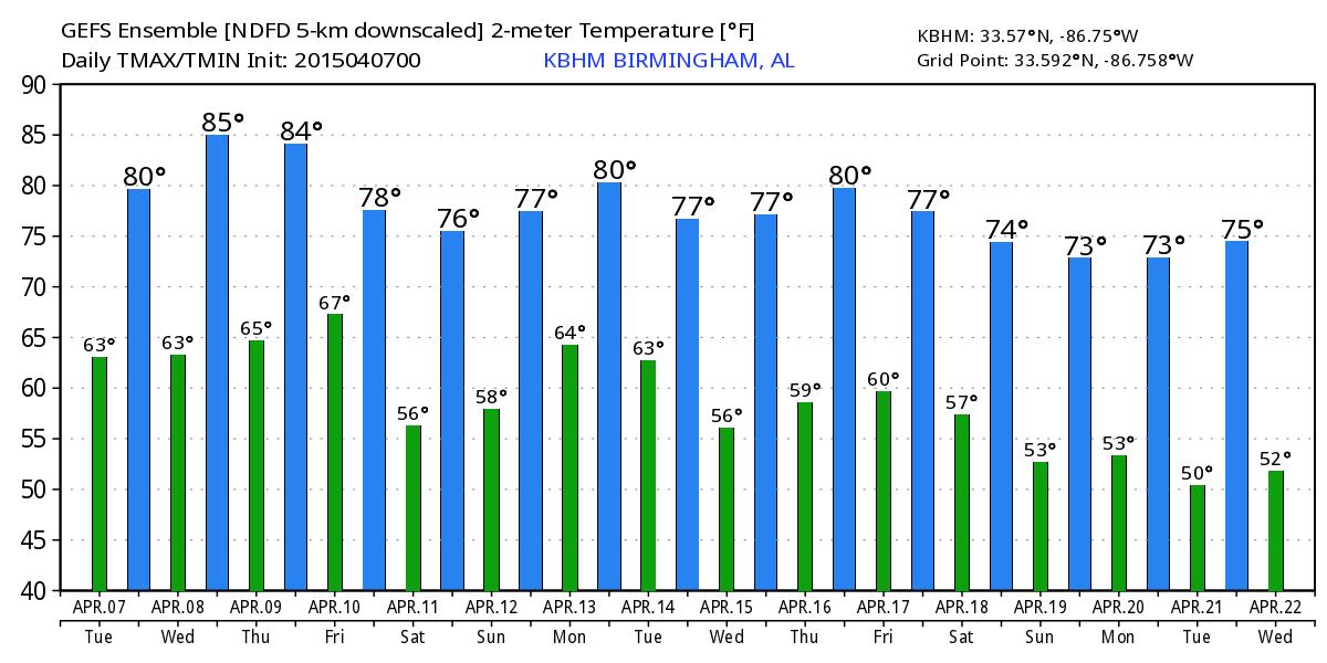
WARM APRIL WEATHER AHEAD: Temperatures were below average across Alabama yesterday (the average high for April 7 in Birmingham is 72) thanks to the clouds and rain, but we will see above average highs today and through mid-week as an upper ridge builds across the region. Low 80s are likely today, with mid 80s possible tomorrow and Thursday.
The warm air aloft associated with the ridge will also keep a lid on any potential showers. The chance of rain is certainly not zero today through Thursday, but any showers and storms will be very isolated, and mostly during the afternoon and evening hours. The chance any one spot getting a shower through Thursday is only about 15 percent.
NORTHWEST OF ALABAMA: Severe storms are likely across parts of the nation’s heartland tomorrow and Thursday… in fact there is an “enhanced” severe weather risk Thursday from near Chicago to St. Louis. A few tornadoes are possible in this region as well, but all of this really active weather remains northwest or our state.
FRIDAY FRONT: A cold front will bring a band of showers and thunderstorms to Alabama Friday, but no severe weather is expected with low instability values, very little bulk shear, and weak wind fields. The high on Friday will drop back in the 70s because of clouds and rain.
ALABAMA’S WEEKEND: The front will stall out somewhere across Central Alabama Saturday, and where the boundary stops will determine who gets rain, and who stays dry. For now we will project the front to stall just south of I-20, so from Birmingham north most of the day Saturday should be rain-free, but the southern half of the state will be wet at times. Saturday’s high will be in the 70s.
Then, on Sunday, the surface boundary will lift northward as a warm front, and we will mention a chance of showers statewide. The high Sunday will be in the upper 70s.
NEXT WEEK: Another cold front will bring showers and storms Monday, but once again the main dynamic forcing will be north of the state, meaning the severe weather threat for now looks low. Then, cooler and drier air should work into the state Tuesday and Wednesday. See the Weather Xtreme video for maps, graphics, and more details.
WEATHER BRAINS: Don’t forget you can listen to our weekly 90 minute netcast anytime on the web, or on iTunes. This is the show all about weather featuring many familiar voices, including our meteorologists here at ABC 33/40. Scroll down for the show notes on the new episode we recorded last night.
CONNECT: You can find me on all of the major social networks…
Facebook
Twitter
Google Plus
Instagram
I have a weather program this morning at Alberta Elementary School in Tuscaloosa… they are in their new building which looks fantastic; the old building was destroyed by the EF-4 tornado April 27, 2011. Look for the next Weather Xtreme video here by 4:00 this afternoon. Enjoy the day!
Category: Alabama's Weather
About the Author (Author Profile)
James Spann is one of the most recognized and trusted television meteorologists in the industry. He holds the AMS CCM designation and television seals from the AMS and NWA. He is a past winner of the Broadcast Meteorologist of the Year from both professional organizations.Subscribe
If you enjoyed this article, subscribe to receive more just like it.


