

Cold Front Arrives Friday Morning
An all new edition of the ABC 33/40 Weather Xtreme video is available in the player on the right sidebar of the blog. You can subscribe to the Weather Xtreme video on iTunes by clicking here.
WARM APRIL AFTERNOON: As expected, it is a very warm April day across the great state of Alabama with most communities up in the low to mid 80s. Interesting to note Tuscaloosa is cooler with temperatures only in the mid 70s; a small but persistent patch of clouds has lingered right over the Druid City through the day. No rain on radar, and the chance of showers will remain very low overnight.
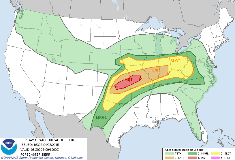
NORTH AND WEST OF HERE: A “moderate” severe weather risk is up for parts of Oklahoma, Kansas, and Missouri, and severe storms with tornadoes will remain possible in that region.
TOMORROW/FRIDAY: Our weather won’t change much tomorrow… mostly dry and warm with only isolated afternoon showers or storms. The surface low, partly responsible for the severe weather across the nation’s mid-section, will lift north toward Canada tomorrow night and Friday, and will drag a cold front into Alabama.
Showers and storms ahead of the front will enter far North Alabama after midnight tomorrow night, and they could pack a punch initially over the Tennessee Valley. SPC has pulled the “slight risk” of severe weather down into extreme North Alabama due to this potential; places like Muscle Shoals and Athens could see storms with some hail and strong, gusty straight line winds between 2:00 and 6:00 a.m. Friday.
Then, during the day Friday, the storms will weaken as they move southward, and severe weather is not expected for places like Birmingham, Tuscaloosa, Anniston, and Gadsden. The best chance of showers and storms will come during the morning hours, with drier air moving in by Friday afternoon. Friday’s high will drop back into the 70s due to the clouds and rain.
THE ALABAMA WEEKEND: It looks delightful for the northern two-thirds of the state, with sunny pleasant days and clear cool nights. The high Saturday will be in the mid 70s, and then close to 80 degrees Sunday afternoon. Morning lows will be well down in the 50s, with 40s for the colder valleys. Any showers will be confined to far South Alabama, and even there rain won’t be too widespread or heavy.
NEXT WEEK: Moisture begins to return, and we will deal with some risk of showers Monday and Tuesday, but the best dynamic support for severe weather will remain north and west of Alabama. See the Weather Xtreme video for maps, graphics, and more details.
WEATHER BRAINS: Don’t forget you can listen to our weekly 90 minute netcast anytime on the web, or on iTunes. This is the show all about weather featuring many familiar voices, including our meteorologists here at ABC 33/40.
CONNECT: You can find me on all of the major social networks…
Facebook
Twitter
Google Plus
Instagram
I had a great time today visiting with the second graders at East Elementary in Cullman… be looking for them on the Pepsi KIDCAM today at 5:00 on ABC 33/40 News! The next Weather Xtreme video will be posted by 7:00 a.m. tomorrow…
Category: Alabama's Weather
About the Author (Author Profile)
James Spann is one of the most recognized and trusted television meteorologists in the industry. He holds the AMS CCM designation and television seals from the AMS and NWA. He is a past winner of the Broadcast Meteorologist of the Year from both professional organizations.Subscribe
If you enjoyed this article, subscribe to receive more just like it.


