

Cold Front Arrives Tomorrow
An all new edition of the ABC 33/40 Weather Xtreme video is available in the player on the right sidebar of the blog. You can subscribe to the Weather Xtreme video on iTunes by clicking here.
ANOTHER WARM DAY AHEAD: Yesterday gave Alabama quite the summer preview… some highs included 89 at Dothan, 88 at Troy, and 87 at Anniston and Montgomery. We project a high today in the low to mid 80s for most North/Central Alabama communities with a mix of sun and clouds; the chance of an afternoon shower for any one given spot remains small.
NORTHWEST OF ALABAMA: There is a large “enhanced” risk of severe weather from near Shreveport to Chicago…
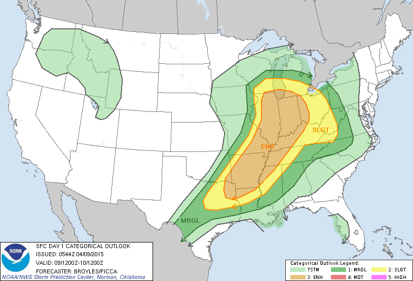
These storms will move into the northwest corner of Alabama after midnight; SPC has that little part of Alabama (around Muscle Shoals) in the standard “slight risk” of severe storms for the potential of strong gusty winds and some hail. However, the storms should weaken as they move deeper into Alabama toward daybreak tomorrow.
FRIDAY FRONT: Models have trended a little slower with the movement of the surface front tomorrow. The day will be cloudy with a good chance of showers and a few thunderstorms; SPC has the southern third of the state in the standard “slight” risk of severe weather tomorrow afternoon as there will be a decent amount of instability. But, overall wind fields are weak and the threat looks fairly limited.
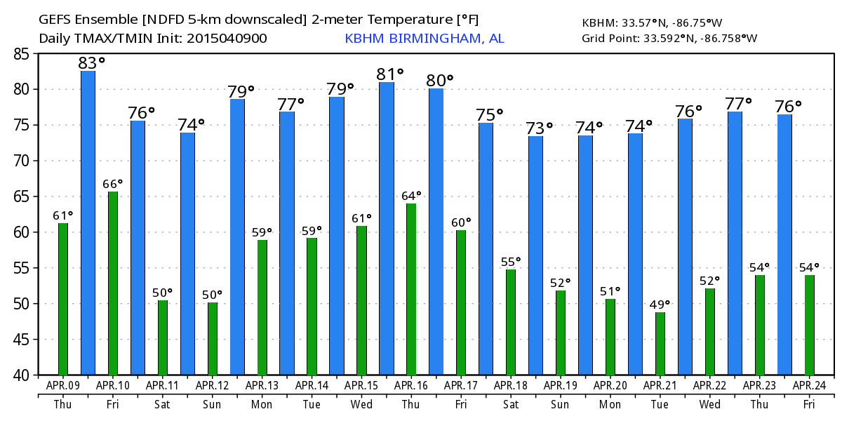
In terms of timing, with the slower movement of the front I think we need to maintain at least a chance of showers into the afternoon hours for North/Central Alabama (places like Birmingham, Tuscaloosa, Anniston, and Gadsden). Showers will end during the evening as drier air drops in from the north. Tomorrow’s high will be in the mid to upper 70s.
THE WEEKEND: Saturday looks like a delightful day for the northern two-thirds of the state with ample sunshine and a high in the low to mid 70s. Humidity values will also be considerably lower. The dry air should hold in place Sunday for the northern counties, but showers will be possible from about Montgomery south Sunday afternoon.
NEXT WEEK: Scattered showers and storms are possible statewide Monday as a southerly flow becomes established again, and it looks like there will be some risk of rain every day next week as the moist air stays in place. For now we don’t see any overwhelming evidence of severe weather problems in Alabama, but we always have to watch trends closely this time of the year. Highs next week will be generally in the 75-80 degree range, not far from average values for mid-April in Alabama. See the Weather Xtreme video for maps, graphics, and more details.
WEATHER BRAINS: Don’t forget you can listen to our weekly 90 minute netcast anytime on the web, or on iTunes. This is the show all about weather featuring many familiar voices, including our meteorologists here at ABC 33/40.
CONNECT: You can find me on all of the major social networks…
Facebook
Twitter
Google Plus
Instagram
Look for the next Weather Xtreme video here by 4:00 this afternoon…. enjoy the day…
Category: Alabama's Weather
About the Author (Author Profile)
James Spann is one of the most recognized and trusted television meteorologists in the industry. He holds the AMS CCM designation and television seals from the AMS and NWA. He is a past winner of the Broadcast Meteorologist of the Year from both professional organizations.Subscribe
If you enjoyed this article, subscribe to receive more just like it.


