

Showers/Storms Arrive Tomorrow
An all new edition of the ABC 33/40 Weather Xtreme video is available in the player on the right sidebar of the blog. You can subscribe to the Weather Xtreme video on iTunes by clicking here.
WARM APRIL AFTERNOON: Temperatures are generally in the 80-84 degree range across the great state of Alabama this afternoon with a mix of sun and clouds; nothing showing up on radar. The weather is getting active north and west of the state; a tornado watch is up for parts of Texas, Arkansas, Louisiana… and to the north another one is in effect for much of Illinois and some of the adjacent states, including Chicago.
A large “enhanced” severe weather risk continues from the southern Great Lakes down to the Ark-La-Tex region through tonight…
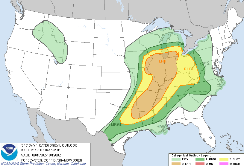
Note the “slight” risk extends down into far Northwest Alabama… and keep in mind this outlook runs through 7:00 a.m. tomorrow.
SHOWERS AND STORMS INTO ALABAMA: A line of strong, possibly severe storms will enter the northwest corner of the state between 1:00 and 3:00 a.m… and they could produce hail and strong winds as they move through places like Florence and Muscle Shoals.
But, the storms should weaken as they drop south toward daybreak, and it continue to look like the chance of severe weather is low for places like Birmingham, Tuscaloosa, Anniston, and Gadsden.
But, SPC has a “slight” severe weather risk up tomorrow afternoon for the southern counties of the state… instability values will be higher there, and some of the storms from U.S. 80 south (Demopolis to Selma to Montgomery to Opelika) could produce hail and gusty winds. The tornado threat is very low for South Alabama tomorrow afternoon despite the SPC risk due to weak wind fields and low bulk shear values.
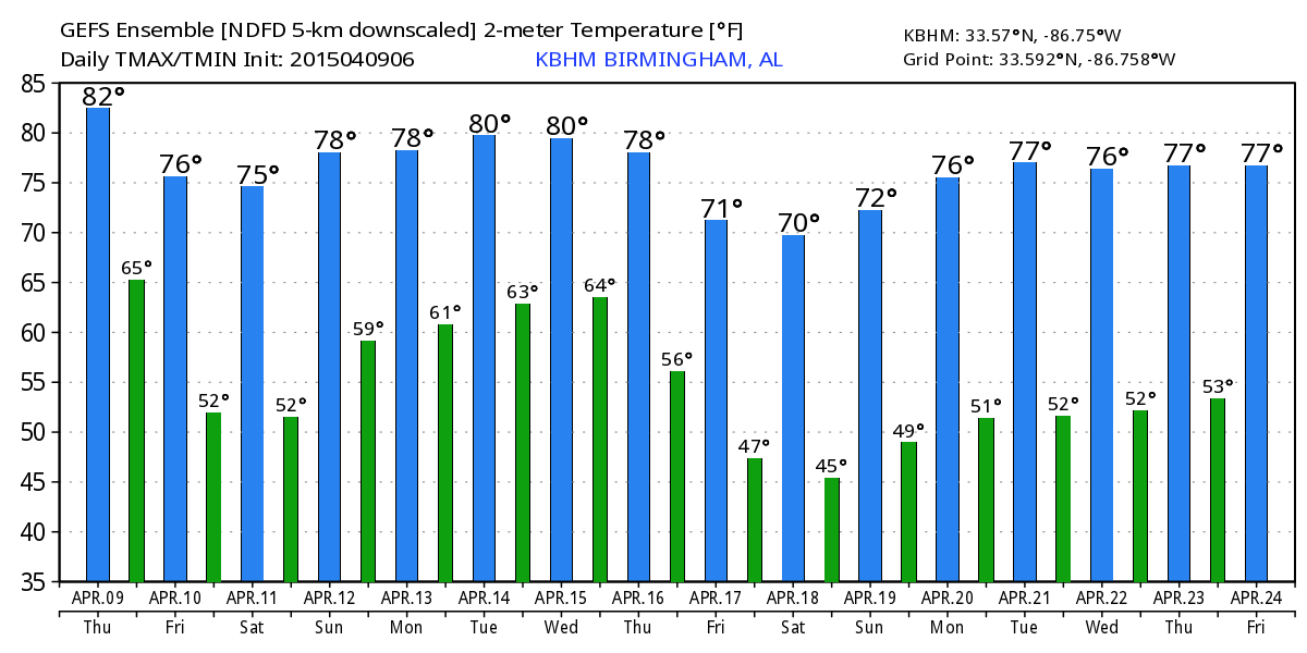
THE ALABAMA WEEKEND: Still looking very nice for most of the state; for North/Central Alabama Saturday will feature a sun-filled sky with lower humidity and a high in the mid 70s. And, we stay dry Sunday with a partly to mostly sunny sky along with a high in the upper 70s. Any showers over the weekend will be confined to far South Alabama, and even there those showers will be widely spaced.
NEXT WEEK: Moisture comes back, and it looks like we will have some risk of showers and thunderstorms on daily basis through the week; a deep upper trough could bring the risk of strong to severe storms around Thursday (April 16)… but too early to be specific on that risk. See the Weather Xtreme video for maps, graphics, and more details.
AT THE BEACH: Expect about 2 to 4 hours of sunshine on the Gulf Coast from Panama City west to Gulf Shores tomorrow and Saturday with a few passing showers and thunderstorms likely. Then, 5 to 7 hours of sunshine Sunday into early next week with scattered showers and storms possible. Highs on the immediate coast will be mostly in the 70s, and the sea water temperature this afternoon at the Dauphin Island Sea Lab is 71 degrees.
WEATHER BRAINS: Don’t forget you can listen to our weekly 90 minute netcast anytime on the web, or on iTunes. This is the show all about weather featuring many familiar voices, including our meteorologists here at ABC 33/40.
CONNECT: You can find me on all of the major social networks…
Facebook
Twitter
Google Plus
Instagram
Look for the next Weather Xtreme video here by 7:00 a.m. tomorrow…
Category: Alabama's Weather
About the Author (Author Profile)
James Spann is one of the most recognized and trusted television meteorologists in the industry. He holds the AMS CCM designation and television seals from the AMS and NWA. He is a past winner of the Broadcast Meteorologist of the Year from both professional organizations.Subscribe
If you enjoyed this article, subscribe to receive more just like it.


