

Unsettled April Weather Pattern Continues
An all new edition of the ABC 33/40 Weather Xtreme video is available in the player on the right sidebar of the blog. You can subscribe to the Weather Xtreme video on iTunes by clicking here.
RADAR CHECK: Showers are still in progress across much of Alabama this afternoon, with some of the heavier rain and storms lined up from Demopolis to Camden…

Showers and a few storms will continue at times tonight.
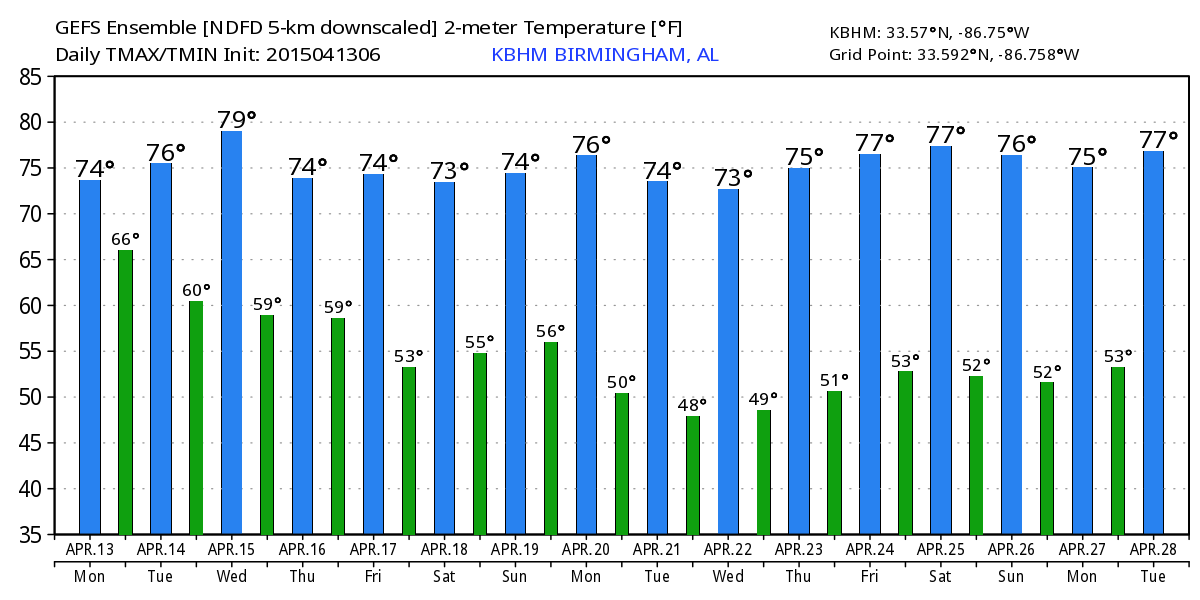
TOMORROW: This just might be the driest day of the week. Still, the sky will be mostly cloudy and there is some risk of rain, but the showers should be widely spaced, and a decent part of the day should be rain-free with a high in the 70s. You might even see a patch of blue sky from time to time as the leave short wave pulls off to the northeast.
WEDNESDAY: High resolution model guidance suggests we will have a few showers and storms around Wednesday, but they will be scattered in nature, and it certainly won’t rain all day. The sky will remain mostly cloudy, and the high will be in the mid 70s.
THURSDAY/FRIDAY: These two days look pretty wet; expect occasional showers and thunderstorms, with potential for the rain to be heavy at times. We should note Thursday should be cooler over the eastern half of Alabama with a cold air damming (CAD) pattern setting up; some communities near the Georgia border might not get past the low to mid 60s.
SATURDAY: More rain. The 12Z GFS shows a deep (999 mb) surface low near Tulsa, OK… and showers and storms are likely again statewide. In fact, this might be a setup for strong, maybe severe thunderstorms, but for now instability values look pretty limited, and the more significant threat could come from flash flooding. Rain amounts of 3 to 5 inches are likely by Saturday evening.
SUNDAY: Finally, some hope for a brighter day as a dry slot of air works into the state. We can’t rule out an afternoon shower or two, but a decent part of the day should be without rain, and the sun could break out at times. Highs will hold in the 70s over the weekend.
NEXT WEEK: An upper trough sets up over the eastern half of the nation, suggesting temperatures for a decent part of the week will be a bit below average around here, with highs around 70, and lows down in the 40s on a few mornings. See the Weather Xtreme video for maps, graphics, and more details.
WEATHER BRAINS: Don’t forget you can listen to our weekly 90 minute netcast anytime on the web, or on iTunes. This is the show all about weather featuring many familiar voices, including our meteorologists here at ABC 33/40. We will produce this week’s show tonight at 8:30 CT… you can watch it on “James Spann 24/7” on cable systems around the state, or on the web here.
CONNECT: You can find me on all of the major social networks…
Facebook
Twitter
Google Plus
Instagram
I had a great time today visiting with kindergarten students at Coldwater Elementary School in Calhoun County, and at Oliver Elementary in Birmingham… be looking for them on the Pepsi KIDCAM today at 5:00 and 6:00 on ABC 33/40 News! The next Weather Xtreme video will be posted here by 7:00 a.m. tomorrow…
Category: Alabama's Weather
About the Author (Author Profile)
James Spann is one of the most recognized and trusted television meteorologists in the industry. He holds the AMS CCM designation and television seals from the AMS and NWA. He is a past winner of the Broadcast Meteorologist of the Year from both professional organizations.Subscribe
If you enjoyed this article, subscribe to receive more just like it.


