

Showers A No-Show So Far Today
An all new edition of the ABC 33/40 Weather Xtreme video is available in the player on the right sidebar of the blog. You can subscribe to the Weather Xtreme video on iTunes by clicking here.
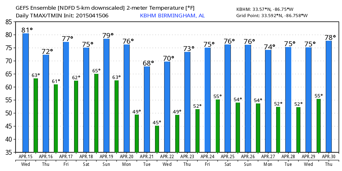
RADAR CHECK: For a change we have nothing showing on radar as of 3:00 this afternoon; seems like nobody is complaining about the lack of showers so far. We have seen patches of blue sky, and temperatures have warmed into the mid to upper 70s in most places. Dry air in the mid levels is preventing shower formation, but we will need to maintain at least the chance of widely scattered showers and storms through tonight.
TOMORROW/FRIDAY: Cooler air slips into the eastern half of the state tomorrow thanks to the CAD (cold air damming) effect… places like Cedar Bluff, Heflin, and Wedowee could see a high only in the low 60s, while communities to the west around the Mississippi border might be close to 80 degrees. The sky will remain mostly cloudy, and a few passing showers are likely, but it won’t rain all day.
We will mention scattered showers or storms Friday, but a decent part of the day could very well be dry, much like today, with the better dynamic forcing west of the state. The high Friday will be in the 70s with only a limited amount of sun.
OUR WEEKEND: Saturday looks wet, as a signifiant upper trough lifts out of the Rockies, and moist air stays in place. We will forecast periods of rain, and possibly a thunderstorm with a high in the 75-78 degree range. It won’t rain all day Saturday, but there is a good chance it will rain several times during the day.
We will need to maintain the chance of showers and thunderstorms Sunday as the trough axis moves over the state; we could see a few strong storms Sunday afternoon with potential for small hail due to the colder air aloft, but for now a really significant severe weather threat doesn’t seem likely. The high Sunday afternoon will be in the upper 70s for most.
NEXT WEEK: Just an outside risk of a stray shower or two Monday, especially over East Alabama, and we finally get into some nice, dry, continental air Tuesday and Wednesday with a good supply of sunshine both days. Early morning temperatures should reach the 40s early Tuesday and Wednesday morning. See the Weather Xtreme video for maps, graphics, and more details.
WEATHER BRAINS: Don’t forget you can listen to our weekly 90 minute netcast anytime on the web, or on iTunes. This is the show all about weather featuring many familiar voices, including our meteorologists here at ABC 33/40.
CONNECT: You can find me on all of the major social networks…
Facebook
Twitter
Google Plus
Instagram
I had a great time today visiting the kindergarten kids at Hueytown Elementary… be looking for them on the Pepsi KIDCAM today at 5:00 on ABC 33/40 News! The next Weather Xtreme video will be posted here by 7:00 a.m. tomorrow…
Category: Alabama's Weather
About the Author (Author Profile)
James Spann is one of the most recognized and trusted television meteorologists in the industry. He holds the AMS CCM designation and television seals from the AMS and NWA. He is a past winner of the Broadcast Meteorologist of the Year from both professional organizations.Subscribe
If you enjoyed this article, subscribe to receive more just like it.


