

Storms Already Developing in Eastern Mississippi
By Bill Murray, Saturday 120 pm
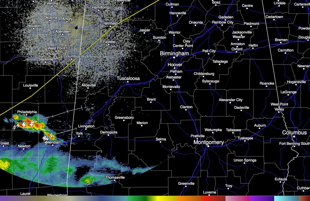
A strong thunderstorm has developed over eastern Mississippi between Philadelphia and Meridian. It is moving northeast and will impact Sumter and southern Pickens Counties starting between 1:30 and 2 p.m. They are not severe for now but are in an environment of moderate instability with decent wind shear so they will persist into Alabama. They are being triggered by an upper level disturbance that is crossing the Mississippi River out of Louisiana. There is also some enhancement from an upper level jet streak just to the west.
South of US-82, CAPE values are already at 1,000 j/kg or greater. They will continue to increase through the afternoon as sun works on a moist atmosphere to create more instability. The storms back to the southwest of this leading activity will cut off moisture inflow from the Gulf, so the storms may have to work with what they have available. But dewpoints are already in the upper 60s so that may not be much of a problem.
There will be scattered storms to severe storms over Central Alabama this afternoon. The SPC slight risk severe weather outlook boundary is shown in yellow on the graphic. Areas south of that have the best chances for severe storms to develop this afternoon and evening. I don’t expect there will be much severe activity to the north of areas within 25-50 miles of I-20. Damaging winds and hail look likely. There is a small chance of a tornado, but with southwesterly surface winds, the chance is minimized.
Stay tuned for the latest severe weather information throughout the afternoon and evening.
Category: Alabama's Weather, Severe Weather
About the Author (Author Profile)
Bill Murray is the President of The Weather Factory. He is the site's official weather historian and a weekend forecaster. He also anchors the site's severe weather coverage. Bill Murray is the proud holder of National Weather Association Digital Seal #0001 @wxhistorianSubscribe
If you enjoyed this article, subscribe to receive more just like it.


