

Heavy Storms in Tuscaloosa County, Not Severe
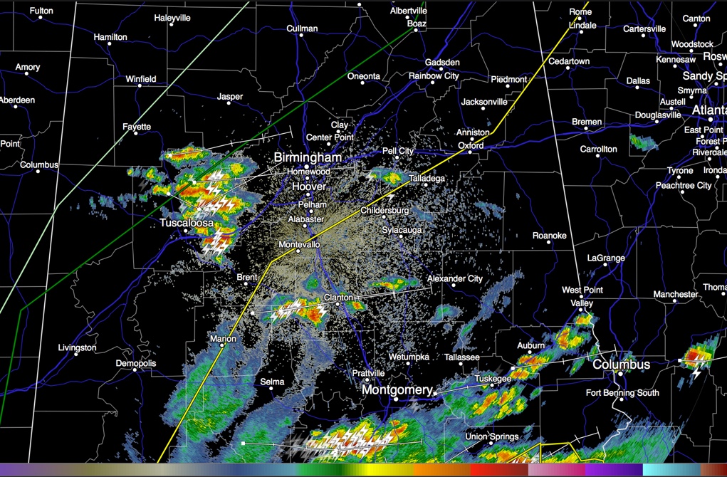
Heavy thunderstorms have developed this afternoon across Tuscaloosa County in West Alabama. They are not severe, but they do have lot sof lightning and heavy rain as well as gusty winds.
They are moving ENE and will move into Jefferson County shortly. They will reach downtown Birmingham before 4:30.
Across South Central Alabama, storms were developing across Perry and Bibb County, moving toward Clanton.
The SPC has moved the slight risk severe weather outlook southward about 50 miles, sort of as expected. It is depicted in the radar graphic as a yellow line extending from Grove Hill to Centreville to Columbiana and Talladega. The dark green line indicates the northward extent of the Marginal Risk and the light green line delineates the northern extent of the threat of storms.
South of US-82, CAPE values are over 2,000 j/kg giving the storms plenty of octane to work with. There is strong speed shear as well. Mid-level lapse rates are moderately strong as well. But there is almost no low level helicity, so tornadoes are not an issue for now. Overall moisture levels have dropped over North Central Alabama as the special balloon release from BMX indicated at 1 p.m. But low level dewpoints are still quite juicy, running in the upper 60s and lower 70s.
Storms over South Alabama are stronger, including a couple of severe ones. Two severe thunderstorm watches cover South Alabama, but one has not been issued for South Central Alabama yet. Winds gusted to 59 mph at Fairhope when the storms were over Mobile Bay.
Category: Alabama's Weather, Severe Weather
About the Author (Author Profile)
Bill Murray is the President of The Weather Factory. He is the site's official weather historian and a weekend forecaster. He also anchors the site's severe weather coverage. Bill Murray is the proud holder of National Weather Association Digital Seal #0001 @wxhistorianSubscribe
If you enjoyed this article, subscribe to receive more just like it.


