

Summer-Like Heat This Weekend
DRY PATTERN CONTINUES: Interesting to note that Birmingham’s rain total for April was 10.24″, and so far for the month of May the total is 0.00″. Seems like it is either feast or famine in the rain department; for now the dry pattern will likely continue into the weekend. And, temperatures will remain above average. We expect upper 80s tomorrow, and a high Saturday and Sunday very close to 90 degrees. With a slow increase in low level moisture over the weekend, I guess we can’t completely rule out an afternoon shower somewhere over the weekend, but the chance of any one spot getting wet is very small, and for now we won’t mention it in the formal forecast.
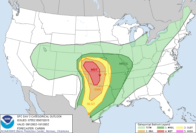
TO THE WEST: Looks like tomorrow and Saturday will offer very significant severe weather threats for the Southern Plains; especially parts of North Texas, Oklahoma, and Kansas where the Storm Prediction Center (SPC) has put up moderate risks for both days. It is very possible a few violent, long track tornadoes could form in this region, especially Saturday afternoon and evening.
TO THE EAST: A sub-tropical storm (the name will be Ana) is forming off the South Carolina coast…
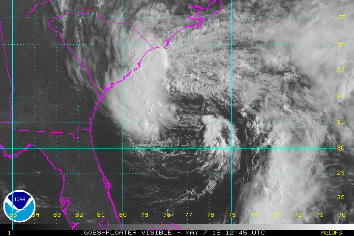
NHC will not be upgrading the system this afternoon due to limited convection near the center, but they would initiate advisories late tonight. The name of the storm will be “Ana”, and it will hang around just off the South Carolina coast for a few days before drifting inland. It will not impact Alabama’s weather in any way.
NEXT WEEK: A cold front will bring a chance of showers back to Alabama Monday night and Tuesday, but with the upper support passing well to the north, we don’t expect severe weather, and rain amounts will probably be light. The front will stall out and dissipate somewhere over Central or South Alabama at mid-week, and we might have to maintain some risk of showers into Wednesday and Thursday for the southern two-thirds of the state. See the Weather Xtreme video for maps, graphics, and more details.
GULF COAST WEATHER: The weather will stay dry through the weekend from Panama City west to Gulf Shores, with mostly sunny days and fair nights. And, while there could be a few scattered showers around, a decent part of next week is looking dry as well. Highs on the immediate coast will be in the upper 70s, with 80s inland. Sea water temperatures remain mostly in the mid 70s.
WEATHER BRAINS: Don’t forget you can listen to our weekly 90 minute netcast anytime on the web, or on iTunes. This is the show all about weather featuring many familiar voices, including our meteorologists here at ABC 33/40.
CONNECT: You can find me on all of the major social networks…
Facebook
Twitter
Google Plus
Instagram
I had a great time today visiting with the kids at Walter Kennedy Elementary in Pell City, and Kitty Stone Elementary in Jacksonville… be looking for them on the Pepsi KIDCAM on ABC 33/40 News at 5:00 and 6:00 this evening! The next Weather Xtreme video will be posted here by 7:00 a.m. tomorrow…
Category: Alabama's Weather
About the Author (Author Profile)
James Spann is one of the most recognized and trusted television meteorologists in the industry. He holds the AMS CCM designation and television seals from the AMS and NWA. He is a past winner of the Broadcast Meteorologist of the Year from both professional organizations.Subscribe
If you enjoyed this article, subscribe to receive more just like it.


