

So That Is Why I Am Sweating…
There has been a stubborn mini-ridge of high pressure holding sway over Alabama and the Southeast for the past several days. Visible satellite imagery showed the two rivers of air moving across Alabama this morning clearly: a south southeasterly low level flow around the surface high and a southwesterly flow aloft ahead of the western trough and up and over the southeastern ridge. Clouds were thickest along and east of I-65 this morning, with sunshine over western sections pushing the mercury into the 80s in places like Tuscaloosa, Jasper, Hamilton and Muscle Shoals before noon.
Cumulus clouds were starting to develop at the convective temperature (81F) was reached. Isn’t the atmosphere amazing in its predictability (at least on some levels!)
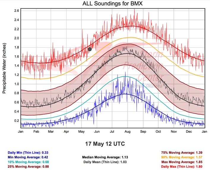
GEEKING OUT: The precipitable water value this morning based on the sounding from the National Weather Service office at the Shelby County Airport was 1.76 inches. This is right at the highest ever measured (1.77″) across Central Alabama, with records going back to 1964 at Gunter AFB in Montgomery, along with soundings from Montgomery and Centreville.

WILL IT RAIN? About 50% of you will have a little ran fall into your lives this afternoon as scattered showers and storms develop with the strong heating. Showers and storms have formed over northeastern Mississippi and Northwestern Alabama. Other newly formed showers were in East Alabama over Randolph County. Additional showers and storms will form through the afternoon and evening before dissipating around midnight. Highs this afternoon will range generally between 83F and 86F. Lows tonight will be in the middle 60s.
FOR YOUR MONDAY: Central Alabama will remain in a moist regime tomorrow as well with the approaching cold front still well to the northwest. More showers and storms will likely form to the west and push into the state at some point during the day. Highs will be well into the middle and upper 80s with a about 5-7 hours or sunshine in between and around the showers and storms.
TUESDAY: The cold front will push into Alabama on Tuesday morning and travel southeastward across the state. Some drier air will filter in behind the front, even as it fizzles over South Alabama through midweek.
Category: Alabama's Weather
About the Author (Author Profile)
Bill Murray is the President of The Weather Factory. He is the site's official weather historian and a weekend forecaster. He also anchors the site's severe weather coverage. Bill Murray is the proud holder of National Weather Association Digital Seal #0001 @wxhistorianSubscribe
If you enjoyed this article, subscribe to receive more just like it.


