

Warmer for the Weekend
High pressure at the surface will keep the weather spectacular across Alabama today as we enjoy the first third of the Memorial Day weekend. An upper ridge will allow heights to climb, so with plenty of sunshine look for highs to climb back into the 80s after a couple of nice, cooler days. The morning actually started on a cool note for the area northeast of Birmingham where Skywatchers reported morning lows in the 40s once again.
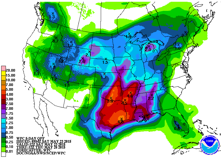
The upper ridge builds in stronger on Sunday as a strong trough comes out of the Rockies. This will keep much of the focus for rain to our west where sections of Texas, Arkansas, and Oklahoma could see rainfall amounts of 4 to 6 inches over the next several days. While clouds will increase for Central Alabama, I think we should stay dry with showers remaining just to our west.
The upper trough comes out across the Upper Mississippi River Valley from Monday into Wednesday. With a good, moist southwesterly flow, we should see fairly widespread showers and storms across Central Alabama and the Southeast US. Temperatures will be cut back just a bit thanks to the presence of clouds and showers, but most places will see highs in the lower 80s.
After the trough passes late Wednesday, we come under weak ridging for the latter part of the week, but the weather is likely to remain somewhat unsettled since we don’t see an air mass change. This means daily chances for showers mainly driven by the heat of the day. The last weekend of May could be a little wetter with the approach of another upper trough as we remain in a moist air mass.
Beach goers will enjoy plenty of sunshine today, so be sure to pack the sunscreen. Scattered showers return Sunday and into much of next week, though there will be 4 to 6 hours of sunshine each day. Highs along the coast will be in the range from about 82 to 85 degrees.
HURRICANE PREPAREDNESS WEEK: The Atlantic hurricane season begins officially June 1st, so it is that time of year for coastal areas that can be impacted by the big storms to think about their seasonal preparedness activities. More here.
Looking out into voodoo country, the overall upper air pattern begins to shift northward as we head into June. Another trough traverses the Ohio Valley around June 1st and then weak ridging expands across the southern tier of the US with the traveling storms along the US-Canadian border.
I expect to post the next Weather Xtreme Video here on Sunday morning. Check back frequently for updates on our ever-changing weather.
-Brian-
Category: Alabama's Weather
About the Author (Author Profile)
Brian Peters is one of the television meteorologists at ABC3340 in Birmingham and a retired NWS Warning Coordination Meteorologist. He handles the weekend Weather Xtreme Videos and forecast discussion and is the Webmaster for the popular WeatherBrains podcast.Subscribe
If you enjoyed this article, subscribe to receive more just like it.


