

Wet Weather Ahead
After several days of great weather, moisture will be on the increase with showers and thunderstorms possible beginning this evening and continuing for much of the week ahead. This is in stark contrast to the relatively dry May we’ve seen in Central Alabama so far.
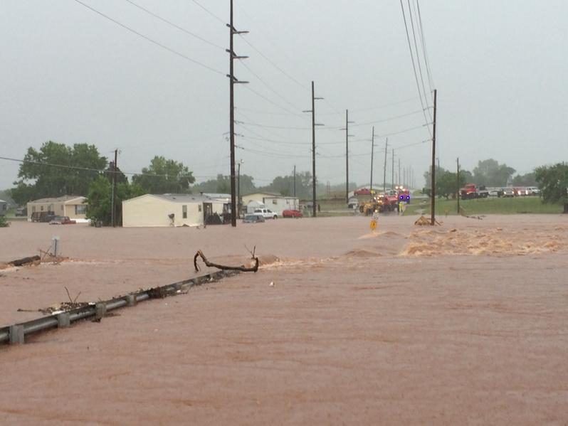
Special thanks to Joe Miller for the picture he posted via Twitter of a sample of the flooding in Oklahoma.
While our weather will be turning wetter, I do not expect to see the magnitude of flooding that Oklahoma has experienced over the last several days. But QPF forecasts suggest that we could see 1 to 3 inches of rainfall over the next 5 days as this weather system moves slowly by.
The upper trough over the southern Rockies will be ejecting northeastward over the next several days. This will increase our rain chances starting late today and continuing for much of the week ahead. The upper trough should move by us by Wednesday throwing us into a pattern of scattered showers as a relatively moist air mass remains in place across the Southeast US.
SPC has mentioned the potential for severe thunderstorms on Tuesday, Day 3, across a large section of the Tennessee and Ohio River Valleys as this trough moves by. CAPE values soar to around 3,000 j/kg during the afternoon Tuesday, so it looks like all modes of severe weather will be possible.
Once the primary trough moves by at mid-week, the weather settles into a daily shower regime with highs staying mainly in the 80s and lows in the 60s, fairly typical for late May.
For beach goers, you will enjoy plenty of sunshine today, so be sure to pack the sunscreen. Scattered showers return today and for much of the week, but there will be 6 to 8 hours of sunshine each day. Highs along the coast will be in the range from about 82 to 85 degrees. Water temperature at the Dauphin Island Sea Lab was 78 degrees. There is also a moderate risk of rip currents with the onshore flow for the next couple of days.
By the end of the week, weak ridging will occur across the Southeast US, but without an air mass change, scattered showers remain possible. The next trough begins to take shape on Saturday over the Central Plains which could spell another round of wet weather for the Southeast US for the latter half of next weekend.
Looking out into Week 2, or voodoo country, the GFS continues to suggest a relatively cool and start to June with general troughiness over the eastern half of the country.
James Spann will be back on Monday with the next edition of the Weather Xtreme Video. You can always check back here for the latest updates on our ever changing weather. Enjoy the day, and Godspeed.
-Brian-
Category: Alabama's Weather
About the Author (Author Profile)
Brian Peters is one of the television meteorologists at ABC3340 in Birmingham and a retired NWS Warning Coordination Meteorologist. He handles the weekend Weather Xtreme Videos and forecast discussion and is the Webmaster for the popular WeatherBrains podcast.Subscribe
If you enjoyed this article, subscribe to receive more just like it.


