

Severe Thunderstorm Warning Bibb/Chilton
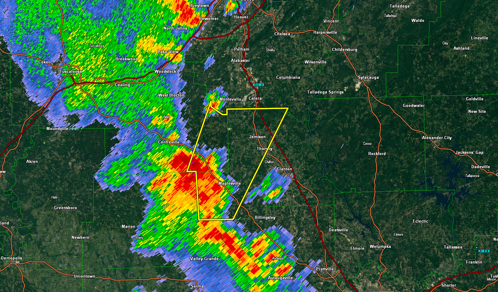
Strong storms are crossing US-82 between Maplesville and Centerville at this hour.
They will affect Jemsion and Thorsby and eventually Montevallo and Caera.
Storms have intensified west of Birmingham in the past few minutes. They are going to affect Hueywton, Concord and Rock Creek.
The shower that caused a delay at the SEC Championship game at the Hoover Met has grown upscale and will be merging into the storms in western Jefferson County.
THE NATIONAL WEATHER SERVICE IN BIRMINGHAM HAS ISSUED A
* SEVERE THUNDERSTORM WARNING FOR…
SOUTHEASTERN BIBB COUNTY IN CENTRAL ALABAMA…
WESTERN CHILTON COUNTY IN CENTRAL ALABAMA…
* UNTIL 515 PM CDT
* AT 427 PM CDT…A SEVERE THUNDERSTORM WAS LOCATED OVER LAWLEY…OR
13 MILES SOUTHWEST OF JEMISON…MOVING NORTHEAST AT 40 MPH.
HAZARD…60 MPH WIND GUSTS AND QUARTER SIZE HAIL.
SOURCE…RADAR INDICATED.
IMPACT…HAIL DAMAGE TO VEHICLES IS EXPECTED. EXPECT WIND DAMAGE
TO ROOFS…SIDING AND TREES.
* LOCATIONS IMPACTED INCLUDE…
CALERA…JEMISON…THORSBY…MAPLESVILLE…CHILTON COUNTY MOTOR
SPORTS PARK…BRIERFIELD IRONWORKS PARK…TALLADEGA NATIONAL
FOREST…ASHBY…PARNELL…LAWLEY…RANDOLPH…ISABELLA…TRIO…
CAMPBELL…MINOOKA PARK AND STANTON.
Category: Severe Weather
About the Author (Author Profile)
Subscribe
If you enjoyed this article, subscribe to receive more just like it.


