

More Rain/Storms For Alabama Today
RADAR CHECK: The band of severe storms that brought serious flooding and some wind damage to parts of Texas, Oklahoma, Arkansas, and Louisiana last night, as expected, has been steadily weakening early this morning, and is entering West Alabama as I write this around sunrise.
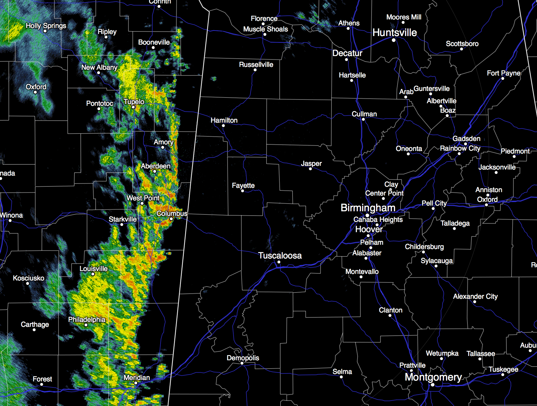
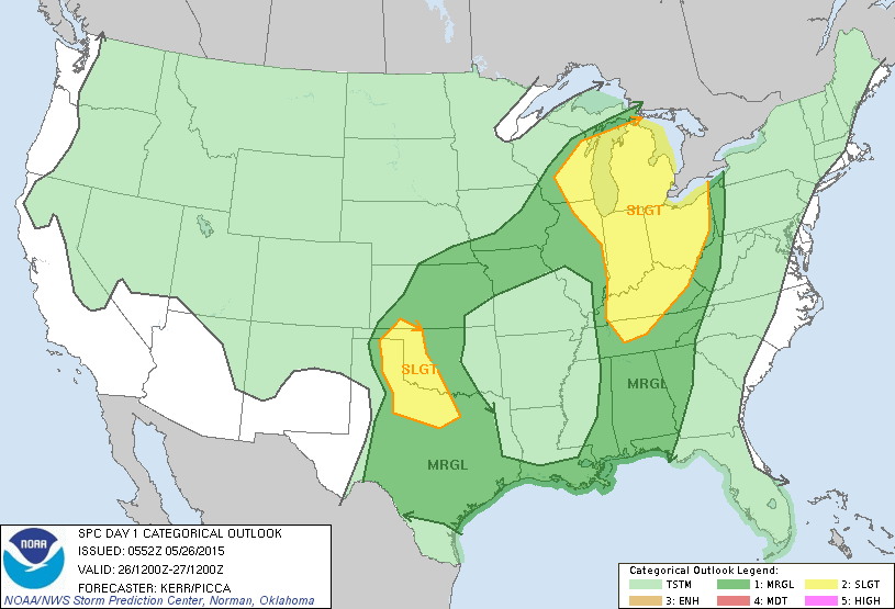
We will forecast a good chance of rain and thunderstorms for all of Alabama again today, and we remain unimpressed with the severe weather threat. SPC has dropped the “slight risk” for our state, and we are now just in a “marginal risk” through tonight. Wind fields are weak, and overall severe weather parameters are low. But, a few strong storms are possible later with gusty winds and heavy rain.
Rain tapers off from west to east this afternoon; many communities won’t get out of the 70s again today because of clouds and rain.
TOMORROW: Another fairly wet day with a deep moisture axis in place; we expect scattered to numerous showers and thunderstorms with a high in the low 80s. SPC has a “marginal” risk of severe weather in place for much of Alabama.
THURSDAY/FRIDAY: Showers and storms become more scattered in nature, and will happen mostly during the afternoon and evening hours as the air aloft become warmer. Expect a mix of sun and clouds both days with a high in the low to mid 80s.
THE WEEKEND: Not much change. Partly sunny, warm, and humid Saturday and Sunday with the usual risk of “scattered, mostly afternoon and evening showers and thunderstorms”. Highs over the weekend will be generally in the 83 to 86 degree range, right at seasonal levels for late May in Alabama.
And, no real change is expected into early next week as June begins. See the Weather Xtreme video for maps, graphics, and more details.
AT THE BEACH: Occasionally cloudy today from Panama City over to Gulf Shores with a few showers and storms likely, then about 6 to 8 hours of sunshine each day tomorrow through the weekend, with the daily risk of scattered showers and thunderstorms (very routine for summer). Highs will remain in the low 80s on the immediate coast; the sea water temperature early this morning at the Dauphin Island Sea Lab is 79 degrees.
WOMEN’S COLLEGE WORLD SERIES: Both Auburn and Alabama are playing in Oklahoma City later this week and over the weekend; showers and thunderstorms are likely on a daily basis Thursday through Saturday, so expect rain delays. Showers thin out a bit Sunday; highs will be in the 77-81 degree range most days. Some flooding issues are not out of the question since the soil there is totally saturated.
WEATHER BRAINS: Don’t forget you can listen to our weekly 90 minute netcast anytime on the web, or on iTunes. This is the show all about weather featuring many familiar voices, including our meteorologists here at ABC 33/40. Scroll down for the show notes on the new episode we recorded last night as we remember J.B. Elliott, the great American weather legend that passed away earlier this month.
CONNECT: You can find me on all of the major social networks…
Facebook
Twitter
Google Plus
Instagram
Look for the next Weather Xtreme video here by 4:00 this afternoon… enjoy the day…
Category: Alabama's Weather
About the Author (Author Profile)
James Spann is one of the most recognized and trusted television meteorologists in the industry. He holds the AMS CCM designation and television seals from the AMS and NWA. He is a past winner of the Broadcast Meteorologist of the Year from both professional organizations.Subscribe
If you enjoyed this article, subscribe to receive more just like it.


