

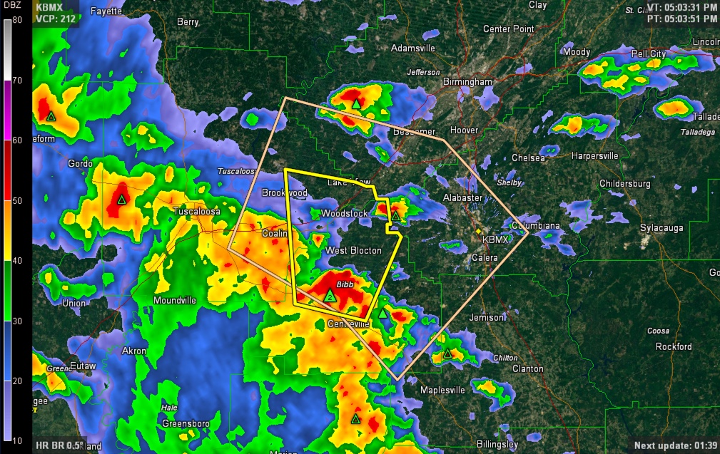
Severe Thunderstorm Warning for Bibb and Tuscaloosa Counties
The National Weather Service has issued a severe thunderstorm warning for parts of Bibb and Tuscaloosa Counties in West Central Alabama. The warning is outlined in yellow. The peach outline is a significant weather alert from the NWS Birmingham for strong storms that will affect the alert area through 5:30 p.m. That area will see strong gusty winds, small hail and torrential rains.
A line of thunderstorms extends generally along US-82 at this hour from Pickens and Lamar Counties through Tuscaloosa County down to the Montgomery area.
The most intense storms are from near Brookwood to Vance to north of West Blocton moving north northeast. They will affect West Blocton, North Bibb and Lake View over the next 30 minutes.
They will reach southwestern Jefferson County by 5:45 and move across the Birmingham Metro between 6 and 7 p.m.
Large hail to one inch in diameter and 60 mph winds are possible.
THE NATIONAL WEATHER SERVICE IN BIRMINGHAM HAS ISSUED A
* SEVERE THUNDERSTORM WARNING FOR…
CENTRAL BIBB COUNTY IN CENTRAL ALABAMA…
SOUTHEASTERN TUSCALOOSA COUNTY IN WEST CENTRAL ALABAMA…
* UNTIL 530 PM CDT
* AT 504 PM CDT…A SEVERE THUNDERSTORM WAS LOCATED NEAR EOLINE…OR
NEAR CENTREVILLE…MOVING NORTH AT 25 MPH.
HAZARD…60 MPH WIND GUSTS AND QUARTER SIZE HAIL.
SOURCE…RADAR INDICATED.
IMPACT…HAIL DAMAGE TO VEHICLES IS EXPECTED. EXPECT WIND DAMAGE
TO ROOFS…SIDING AND TREES.
* LOCATIONS IMPACTED INCLUDE…
BRENT…CENTREVILLE…LAKE VIEW…BROOKWOOD…VANCE…WOODSTOCK…
WEST BLOCTON…EOLINE…NORTH BIBB…MERCEDES BENZ OF ALABAMA…
ABERNANT…TANNEHILL IRONWORKS STATE PARK…HEBRON…HARMON…
CAFFEE JUNCTION…MARVEL…BUCKSVILLE…EAST BROOKWOOD AND GREEN
POND.
Category: Severe Weather
About the Author (Author Profile)
Subscribe
If you enjoyed this article, subscribe to receive more just like it.


