

Hot and Mostly Dry
Not much change in the overall thinking for our weather in Central Alabama as we continue to watch events develop in the western Gulf of Mexico. Bill is not yet Bill, but could become Bill at almost any time.
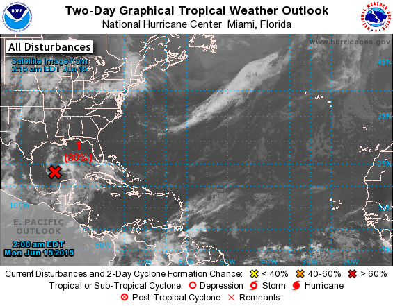
Over the Southeast US, high pressure at the surface and aloft is keeping a clockwise circulation that should steer the developments in the western Gulf into the Central Texas coast on Tuesday and Wednesday. Warm water temperatures suggest we could see development while weak shear continues to wreak havoc on the development of that system. No matter what it is called, it is likely to bring rain to Texas, Oklahoma, and Arkansas and eventually into the Ohio River Valley with amounts of 5 to 8 inches possible along the track of the decaying system.
Tracking the weak feature in the upper air charts, shows that it should move across the Ohio River Valley at the end of the week as a weak frontal system approaches the Southeast. This is likely to produce an uptick in showers and thunderstorms along with some additional cloudiness which may take a few degrees off our temperatures, but nothing that I would call a big break for the heat as highs are likely to remain in the 90 to 94 range.
Sunday officially starts the summer season as the sun reaches its farthest point north and the days begin to get shorter.
By Monday, the upper ridge is beginning to take hold to the west of us as we stay in a moist and warm environment with daily shower chances.
At the beach, you can expect about 6 to 8 hours of sunshine today along the coast with the usual risk of scattered showers and thunderstorms. Expect increasing amounts of sun and fewer storms much of this week. Highs on the immediate coast will be in the upper 80s, with lower 90s just inland. The sea water temperature at Dauphin Island Sea Lab was 83 degrees yesterday afternoon. Due to the onshore flow, the risk of rip currents is expected to be high for the next several days.
I’ll be a little late with the Weather Xtreme Video tomorrow morning due to work schedule, but look for a post by mid-morning. Enjoy the day, stay cool, and Godspeed.
-Brian-
Category: Alabama's Weather
About the Author (Author Profile)
Brian Peters is one of the television meteorologists at ABC3340 in Birmingham and a retired NWS Warning Coordination Meteorologist. He handles the weekend Weather Xtreme Videos and forecast discussion and is the Webmaster for the popular WeatherBrains podcast.Subscribe
If you enjoyed this article, subscribe to receive more just like it.


