

Heat Levels Rising, Then Falling
SUMMER HEAT: An upper ridge will push afternoon temperatures up into the mid to upper 90s across North/Central Alabama today through Wednesday. The hottest temperature so far at Birmingham this summer is 96 degrees, recorded last Wednesday (June 17)… we might be able to beat that by a degree or two tomorrow or Wednesday.
This is no “heat emergency”, and seeing numbers like this in the summer at this latitude are fairly common. If you listen to our show “WeatherBrains”, you know we won’t bombard you with idiotic ” heat tips” like “go into an air conditioned room” and “drink water” when you are hot. But, if you are working outside no doubt it will be very uncomfortable for the first half of the week.
And, the warm air aloft associated with the upper ridge will keep the weather mostly dry… an afternoon storm is not totally out of the question, but they will be few and far between.
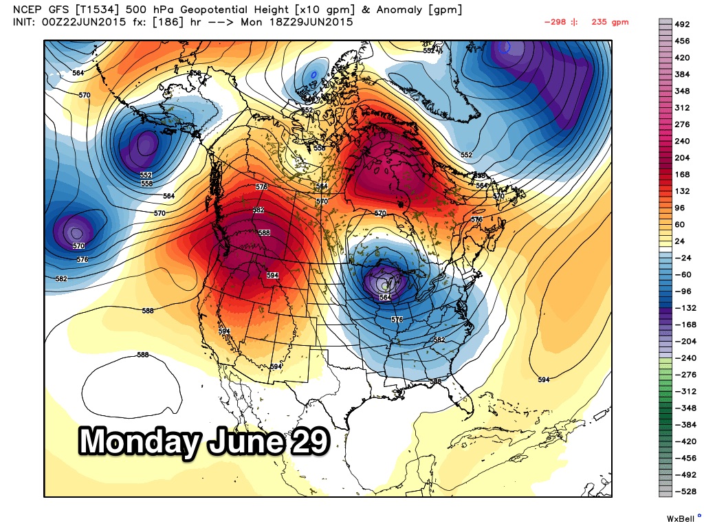
HEAT LEVELS FALL LATER THIS WEEK: An upper air pattern change will bring a better chance of showers and storms, and lower heat levels to Alabama by Thursday and Friday. A high amplitude pattern will feature an upper ridge over the western half of the nation, where you will find the hottest weather, and an upper trough over the eastern states, with higher rain chances and cooler temperatures. By Friday there is a good chance we won’t get out of the 80s with cloudy periods and scattered to numerous showers and thunderstorms.
THE ALABAMA WEEKEND: The upper trough stays in place, meaning a few passing showers and thunderstorms are likely both Saturday and Sunday. Not a “wash-out”, but if you have something planned outside no doubt you will have several rain delays. The GFS model is suggesting highs only in the mid 80s both days, well below average for late June in Alabama.
The upper air pattern will persist into at least the first half of next week, with below average temperatures and the chance of scattered showers and thunderstorms on a daily basis. See the Weather Xtreme video for maps, graphics, and more details.
TROPICS: The Atlantic basin is very quiet; there is a large area of dry air from the African deserts over the deep tropics, and tropical storm formation is not expected this week.
AT THE BEACH: Expect another sunny day on the coast today from Panama City Beach west to Gulf Shores, then about 8 to 10 hours of sunshine each day tomorrow through Friday with widely scattered thunderstorms. Storms could be a little more numerous over the upcoming weekend, but you will still see a decent supply of sunshine Saturday and Sunday. Highs on the immediate coast will be in the mid to upper 80s, with 90s inland. The sea water temperature early this morning at the Dauphin Island Sea Lab is 83 degrees.
WEATHER BRAINS: Don’t forget you can listen to our weekly 90 minute netcast anytime on the web, or on iTunes. This is the show all about weather featuring many familiar voices, including our meteorologists here at ABC 33/40. We will produce this week’s show tonight at 8:30 CT… you can watch it on “James Spann 24/7” on cable systems around the state, or on the web here.
CONNECT: You can find me on all of the major social networks…
Facebook
Twitter
Google Plus
Instagram
Look for the next Weather Xtreme video here by 4:00 this afternoon….
Category: Alabama's Weather
About the Author (Author Profile)
James Spann is one of the most recognized and trusted television meteorologists in the industry. He holds the AMS CCM designation and television seals from the AMS and NWA. He is a past winner of the Broadcast Meteorologist of the Year from both professional organizations.Subscribe
If you enjoyed this article, subscribe to receive more just like it.


