

A Break In The Heat Late This Week
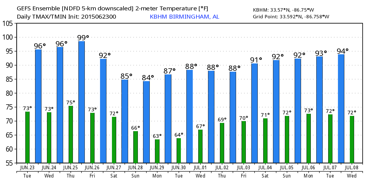
HOT THROUGH MID-WEEK: An upper ridge across the southern U.S. will keep our weather pretty much unchanged through tomorrow with hot, humid days and isolated thunderstorms during the afternoon and evening hours. Highs will remain in the 94-98 degree range, and the chance of any one spot seeing an afternoon storm is about one in five. And, like yesterday, storms that form during the peak of the heat will pack a punch, with lots of lightning and potential for localized areas of strong winds (wet microbursts).
There were a few small pockets of tree damage yesterday from afternoon storms near McCalla, and Roebuck.
HEAT RELIEF ON THE WAY: I still think we see mid 90s Thursday with a little higher coverage of afternoon storms, but the big break begins Friday as an upper trough forms over the eastern third of the U.S. Showers and storms become more numerous Friday, and there is a good chance we won’t get out of the 80s.
THE ALABAMA WEEKEND: Saturday looks relatively wet, with occasional showers and thunderstorms. But, there will be some decent breaks in the rain, and the sun will be out at times. On the positive side, the GFS is printing a high of only 82 degrees for Birmingham Saturday afternoon, and there is a decent chance some North Alabama communities won’t get out of the 70s because of the clouds and showers. A very nice break from the summer heat.
Then, on Sunday, the surface front pushes down toward U.S. 80, putting the northern half of the state in dry air. Based on the projected upper air pattern, this is very possible, and we will forecast partly to mostly sunny weather Sunday from I-20 north with no mention of rain, along with lower humidity levels. Showers and storms Sunday should be confined to the southern half of Alabama. And, temperatures stay pleasant with a high in the mid 80s.
NEXT WEEK: Looks most all of Alabama will be in dry air Monday, with ample sunshine, low humidity (at least for a summer day), and a high in the 80s. Some of the cooler pockets across North Alabama will visit the 50s at daybreak Monday, a little preview of fall. Then, moist air comes back Tuesday and Wednesday and we will mention a chance of scattered showers and storms both days. See the Weather Xtreme video for maps, graphics, and more details.
AT THE BEACH: We project about 7 to 9 hours of sunshine each day through Saturday along the Gulf Coast from Panama City Beach west to Gulf Shores, with a few widely scattered showers and thunderstorms around. Coverage of showers and storms will be a little higher Sunday, but there will still be a decent amount of sunshine. Highs on the immediate coast will be in the upper 80s, with 90s inland. The sea water temperature early this morning at the Dauphin Island Sea Lab is 85 degrees.
TROPICS: The Atlantic basin is covered by dry air off the African continent, and tropical storm formation is not expected anytime soon.
WEATHER BRAINS: Don’t forget you can listen to our weekly 90 minute netcast anytime on the web, or on iTunes. This is the show all about weather featuring many familiar voices, including our meteorologists here at ABC 33/40. Scroll down for the show notes on the new episode we recorded last night.
CONNECT: You can find me on all of the major social networks…
Facebook
Twitter
Google Plus
Instagram
Look for the next Weather Xtreme video here by 4:00 this afternoon… enjoy the day!
Category: Alabama's Weather
About the Author (Author Profile)
James Spann is one of the most recognized and trusted television meteorologists in the industry. He holds the AMS CCM designation and television seals from the AMS and NWA. He is a past winner of the Broadcast Meteorologist of the Year from both professional organizations.Subscribe
If you enjoyed this article, subscribe to receive more just like it.


