

Heat Levels Fall Friday
SEVERE THUNDERSTORM WATCH FOR EAST ALABAMA: Despite this watch for East Alabama until 9pm CT… the radar is relatively quiet at mid-afternoon…
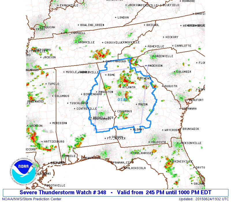
Scattered storms will remain possible statewide through tonight; a few storms over East Alabama could produce strong winds in the watch area this evening. Like most summer afternoons, the thunderstorms will be scattered, and random.
TOMORROW: The weather won’t change much tomorrow. Still hot and humid, and the risk of a few widely scattered thunderstorms during the afternoon and evening hours. The high will be in the mid 90s.
HEAT RELIEF FRIDAY: The advertised pattern change begins Friday, as a long wave upper trough forms over the eastern half of the U.S. Here in Alabama, showers and storms will increase in coverage by Friday afternoon, and a good chance most communities won’t get out of the 80s. SPC has the northern third of the state in a “marginal” severe weather risk Friday afternoon.
THE ALABAMA WEEKEND: Saturday continues to look relatively wet with a rare late June cold front approaching, with scattered to numerous showers and thunderstorms during the day along with a high only in the low to mid 80s. There will be some breaks in the rain, and the sun might peek out at times, but expect rain delays if you have something planned outdoors.
Sunday looks delightful for the northern half of the state, with ample sunshine, lower humidity, and a high in the mid 80s. Showers and storms will be confined to the southern quarter of Alabama.
NEXT WEEK: Dry, continental air will stay in place Monday. Some of the colder spots across North Alabama could wind up in the cool 50s for a brief preview of fall. The day will feature ample sunshine along with a high in the upper 80s… humidity levels will stay low for late June.
We will mention a small risk of a shower Tuesday, and then scattered showers and storms will return by Wednesday and Thursday with increasing moisture levels. Highs during the mid-week period will be in the 87 to 90 degree range. See the Weather Xtreme video for maps, graphics, and more details.
AT THE BEACH: About 7 to 9 hours of sunshine along the coast from Panama City west to Gulf Shores through Saturday with scattered storms possible daily. Coverage of showers and storms will increase a bit Sunday and Monday, but even on those days you will see a decent amount of sunshine. Then, for the rest of next week, it looks like routine summer weather, with partly to mostly sunny days and the usual risk of scattered thunderstorms. Highs on the immediate coast will be in the mid to upper 80s, with low 90s inland. The sea water temperature this afternoon at the Dauphin Island Sea Lab is 85 degrees.
TROPICS: A large amount of dry air covers the Atlantic tropical basin, and tropical storm formation is not expected anytime soon.
WEATHER BRAINS: Don’t forget you can listen to our weekly 90 minute netcast anytime on the web, or on iTunes. This is the show all about weather featuring many familiar voices, including our meteorologists here at ABC 33/40.
CONNECT: You can find me on all of the major social networks…
Facebook
Twitter
Google Plus
Instagram
I enjoyed seeing the kids in the summer program at Stephens Elementary School in Alexander City this morning… be looking for theme on the Pepsi KIDCAM today at 5:00 on ABC 33/40 News! The next Weather Xtreme video will be posted here by 7:00 a.m. tomorrow…
Category: Alabama's Weather
About the Author (Author Profile)
James Spann is one of the most recognized and trusted television meteorologists in the industry. He holds the AMS CCM designation and television seals from the AMS and NWA. He is a past winner of the Broadcast Meteorologist of the Year from both professional organizations.Subscribe
If you enjoyed this article, subscribe to receive more just like it.


