

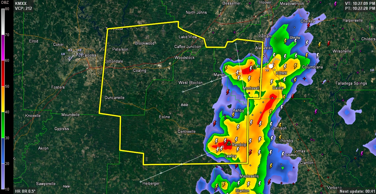
Severe Thunderstorm Warning: Bibb, Tuscaloosa, Shelby
Storms continue to push westward tonight and are still capable of strong winds and hail.
The system has congealed into a nice little convective system that extends from western Shelby County down to Greenville in Butler County.
Areas from just south of Tuscaloosa to Monroeville will be under the gun over the next couple of hours.
SPECIAL NOTE
The NWS in Birmingham at the Shelby County Airport in Calera has lost commercial power and is on its backup generator. Services are not being affected except for a little bit of social media. I can just picture Gary Goggins typing away on his smartphone! Thanks for all you do BMX!
THE NATIONAL WEATHER SERVICE IN BIRMINGHAM HAS ISSUED A
* SEVERE THUNDERSTORM WARNING FOR…
BIBB COUNTY IN CENTRAL ALABAMA…
SOUTHWESTERN SHELBY COUNTY IN CENTRAL ALABAMA…
SOUTHEASTERN TUSCALOOSA COUNTY IN WEST CENTRAL ALABAMA…
* UNTIL 1115 PM CDT
* AT 1025 PM CDT…SEVERE THUNDERSTORMS WERE LOCATED ALONG A LINE
EXTENDING FROM NEAR SPLASH ADVENTURE TO NEAR HARRISBURG…MOVING
NORTHWEST AT 25 MPH.
HAZARD…60 MPH WIND GUSTS AND QUARTER SIZE HAIL.
SOURCE…RADAR INDICATED.
IMPACT…HAIL DAMAGE TO VEHICLES IS EXPECTED. EXPECT WIND DAMAGE
TO ROOFS…SIDING AND TREES.
* LOCATIONS IMPACTED INCLUDE…
SOUTHEASTERN TUSCALOOSA…ALABASTER…HELENA…MONTEVALLO…
BRENT…CENTREVILLE…HOLT…LAKE VIEW…BROOKWOOD…COALING…
VANCE…WOODSTOCK…WEST BLOCTON…WILTON…BRIERFIELD IRONWORKS
PARK…TALLADEGA NATIONAL FOREST…LAKE WILDWOOD…ASHBY…MERCEDES
BENZ OF ALABAMA AND MAYLENE.
Category: Severe Weather
About the Author (Author Profile)
Bill Murray is the President of The Weather Factory. He is the site's official weather historian and a weekend forecaster. He also anchors the site's severe weather coverage. Bill Murray is the proud holder of National Weather Association Digital Seal #0001 @wxhistorianSubscribe
If you enjoyed this article, subscribe to receive more just like it.


